Bijlands Kanaal
Encyclopedia

Canal
Canals are man-made channels for water. There are two types of canal:#Waterways: navigable transportation canals used for carrying ships and boats shipping goods and conveying people, further subdivided into two kinds:...
in the Dutch
Netherlands
The Netherlands is a constituent country of the Kingdom of the Netherlands, located mainly in North-West Europe and with several islands in the Caribbean. Mainland Netherlands borders the North Sea to the north and west, Belgium to the south, and Germany to the east, and shares maritime borders...
province
Province
A province is a territorial unit, almost always an administrative division, within a country or state.-Etymology:The English word "province" is attested since about 1330 and derives from the 13th-century Old French "province," which itself comes from the Latin word "provincia," which referred to...
of Gelderland
Gelderland
Gelderland is the largest province of the Netherlands, located in the central eastern part of the country. The capital city is Arnhem. The two other major cities, Nijmegen and Apeldoorn have more inhabitants. Other major regional centers in Gelderland are Ede, Doetinchem, Zutphen, Tiel, Wijchen,...
, near the Dutch-German
Germany
Germany , officially the Federal Republic of Germany , is a federal parliamentary republic in Europe. The country consists of 16 states while the capital and largest city is Berlin. Germany covers an area of 357,021 km2 and has a largely temperate seasonal climate...
border
Border
Borders define geographic boundaries of political entities or legal jurisdictions, such as governments, sovereign states, federated states and other subnational entities. Some borders—such as a state's internal administrative borders, or inter-state borders within the Schengen Area—are open and...
. It is currently by far the most important river-stretch of the Rhine when that major river enters the Netherlands.
It was dug between 1773 and 1776 to cut off a large bend in river
River
A river is a natural watercourse, usually freshwater, flowing towards an ocean, a lake, a sea, or another river. In a few cases, a river simply flows into the ground or dries up completely before reaching another body of water. Small rivers may also be called by several other names, including...
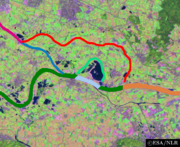
Waal to improve water regulation. This bend, and comparable waters, are currently only minor streams. They are known as the minor Oude Waal and De Bijland, and the larger Oude Rijn
Oude Rijn
Oude Rijn may refer to:* Oude Rijn - A cut-off section of the river Rhine in the province of Gelderland* Oude Rijn - A Rhine branch in the province of Utrecht and South Holland, from Harmelen to the North Sea....
. The, more or less, defunct flows now only serve one purpose: to function as a buffer zone between the free flowing Waal and Nederrijn
Nederrijn
thumb|left|300px|Course of the NederrijnNederrijn is the name of the Dutch part of the River Rhine from the confluence at the town of Angeren of the cut-off Rhine bend of Oude Rijn and the Pannerdens Kanaal...
on one side and the abandoned stream-beds on the other side. The defuncts streams are shallow waters for most of the time and serve as an important spawning ground for all kinds of fish (since they remained connected to the main river through small creeks).
However, in times of extreme high water-levels the 'dead' waters spring to life again, as the result of artificial overflow-devices. From times to times, the Oude Waal and De Bijland can temporarily taste the freedom of a free-flowing river. The area surrounding the 'dead' rivers is known for its historical significance and is a relic of a type of historical dyke landscape that is more and more becoming rare in The Netherlands.

Federation
A federation , also known as a federal state, is a type of sovereign state characterized by a union of partially self-governing states or regions united by a central government...
of the Dutch Republic
Dutch Republic
The Dutch Republic — officially known as the Republic of the Seven United Netherlands , the Republic of the United Netherlands, or the Republic of the Seven United Provinces — was a republic in Europe existing from 1581 to 1795, preceding the Batavian Republic and ultimately...
, undertook to better regulate water
Water
Water is a chemical substance with the chemical formula H2O. A water molecule contains one oxygen and two hydrogen atoms connected by covalent bonds. Water is a liquid at ambient conditions, but it often co-exists on Earth with its solid state, ice, and gaseous state . Water also exists in a...
flow around the Rhine-Waal fork. It is named after Castle
Castle
A castle is a type of fortified structure built in Europe and the Middle East during the Middle Ages by European nobility. Scholars debate the scope of the word castle, but usually consider it to be the private fortified residence of a lord or noble...
De Bijland, which had been destroyed by the river Waal circa 1750. In addition to the Bijlands Kanaal, the Pannerdens Kanaal
Pannerdens Kanaal
thumb|300px|right|Processed [[satellite]] [[image]] of the [[Rhine]]-[[Waal |Waal]] fork showing the location of the Pannerdens Kanaal .The Pannerdens Kanaal is a canal in the Netherlands that was dredged between 1701 and 1709 to cut off a large, shallow bend of river Rhine and so improve river...
is part also part of the same river regulation system. Both canals cut off shallow and slow-moving bends in the river Rhine, now known as the Oude Waal and De Bijland. Although both waters are called "Kanaal" (English: canal) they are now an indistinguishable part of the river and both lost all characteristics of an artificial structure. The area surrounding the both the main rivers Waal and Rhine, and the mostly defunct abandoned streams, are all part of the extensive nature restoration project known as the Gelderse Poort.
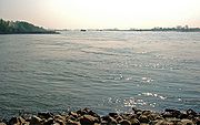
Nowadays, the canal is of enormous importance to Rhine navigation, being part of the main Rhine waterway
Waterway
A waterway is any navigable body of water. Waterways can include rivers, lakes, seas, oceans, and canals. In order for a waterway to be navigable, it must meet several criteria:...
and the first section of the Waal-Rhine fork.

