Climate of the Los Angeles Basin
Encyclopedia

Los Angeles Basin
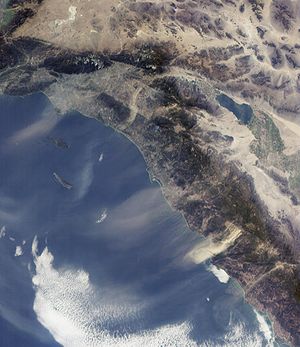
The Los Angeles Basin is the coastal sediment-filled plain located between the Peninsular and Transverse ranges in southern California in the United States containing the central part of the city of Los Angeles as well as its southern and southeastern suburbs...
is noted for its moderate weather. It is characterized by a Mediterranean climate
Mediterranean climate
A Mediterranean climate is the climate typical of most of the lands in the Mediterranean Basin, and is a particular variety of subtropical climate...
or seasonal changes in rainfall——dry summer and rainy winter——but relatively modest transitions in temperature. Under the modified Köppen climate classification
Köppen climate classification
The Köppen climate classification is one of the most widely used climate classification systems. It was first published by Crimea German climatologist Wladimir Köppen in 1884, with several later modifications by Köppen himself, notably in 1918 and 1936...
, the coast is classified as Csb and the inland areas as Csa.
Summers are warm to hot and dry with an average August high/low at LAX of 76.6 °F (24.8 °C) and 64.2 °F (17.9 °C). The same figures at the University of Southern California
University of Southern California
The University of Southern California is a private, not-for-profit, nonsectarian, research university located in Los Angeles, California, United States. USC was founded in 1880, making it California's oldest private research university...
downtown campus are 84.8 °F (29.3 °C) and 65.6 °F (18.7 °C). However temperatures sometimes exceed 90 °F (32.2 °C) during the summer. Winters are mild and somewhat rainy with high temperatures at LAX of 65.5 °F (18.6 °C) and lows of 47.8 °F (8.8 °C). Spring and autumn bring mild days with cool evenings and are generally dry.
The Los Angeles area is also subject to the phenomena typical of a microclimate
Microclimate
A microclimate is a local atmospheric zone where the climate differs from the surrounding area. The term may refer to areas as small as a few square feet or as large as many square miles...
. As such, the daytime temperatures can vary as much as 36 °F (20 °C) between inland areas and the coast.
Most of the rainfall occurs during winter and spring (February is considered the wettest month). Sometimes rainfall can occur in the summer from monsoon thunderstorms, but this is unusual. Los Angeles averages 15.1 inches (384 mm) of precipitation per year, but is lower at the coast and higher at the mountains. Tornadoes are rare, however, weak-to-moderate-strength waterspout
Waterspout
A waterspout is an intense columnar vortex that occurs over a body of water and is connected to a cumuliform cloud. In the common form, it is a non-supercell tornado over water. While it is often weaker than most of its land counterparts, stronger versions spawned by mesocyclones do occur...
s sometimes occur during warm winter storms, although this is unusual. Snow
Snow
Snow is a form of precipitation within the Earth's atmosphere in the form of crystalline water ice, consisting of a multitude of snowflakes that fall from clouds. Since snow is composed of small ice particles, it is a granular material. It has an open and therefore soft structure, unless packed by...
is extremely rare in the Los Angeles basin, but the nearby San Gabriel Mountains
San Gabriel Mountains
The San Gabriel Mountains Range is located in northern Los Angeles County and western San Bernardino County, California, United States. The mountain range lies between the Los Angeles Basin and the Mojave Desert, with Interstate 5 to the west and Interstate 15 to the east...
typically receive snow every winter season. The greatest snowfall recorded in downtown Los Angeles was 2 inches (5 cm) on January 15, 1932.
Overview
Santa Ana Winds
The Santa Ana winds are strong, extremely dry offshore windWind
Wind is the flow of gases on a large scale. On Earth, wind consists of the bulk movement of air. In outer space, solar wind is the movement of gases or charged particles from the sun through space, while planetary wind is the outgassing of light chemical elements from a planet's atmosphere into space...
s that characteristically sweeps across Southern California
Southern California
Southern California is a megaregion, or megapolitan area, in the southern area of the U.S. state of California. Large urban areas include Greater Los Angeles and Greater San Diego. The urban area stretches along the coast from Ventura through the Southland and Inland Empire to San Diego...
and northern Baja California
Baja California
Baja California officially Estado Libre y Soberano de Baja California is one of the 31 states which, with the Federal District, comprise the 32 Federal Entities of Mexico. It is both the northernmost and westernmost state of Mexico. Before becoming a state in 1953, the area was known as the North...
during late fall into winter season. They range from hot to cold, depending on the prevailing temperatures in the source region, the Great Basin
Great Basin
The Great Basin is the largest area of contiguous endorheic watersheds in North America and is noted for its arid conditions and Basin and Range topography that varies from the North American low point at Badwater Basin to the highest point of the contiguous United States, less than away at the...
and upper Mojave Desert
Mojave Desert
The Mojave Desert occupies a significant portion of southeastern California and smaller parts of central California, southern Nevada, southwestern Utah and northwestern Arizona, in the United States...
. Nevertheless, the winds are notorious for causing hot, dry weather due to compressional heating of the lower atmosphere.
Extreme Weather
In downtown Los Angeles, weather records began on July 1, 1877. The highest temperature recorded in downtown Los Angeles was 113 °F (45 °C) on September 27, 2010. The lowest temperature was 28 °F (-2.2 °C) on January 7, 1913 and on January 4, 1949. The wettest year was 2005 with 37.25 inches and the driest year was 2007 with 3.21 inches. The greatest rainfall in one month was 14.94 inches in January 1969. The greatest rainfall in 24 hours was 5.68 inches on March 2, 1938.At the Los Angeles International Airport
Los Angeles International Airport
Los Angeles International Airport is the primary airport serving the Greater Los Angeles Area, the second-most populated metropolitan area in the United States. It is most often referred to by its IATA airport code LAX, with the letters pronounced individually...
, the highest recorded temperature was 110 °F (43.3 °C) on September 26, 1963. The lowest temperature was 27 °F (-2.8 °C) on January 4, 1949. The wettest year was 1983 with 29.46 inches (748 mm) and the driest year was 1947 with 2.95 inches (74.9 mm). The greatest rainfall in one month was 13.79 inches (350 mm) in February 1998. The greatest rainfall in 24 hours was 5.6 inches (142.2 mm) on November 21, 1967.
In Long Beach, the highest recorded temperature was 111 °F (43.9 °C) on October 16, 1958, and October 15, 1961, and again on September 27, 2010. The lowest temperature was 21 °F (-6.1 °C) on January 20, 1922. The wettest year was 1978 with 27.67 inches (703 mm). The driest year was 2002 with 2.63 inches (66.8 mm). The greatest rainfall in one month was 14.5 inches (368 mm) in January 1969, including a record 24-hour rainfall of 6.71 inches (170.4 mm) on January 20 that month. The record snowfall was 1.5 inches (3.8 cm) in January 1949.

