Emeryville Crescent State Marine Reserve
Encyclopedia

Oakland, California
Oakland is a major West Coast port city on San Francisco Bay in the U.S. state of California. It is the eighth-largest city in the state with a 2010 population of 390,724...
to the foot of Powell Street in Emeryville, California
Emeryville, California
Emeryville is a small city located in Alameda County, California, in the United States. It is located in a corridor between the cities of Berkeley and Oakland, extending to the shore of San Francisco Bay. Its proximity to San Francisco, the Bay Bridge, the University of California, Berkeley, and...
in the San Francisco Bay Area
San Francisco Bay Area
The San Francisco Bay Area, commonly known as the Bay Area, is a populated region that surrounds the San Francisco and San Pablo estuaries in Northern California. The region encompasses metropolitan areas of San Francisco, Oakland, and San Jose, along with smaller urban and rural areas...
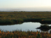
. The wetland encompasses the entire Emeryville Crescent Marsh and is named as such for its angular lunar shape.
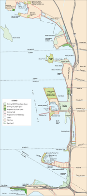
Emeryville Crescent State Marine Reserve is operated as part of Eastshore State Park
Eastshore State Park
Eastshore State Park is a state park and wildlife refuge along the San Francisco Bay shoreline of the East Bay between the cities of Richmond, Albany, Berkeley, Emeryville, and Oakland. It encompasses remnant natural wetlands, restored wetlands as well as landfill west of the Eastshore Freeway. It...
by the East Bay Regional Park District
East Bay Regional Park District
The East Bay Regional Park District is a special district operating in Alameda County and Contra Costa County, California, within the East Bay area of the San Francisco Bay Area...
.
Temescal Creek drains into the marshes near the Emeryville-Oakland border on the eastern mid-point of the marshlands. The wetlands are made up of native species of pickleweed
Pickleweed
Pickleweed is a common name used for two unrelated genera of flowering plants:*Batis, family Bataceae*Salicornia, family Amaranthaceae...
, and are currently being threatened by Spartina, a non-native invasive species of Cordgrass. It has invaded 2.4 acres (1 ha) or 2.5% of the wetlands. There is an active abatement program consisting of aquatic herbicides.
The park is often used as a recreational area by local fishers and dog-walkers. The reserve is also noted for various problem areas such as unauthorized camping, petty littering
Litter
Litter consists of waste products such as containers, papers, wrappers or faeces which have been disposed of without consent. Litter can also be used as a verb...
and dumping
Fly-tipping
Fly-tipping is a British term for dumping waste illegally instead of in an authorised rubbish dump. It is the illegal deposit of any waste onto land, i.e...
large articles garbage such as TVs and refrigerators.


