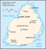
Geography of Mauritius
Encyclopedia
Climate
The local climateClimate
Climate encompasses the statistics of temperature, humidity, atmospheric pressure, wind, rainfall, atmospheric particle count and other meteorological elemental measurements in a given region over long periods...
is tropical, modified by southeast trade winds; there is a warm, dry winter from May to November and a hot, wet, and humid summer from November to May. Anti-cyclones affect the country during May to September. Cyclones affect the country during November-April. Hollanda
Cyclone Hollanda
Cyclone Hollanda was the worst tropical cyclone in Mauritius in 19 years. It formed on February 6, 1994, in the central Indian Ocean in the southern hemisphere. The cyclone moved southwestward for much of its duration, striking Mauritius on February 10 at peak intensity with winds of...
(1994) and Dina (2002) were the worst two last cyclones to have affected the island.
Statistics
Location:Southern Africa
Africa
Africa is the world's second largest and second most populous continent, after Asia. At about 30.2 million km² including adjacent islands, it covers 6% of the Earth's total surface area and 20.4% of the total land area...
, island in the Indian Ocean
Indian Ocean
The Indian Ocean is the third largest of the world's oceanic divisions, covering approximately 20% of the water on the Earth's surface. It is bounded on the north by the Indian Subcontinent and Arabian Peninsula ; on the west by eastern Africa; on the east by Indochina, the Sunda Islands, and...
, east of Madagascar
Madagascar
The Republic of Madagascar is an island country located in the Indian Ocean off the southeastern coast of Africa...
Geographic coordinates:
20°17′S 57°33′E
Map references:
World
Area (includes Agalega Islands
Agalega Islands
The Agalega Islands are two islands in the Indian Ocean, lying north of Mauritius at and are governed by that country. The islands have a total area of 24 km² , although the official figure of 70 km² appears too high when compared with data from satellite images.The North Island is home...
, Cargados Carajos Shoals (Saint Brandon), and Rodrigues
Rodrigues (island)
Rodrigues , sometimes spelled Rodriguez but named after the Portuguese explorer Diogo Rodrigues, is the smallest of the Mascarene Islands and a dependency of Mauritius...
):
total:
2,040 km²
land:
2,030 km²
water:
10 km²
Area - comparative:
almost 11 times the size of Washington, D.C.
Washington, D.C.
Washington, D.C., formally the District of Columbia and commonly referred to as Washington, "the District", or simply D.C., is the capital of the United States. On July 16, 1790, the United States Congress approved the creation of a permanent national capital as permitted by the U.S. Constitution....
Land boundaries:
0 km
Coastline:
177 km
Maritime claims:
continental shelf:
200 nmi (370.4 km; 230.2 mi) or to the edge of the continental margin
Continental margin
The continental margin is the zone of the ocean floor that separates the thin oceanic crust from thick continental crust. Continental margins constitute about 28% of the oceanic area....
exclusive economic zone:
200 nmi (370.4 km; 230.2 mi)
territorial sea:
12 nmi (22.2 km; 13.8 mi)
Terrain:
small coastal plain rising to discontinuous mountains encircling central plateau
Elevation extremes:
lowest point:
Indian Ocean 0 m
highest point:
Piton de la Petite Rivière Noire
Piton de la Petite Rivière Noire
Piton de la Petite Rivière Noire is the highest mountain on the island of Mauritius,in the Indian Ocean. Located in the Black River district and rising to a height of 828 m above sea level, it forms part of the Black River mountain range.There are two other main mountain ranges in Mauritius:...
828 m
Natural resources:
arable land, fish
Land use:
arable land:
49.26%
permanent crops:
2.96%
permanent pastures:
3%
forests and woodland:
22%
other:
23% (1993 est.)
Irrigated land:
200 km² (1998 est.)
Natural hazards:
cyclones (November to April); almost completely surrounded by reefs that may pose maritime hazards
Environment - current issues:
water pollution, degradation of coral reefs
Environment - international agreements:
party to:
Biodiversity, Climate Change, Climate Change-Kyoto Protocol, Desertification, Endangered Species, Environmental Modification, Hazardous Wastes, Law of the Sea, Marine Life Conservation, Nuclear Test Ban, Ozone Layer Protection, Ship Pollution, Wetlands
signed, but not ratified:
none of the selected agreements
Geography - note:
The main island, from which the country derives its name, is of volcanic origin and is almost entirely surrounded by coral reefs
Extreme points
This is a list of the extreme points of MauritiusMauritius
Mauritius , officially the Republic of Mauritius is an island nation off the southeast coast of the African continent in the southwest Indian Ocean, about east of Madagascar...
, the points that are farther north, south, east or west than any other location.
- Northern-most point – Tappe à Terre, North Island, Agalega IslandsAgalega IslandsThe Agalega Islands are two islands in the Indian Ocean, lying north of Mauritius at and are governed by that country. The islands have a total area of 24 km² , although the official figure of 70 km² appears too high when compared with data from satellite images.The North Island is home...
- Eastern-most point – Trou d’Argent, Rodrigues Island
- Southern-most point - Le Gris Gris, Savanne District, Mauritius
- Western-most point - North West Point, North Island, Agalega IslandsAgalega IslandsThe Agalega Islands are two islands in the Indian Ocean, lying north of Mauritius at and are governed by that country. The islands have a total area of 24 km² , although the official figure of 70 km² appears too high when compared with data from satellite images.The North Island is home...
See also
- MauritiusMauritiusMauritius , officially the Republic of Mauritius is an island nation off the southeast coast of the African continent in the southwest Indian Ocean, about east of Madagascar...
- Mauritius Travel Information (english)

