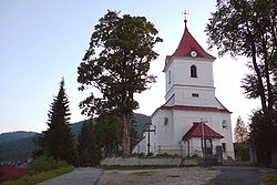
Liptovská Teplicka
Encyclopedia

Village
A village is a clustered human settlement or community, larger than a hamlet with the population ranging from a few hundred to a few thousand , Though often located in rural areas, the term urban village is also applied to certain urban neighbourhoods, such as the West Village in Manhattan, New...
and municipality
Municipality
A municipality is essentially an urban administrative division having corporate status and usually powers of self-government. It can also be used to mean the governing body of a municipality. A municipality is a general-purpose administrative subdivision, as opposed to a special-purpose district...
in Poprad District
Poprad District
Poprad District is a district inthe Prešov Region of eastern Slovakia.Until 1918, the district was almost entirely part of the Hungarian county of Spiš, apart from two small areas in the...
in the Prešov Region
Prešov Region
The Prešov Region is one of the eight Slovak administrative regions. It consists of 13 districts.-Geography:It is located in north-eastern Slovakia and has an area of 8,975 km². The region has diverse types of landscapes occurring in Slovakia, but mostly highlands and hilly lands dominate the...
of northern Slovakia
Slovakia
The Slovak Republic is a landlocked state in Central Europe. It has a population of over five million and an area of about . Slovakia is bordered by the Czech Republic and Austria to the west, Poland to the north, Ukraine to the east and Hungary to the south...
.
History
In historical recordsHistory
History is the discovery, collection, organization, and presentation of information about past events. History can also mean the period of time after writing was invented. Scholars who write about history are called historians...
the village was first mentioned in 1634.
Settled probably before 1612 when the village Pohorelá
Pohorelá
Pohorelá is a village and municipality in Brezno District, in the Banská Bystrica Region of central Slovakia.The Roman Catholic Pohorela church built in 1762 is a dominant feature of the village.-External links:* *...
(with that it shares the origins) was first mentioned in written records. The name Teplička (or its Hungarian transcript Teplicska) used till around 1920 when the adjective Liptovská (related to the Liptov
Liptov
Liptó is the name of a historic administrative county of the Kingdom of Hungary. Its territory is presently in northern Slovakia.-Geography:...
region) had been added to distinguish it from other villages with the same name in Slovakia. A new road connecting the village with Poprad
Poprad
Poprad is a city in northern Slovakia at the foot of the High Tatra Mountains famous for its picturesque historic centre and as a holiday resort. It is the biggest town of the Spiš region and the tenth largest city in Slovakia with a population of approximately 55,000.The Poprad-Tatry Airport is...
has been built after the World War II
World War II
World War II, or the Second World War , was a global conflict lasting from 1939 to 1945, involving most of the world's nations—including all of the great powers—eventually forming two opposing military alliances: the Allies and the Axis...
, and in the subsequent change of administrative divisions in 1960, the village has been integrated to the Poprad District
Poprad District
Poprad District is a district inthe Prešov Region of eastern Slovakia.Until 1918, the district was almost entirely part of the Hungarian county of Spiš, apart from two small areas in the...
of the then Eastern-Slovakian region, since 1996 Prešov Region
Prešov Region
The Prešov Region is one of the eight Slovak administrative regions. It consists of 13 districts.-Geography:It is located in north-eastern Slovakia and has an area of 8,975 km². The region has diverse types of landscapes occurring in Slovakia, but mostly highlands and hilly lands dominate the...
. (The traditional road connecting the village with the historical Liptov
Liptov
Liptó is the name of a historic administrative county of the Kingdom of Hungary. Its territory is presently in northern Slovakia.-Geography:...
region remains now inaccessible for motor cars.)
The name Teplička comes from the small creek Teplica flowing through the village that does not freeze even in the toughest winters ('teplý' means warm in Slovak language).
Geography
The municipalityMunicipality
A municipality is essentially an urban administrative division having corporate status and usually powers of self-government. It can also be used to mean the governing body of a municipality. A municipality is a general-purpose administrative subdivision, as opposed to a special-purpose district...
lies at an elevation
Elevation
The elevation of a geographic location is its height above a fixed reference point, most commonly a reference geoid, a mathematical model of the Earth's sea level as an equipotential gravitational surface ....
of 919 metres (3,015 ft) and covers an area
Area
Area is a quantity that expresses the extent of a two-dimensional surface or shape in the plane. Area can be understood as the amount of material with a given thickness that would be necessary to fashion a model of the shape, or the amount of paint necessary to cover the surface with a single coat...
of 98.69 km² (38.10 mi²). It has a population
Population
A population is all the organisms that both belong to the same group or species and live in the same geographical area. The area that is used to define a sexual population is such that inter-breeding is possible between any pair within the area and more probable than cross-breeding with individuals...
of about 2270 people.
External links
- http://www.statistics.sk/mosmis/eng/run.html
- http://www.liptovskateplicka.sk

