Pole Hill
Encyclopedia


Greater London
Greater London is the top-level administrative division of England covering London. It was created in 1965 and spans the City of London, including Middle Temple and Inner Temple, and the 32 London boroughs. This territory is coterminate with the London Government Office Region and the London...
and Essex
Essex
Essex is a ceremonial and non-metropolitan county in the East region of England, and one of the home counties. It is located to the northeast of Greater London. It borders with Cambridgeshire and Suffolk to the north, Hertfordshire to the west, Kent to the South and London to the south west...
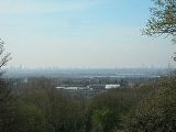
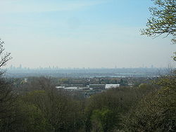
. From its summit there is an extensive view over much of East, North and West London, although in the summer the leaves of the trees in Epping Forest
Epping Forest
Epping Forest is an area of ancient woodland in south-east England, straddling the border between north-east Greater London and Essex. It is a former royal forest, and is managed by the City of London Corporation....
have a tendency to mask some of the visibility to the North and West.
Origin of name
The earliest recording of the name is as "Pouls Fee" or "Pauls Fee" in 1498. It is shown as Hawke Hill on the Chapman and André map of 1777. Hawke derives from the nearby Hawkwood. Hawk is the Old English for a nook, cranny or corner and so means wood at the corner of the parish (of ChingfordChingford
Chingford is a district of north east London, bordering on Enfield and Edmonton to the west, Woodford to the east, Walthamstow and Stratford to the south and Essex to the north. It is situated northeast of Charing Cross and forms part of the London Borough of Waltham Forest...
.)
It was named Paul because it was in the manor of Chingford Pauli, also known as Chingford St. Paul's, which belonged to St Paul's Cathedral
St Paul's Cathedral
St Paul's Cathedral, London, is a Church of England cathedral and seat of the Bishop of London. Its dedication to Paul the Apostle dates back to the original church on this site, founded in AD 604. St Paul's sits at the top of Ludgate Hill, the highest point in the City of London, and is the mother...
in London
London
London is the capital city of :England and the :United Kingdom, the largest metropolitan area in the United Kingdom, and the largest urban zone in the European Union by most measures. Located on the River Thames, London has been a major settlement for two millennia, its history going back to its...
. Fee is from the Middle English
Middle English
Middle English is the stage in the history of the English language during the High and Late Middle Ages, or roughly during the four centuries between the late 11th and the late 15th century....
fe which means a landed estate indicating it formed part of the manor. After the erection of the Greenwich Meridian Obelisk mentioned below, it appears to have acquired the cognomen of Polar Hill, but this soon dropped out of use.
Astronomical history
The hill stands in Epping ForestEpping Forest
Epping Forest is an area of ancient woodland in south-east England, straddling the border between north-east Greater London and Essex. It is a former royal forest, and is managed by the City of London Corporation....
at 0 degrees longitude, and 51 degrees 38 minutes latitude. At its highest point it is 91 metres above sea level. It is chiefly noted for the fact that it lies directly on the Greenwich meridian and, being the highest point on that bearing directly visible from Greenwich, was at one time used as a marker by geographers at the observatory
Royal Observatory, Greenwich
The Royal Observatory, Greenwich , in London, England played a major role in the history of astronomy and navigation, and is best known as the location of the prime meridian...
there to set their telescopes and observation equipment to a true zero degree bearing.
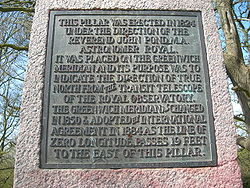
On top of the hill there are two obelisks. The larger is made of granite and bears the following inscription:
This pillar was erected in 1824 under the direction of the Reverend John Pond, MA, Astronomer RoyalAstronomer RoyalAstronomer Royal is a senior post in the Royal Household of the Sovereign of the United Kingdom. There are two officers, the senior being the Astronomer Royal dating from 22 June 1675; the second is the Astronomer Royal for Scotland dating from 1834....
. It was placed on the Greenwich Meridian and its purpose was to indicate the direction of true northTrue northTrue north is the direction along the earth's surface towards the geographic North Pole.True geodetic north usually differs from magnetic north , and from grid north...
from the transit telescope of the Royal Observatory. The Greenwich Meridian as changed in 1850 and adopted by international agreement in 1884 as the line of zero longitude passes 19 feet to the east of this pillar.
At that point (19 feet / 5.8m east) there is a smaller concrete obelisk, which marks the true modern position of the Greenwich Meridian. The pillar however was not erected to mark the meridian. It is an Ordnance Survey
Ordnance Survey
Ordnance Survey , an executive agency and non-ministerial government department of the Government of the United Kingdom, is the national mapping agency for Great Britain, producing maps of Great Britain , and one of the world's largest producers of maps.The name reflects its creation together with...
trig point
Trig point
A triangulation station, also known as a triangulation pillar, trigonometrical station, trigonometrical point, trig station, trig beacon or trig point, and sometimes informally as a trig, is a fixed surveying station, used in geodetic surveying and other surveying projects in its vicinity...
placed here to mark the top of the hill. The fact that it is on or near the Meridian is a coincidence.
Famous connections
Lawrence of ArabiaT. E. Lawrence
Lieutenant Colonel Thomas Edward Lawrence, CB, DSO , known professionally as T. E. Lawrence, was a British Army officer renowned especially for his liaison role during the Arab Revolt against Ottoman Turkish rule of 1916–18...
once owned a considerable amount of land on the western side of the hill and built himself a small hut there in which he lived for several years. Nothing remains today of this structure on Pole Hill. Lawrence's hut was demolished in 1930 and rebuilt in The Warren, Loughton. The present day residential road Arabia Close, however, sits very close by and is named (indirectly) for Lawrence.

