
Teton Dam
Encyclopedia
The Teton Dam was a federally built earthen dam on the Teton River
in southeastern Idaho
, set between Fremont and Madison counties, USA
, which when filling for the first time suffered a catastrophic failure on June 5, 1976. The collapse of the dam resulted in the deaths of 11 people
and 13,000 head of cattle. The dam cost about USD
$100 million to build, and the federal government paid over $300 million in claims related to the dam failure. Total damage estimates have ranged up to $2 billion. The dam has not been rebuilt.
, which is a broad tectonic
depression on top of rhyolitic
ash
-flow tuff
. The tuff, a late-Cenozoic
volcanic
rock
dating to about 1.9 million years, sits on top of sedimentary rock
. The area is very permeable
, highly fissured and unstable. Test boreholes, drilled by engineers and geologists employed by the Bureau of Reclamation, U.S. Department of the Interior, showed that one side of the canyon was highly fissured, a condition unlikely to be remediated by the Bureau's favoured method of "grouting" (injecting concrete into the substrates under high pressure).
The dam was completed in November 1975 and no seepage was noted on the dam itself before the date of the collapse. However, on June 3, 1976 workers found two small springs
had opened up downstream.
, which could carry just 850 cuft/s. Although the reservoir was still rising over 4 feet (1.2 m) per day, the main outlet works and spillway gates were not yet in service. The spillway gates were cordoned off by steel walls while they were being painted.
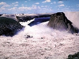
On Saturday, June 5, 1976, at 7:30 a.m., a muddy leak appeared, suggesting sediment was in the water, but engineers did not believe there was a problem. By 9:30 a.m. the downstream face of the dam had developed a wet spot erupting water at 20 cuft/s and embankment
material began to wash out. Crews with bulldozer
s were sent to plug the leak, but were unsuccessful. Local media
appeared at the site, and at 11:15 officials told the county sheriff's office to evacuate downstream residents. Work crews were forced to flee on foot as the widening gap, now over the size of a swimming pool, swallowed their equipment. The operators of two bulldozers caught in the eroding embankment were pulled to safety with ropes.
At 11:55 a.m. Mountain Daylight Time (UTC-6:00), the crest of the dam sagged and collapsed into the reservoir; two minutes later the remainder of the right-bank third of the main dam wall disintegrated. Over 2000000 cuft/s of sediment filled water emptied through the breach into the remaining 6 miles (9.7 km) of the Teton River canyon, after which the flood spread out and shallowed on the Snake River Plain. By 8:00 p.m. that evening, the reservoir had completely emptied, although over two-thirds of the dam wall remained standing.
soil used in the core and on fissured (cracked) rhyolite
in the foundations of the dam that allowed water to seep under the dam. The permeable loess was found to be cracked. It is postulated that the combination of these flaws allowed water to seep through the dam and led to internal erosion, called piping, that eventually caused the dam's collapse.
The panel had quickly identified piping as the most probable cause of the failure, then focused its efforts on determining how the piping started. Two mechanisms were possible. The first was the flow of water under highly erodible and unprotected fill, through joints in unsealed rock beneath the grout cap, and development of an erosion tunnel. The second was “cracking caused by differential strains or hydraulic fracturing of the core material.” The panel was unable to determine whether one or the other mechanism occurred, or a combination.
“The fundamental cause of failure may be regarded as a combination of geological factors and design decisions that, taken together, permitted the failure to develop.”
A wide-ranging controversy erupted from the dam's collapse. According to the Bureau of Reclamation,
, Salem, Hibbard and Rexburg
. Thousands of homes and businesses were destroyed. The small agricultural communities of Wilford and Sugar City were wiped from the river bank. Five of the fourteen deaths attributed to the flood occurred in Wilford. The similar community of Teton City, on the south bank of the river, is sited on a modest elevation and was largely spared. One Teton resident was fishing on the river at the time of the dam failure and was drowned. An elderly woman living in Teton City died as a result of the evacuation.
One estimate placed damage to Hibbard and Rexburg area, with a population of about 10,000, at 80 percent of existing structures. The Snake River flows through the industrial, commercial and residential districts of north Rexburg. A significant reason for the massive damage in the community was the location of a large commercial lumber yard directly upstream. When the flood waters hit, thousands of board feet of timber snapped from their moorings, caught fire from leaking gas, and were swept downstream. The force of the logs and cut lumber, and the subsequent fires, practically destroyed the city.
The flood waters traveled west along the route of the south fork of the Snake, around the Menan Buttes
, significantly damaging the community of Roberts
. The city of Idaho Falls
, even further down on the flood plain, had time to prepare. At the older American Falls Dam
downstream, engineers increased discharge by less than 5% before the flood arrived. That dam held, and the flood was effectively over, but tens of thousands of acres of land near the river were stripped of fertile topsoil.
The force of the Teton Dam failure destroyed the lower part of the Teton River, washing away riparian zone
s and reducing the canyon walls. This seriously damaged the stream ecology, and the native cutthroat trout
population has been endangered. The force of the water and excessive sediment also damaged stream habitat in the Snake River
and some tributaries, at least as far downstream as Fort Hall, Idaho
.
After the dam's collapse, debris clean up began immediately and took the rest of the summer. Rebuilding of damaged property continued for several years. Within a week after the disaster, President Gerald Ford
requested a $200 million appropriation for initial payments for damages, without assigning responsibility for Teton Dam’s failure.
The Bureau of Reclamation set up claims offices in Rexburg
, Idaho Falls
, and Blackfoot
. By January 4, 1977, disaster victims filed over 4,800 claims totalling $194 million. By that date, the federal government paid 3,813 of those claims, $93.5 million. Originally scheduled to end in July 1978, the claims program continued into the 1980s. At the end of the claims program in January 1987, the federal government had paid 7,563 claims for a total amount of $322 million.
Teton River (Idaho)
The Teton River is an tributary of the Henrys Fork of the Snake River in southeastern Idaho in the United States. It drains through the Teton Valley along the west side of the Teton Range along the Idaho-Wyoming border at the eastern end of the Snake River Plain...
in southeastern Idaho
Idaho
Idaho is a state in the Rocky Mountain area of the United States. The state's largest city and capital is Boise. Residents are called "Idahoans". Idaho was admitted to the Union on July 3, 1890, as the 43rd state....
, set between Fremont and Madison counties, USA
United States
The United States of America is a federal constitutional republic comprising fifty states and a federal district...
, which when filling for the first time suffered a catastrophic failure on June 5, 1976. The collapse of the dam resulted in the deaths of 11 people
and 13,000 head of cattle. The dam cost about USD
United States dollar
The United States dollar , also referred to as the American dollar, is the official currency of the United States of America. It is divided into 100 smaller units called cents or pennies....
$100 million to build, and the federal government paid over $300 million in claims related to the dam failure. Total damage estimates have ranged up to $2 billion. The dam has not been rebuilt.
Geology
The dam site is located in the eastern Snake River PlainSnake River Plain
The Snake River Plain is a geologic feature located primarily within the state of Idaho in the United States of America. It stretches about westward from northwest of the state of Wyoming to the Idaho-Oregon border. The plain is a wide flat bow-shaped depression, and covers about a quarter of Idaho...
, which is a broad tectonic
Tectonics
Tectonics is a field of study within geology concerned generally with the structures within the lithosphere of the Earth and particularly with the forces and movements that have operated in a region to create these structures.Tectonics is concerned with the orogenies and tectonic development of...
depression on top of rhyolitic
Rhyolite
This page is about a volcanic rock. For the ghost town see Rhyolite, Nevada, and for the satellite system, see Rhyolite/Aquacade.Rhyolite is an igneous, volcanic rock, of felsic composition . It may have any texture from glassy to aphanitic to porphyritic...
ash
Volcanic ash
Volcanic ash consists of small tephra, which are bits of pulverized rock and glass created by volcanic eruptions, less than in diameter. There are three mechanisms of volcanic ash formation: gas release under decompression causing magmatic eruptions; thermal contraction from chilling on contact...
-flow tuff
Tuff
Tuff is a type of rock consisting of consolidated volcanic ash ejected from vents during a volcanic eruption. Tuff is sometimes called tufa, particularly when used as construction material, although tufa also refers to a quite different rock. Rock that contains greater than 50% tuff is considered...
. The tuff, a late-Cenozoic
Cenozoic
The Cenozoic era is the current and most recent of the three Phanerozoic geological eras and covers the period from 65.5 mya to the present. The era began in the wake of the Cretaceous–Tertiary extinction event at the end of the Cretaceous that saw the demise of the last non-avian dinosaurs and...
volcanic
Volcano
2. Bedrock3. Conduit 4. Base5. Sill6. Dike7. Layers of ash emitted by the volcano8. Flank| 9. Layers of lava emitted by the volcano10. Throat11. Parasitic cone12. Lava flow13. Vent14. Crater15...
rock
Rock (geology)
In geology, rock or stone is a naturally occurring solid aggregate of minerals and/or mineraloids.The Earth's outer solid layer, the lithosphere, is made of rock. In general rocks are of three types, namely, igneous, sedimentary, and metamorphic...
dating to about 1.9 million years, sits on top of sedimentary rock
Sedimentary rock
Sedimentary rock are types of rock that are formed by the deposition of material at the Earth's surface and within bodies of water. Sedimentation is the collective name for processes that cause mineral and/or organic particles to settle and accumulate or minerals to precipitate from a solution....
. The area is very permeable
Permeability (fluid)
Permeability in fluid mechanics and the earth sciences is a measure of the ability of a porous material to allow fluids to pass through it.- Units :...
, highly fissured and unstable. Test boreholes, drilled by engineers and geologists employed by the Bureau of Reclamation, U.S. Department of the Interior, showed that one side of the canyon was highly fissured, a condition unlikely to be remediated by the Bureau's favoured method of "grouting" (injecting concrete into the substrates under high pressure).
The dam was completed in November 1975 and no seepage was noted on the dam itself before the date of the collapse. However, on June 3, 1976 workers found two small springs
Spring (hydrosphere)
A spring—also known as a rising or resurgence—is a component of the hydrosphere. Specifically, it is any natural situation where water flows to the surface of the earth from underground...
had opened up downstream.
The collapse and flood
At the time of the collapse, spring runoff had almost filled the new reservoir to capacity, with a maximum depth of 240 feet (73.2 m). Water began seeping from the dam on the Thursday before the collapse, an event not unexpected for an earthen dam. The only structure that had been initially prepared for releasing water was the emergency outlet worksOutlet works
A set of outlet works is a device used to release and regulate water flow from a dam. Such devices usually consist of one or more pipes or tunnels through the embankment of the dam, directing water usually under high pressure to the river downstream...
, which could carry just 850 cuft/s. Although the reservoir was still rising over 4 feet (1.2 m) per day, the main outlet works and spillway gates were not yet in service. The spillway gates were cordoned off by steel walls while they were being painted.
On Saturday, June 5, 1976, at 7:30 a.m., a muddy leak appeared, suggesting sediment was in the water, but engineers did not believe there was a problem. By 9:30 a.m. the downstream face of the dam had developed a wet spot erupting water at 20 cuft/s and embankment
Embankment dam
An embankment dam is a massive artificial water barrier. It is typically created by the emplacement and compaction of a complex semi-plastic mound of various compositions of soil, sand, clay and/or rock. It has a semi-permanent waterproof natural covering for its surface, and a dense, waterproof...
material began to wash out. Crews with bulldozer
Bulldozer
A bulldozer is a crawler equipped with a substantial metal plate used to push large quantities of soil, sand, rubble, etc., during construction work and typically equipped at the rear with a claw-like device to loosen densely-compacted materials.Bulldozers can be found on a wide range of sites,...
s were sent to plug the leak, but were unsuccessful. Local media
Mass media
Mass media refers collectively to all media technologies which are intended to reach a large audience via mass communication. Broadcast media transmit their information electronically and comprise of television, film and radio, movies, CDs, DVDs and some other gadgets like cameras or video consoles...
appeared at the site, and at 11:15 officials told the county sheriff's office to evacuate downstream residents. Work crews were forced to flee on foot as the widening gap, now over the size of a swimming pool, swallowed their equipment. The operators of two bulldozers caught in the eroding embankment were pulled to safety with ropes.
At 11:55 a.m. Mountain Daylight Time (UTC-6:00), the crest of the dam sagged and collapsed into the reservoir; two minutes later the remainder of the right-bank third of the main dam wall disintegrated. Over 2000000 cuft/s of sediment filled water emptied through the breach into the remaining 6 miles (9.7 km) of the Teton River canyon, after which the flood spread out and shallowed on the Snake River Plain. By 8:00 p.m. that evening, the reservoir had completely emptied, although over two-thirds of the dam wall remained standing.
Cause of the collapse
Study of the dam's environment and structure placed blame on the collapse on the permeable loessLoess
Loess is an aeolian sediment formed by the accumulation of wind-blown silt, typically in the 20–50 micrometre size range, twenty percent or less clay and the balance equal parts sand and silt that are loosely cemented by calcium carbonate...
soil used in the core and on fissured (cracked) rhyolite
Rhyolite
This page is about a volcanic rock. For the ghost town see Rhyolite, Nevada, and for the satellite system, see Rhyolite/Aquacade.Rhyolite is an igneous, volcanic rock, of felsic composition . It may have any texture from glassy to aphanitic to porphyritic...
in the foundations of the dam that allowed water to seep under the dam. The permeable loess was found to be cracked. It is postulated that the combination of these flaws allowed water to seep through the dam and led to internal erosion, called piping, that eventually caused the dam's collapse.
The panel had quickly identified piping as the most probable cause of the failure, then focused its efforts on determining how the piping started. Two mechanisms were possible. The first was the flow of water under highly erodible and unprotected fill, through joints in unsealed rock beneath the grout cap, and development of an erosion tunnel. The second was “cracking caused by differential strains or hydraulic fracturing of the core material.” The panel was unable to determine whether one or the other mechanism occurred, or a combination.
“The fundamental cause of failure may be regarded as a combination of geological factors and design decisions that, taken together, permitted the failure to develop.”
A wide-ranging controversy erupted from the dam's collapse. According to the Bureau of Reclamation,
Deaths, damage and property claims
Teton Canyon comes to an end approximately six miles below the dam site, where the river flows into the Snake River Plain. When the dam failed, the freed waters struck several communities immediately downstream, particularly Wilford at the terminus of the canyon, Sugar CitySugar City, Idaho
Sugar City is a city in Madison County, Idaho, United States. The population was 1,242 at the 2000 census. It is part of the Rexburg, Idaho Micropolitan Statistical Area.-History:...
, Salem, Hibbard and Rexburg
Rexburg, Idaho
-Demographics:As of the census of 2000, there were 17,257 people, 4,274 households, and 2,393 families residing in the city. The population density was 3,534.4 people per square mile . There were 4,533 housing units at an average density of 928.4 per square mile...
. Thousands of homes and businesses were destroyed. The small agricultural communities of Wilford and Sugar City were wiped from the river bank. Five of the fourteen deaths attributed to the flood occurred in Wilford. The similar community of Teton City, on the south bank of the river, is sited on a modest elevation and was largely spared. One Teton resident was fishing on the river at the time of the dam failure and was drowned. An elderly woman living in Teton City died as a result of the evacuation.
One estimate placed damage to Hibbard and Rexburg area, with a population of about 10,000, at 80 percent of existing structures. The Snake River flows through the industrial, commercial and residential districts of north Rexburg. A significant reason for the massive damage in the community was the location of a large commercial lumber yard directly upstream. When the flood waters hit, thousands of board feet of timber snapped from their moorings, caught fire from leaking gas, and were swept downstream. The force of the logs and cut lumber, and the subsequent fires, practically destroyed the city.
The flood waters traveled west along the route of the south fork of the Snake, around the Menan Buttes
Menan Buttes
The North and South Menan Buttes in southeastern Idaho are two of the world's largest volcanic tuff cones. The two cones, with four smaller associated cones, align along a north-northwest line and comprise the Menan Complex. The buttes rise about 800 feet above the surrounding Snake River plain...
, significantly damaging the community of Roberts
Roberts, Idaho
Roberts is a city in Jefferson County, Idaho, United States. It is part of the Idaho Falls, Idaho Metropolitan Statistical Area. The population was 647 at the 2000 census.-Geography:Roberts is located at ....
. The city of Idaho Falls
Idaho Falls, Idaho
Idaho Falls is a city in and the county seat of Bonneville County, Idaho, United States, and the largest city in Eastern Idaho. As of the 2010 census, the population of Idaho Falls was 56,813, with a metro population of 130,374....
, even further down on the flood plain, had time to prepare. At the older American Falls Dam
American Falls Dam
The American Falls Dam is a concrete gravity-type dam located near the town of American Falls, Idaho, on river mile 714.7 of the Snake River. The dam and reservoir are a part of the Minidoka Project on the Snake River Plain and are used primarily for flood control, irrigation, and recreation...
downstream, engineers increased discharge by less than 5% before the flood arrived. That dam held, and the flood was effectively over, but tens of thousands of acres of land near the river were stripped of fertile topsoil.
The force of the Teton Dam failure destroyed the lower part of the Teton River, washing away riparian zone
Riparian zone
A riparian zone or riparian area is the interface between land and a river or stream. Riparian is also the proper nomenclature for one of the fifteen terrestrial biomes of the earth. Plant habitats and communities along the river margins and banks are called riparian vegetation, characterized by...
s and reducing the canyon walls. This seriously damaged the stream ecology, and the native cutthroat trout
Cutthroat trout
The cutthroat trout is a species of freshwater fish in the salmon family of order Salmoniformes. It is one of the many fish species colloquially known as trout...
population has been endangered. The force of the water and excessive sediment also damaged stream habitat in the Snake River
Snake River
The Snake is a major river of the greater Pacific Northwest in the United States. At long, it is the largest tributary of the Columbia River, the largest North American river that empties into the Pacific Ocean...
and some tributaries, at least as far downstream as Fort Hall, Idaho
Fort Hall, Idaho
Fort Hall is a census-designated place in the southeastern part of the U.S. state of Idaho, split between northern Bannock County and southern Bingham County. It is located on the Fort Hall Indian Reservation along the Snake River north of Pocatello, near the site of the original Fort Hall in the...
.
After the dam's collapse, debris clean up began immediately and took the rest of the summer. Rebuilding of damaged property continued for several years. Within a week after the disaster, President Gerald Ford
Gerald Ford
Gerald Rudolph "Jerry" Ford, Jr. was the 38th President of the United States, serving from 1974 to 1977, and the 40th Vice President of the United States serving from 1973 to 1974...
requested a $200 million appropriation for initial payments for damages, without assigning responsibility for Teton Dam’s failure.
The Bureau of Reclamation set up claims offices in Rexburg
Rexburg, Idaho
-Demographics:As of the census of 2000, there were 17,257 people, 4,274 households, and 2,393 families residing in the city. The population density was 3,534.4 people per square mile . There were 4,533 housing units at an average density of 928.4 per square mile...
, Idaho Falls
Idaho Falls, Idaho
Idaho Falls is a city in and the county seat of Bonneville County, Idaho, United States, and the largest city in Eastern Idaho. As of the 2010 census, the population of Idaho Falls was 56,813, with a metro population of 130,374....
, and Blackfoot
Blackfoot, Idaho
Blackfoot is a city in Bingham County, Idaho, United States. The population was 10,419 at the 2000 census. The city is the county seat of Bingham County. Blackfoot is self-designated the "Potato Capital of the World", because it claims to have the largest potato industry in the world...
. By January 4, 1977, disaster victims filed over 4,800 claims totalling $194 million. By that date, the federal government paid 3,813 of those claims, $93.5 million. Originally scheduled to end in July 1978, the claims program continued into the 1980s. At the end of the claims program in January 1987, the federal government had paid 7,563 claims for a total amount of $322 million.
Possible reconstruction
No plans were made for rebuilding the Teton Dam, but its reconstruction has been brought up on at least one occasion.External links
- Bureau of Reclamation overview with photos, and link to final report
- The Teton Basin Project, Eric A. Stene, Bureau of Reclamation History Program, 1996
- "The Bureau That Changed the West" One That Got Away: Teton Dam (site critical of USBR)
- Teton Dam Flood Museum, Rexburg, Idaho
- Teton Dam Collection – Oral History reports and newspaper articles, includes more than 50 oral history interviews of those living in the area when the disaster occurred.
- Images showing progressive dam erosion damage, taken at the time by Mrs. Eunice Olson
- Data from American Falls Dam (downstream) from the Teton Dam Failure
- Teton Dam Failure Case Study, engineering case study, University of Alabama at Birmingham