What are the names of Areas and Streets in Malabo
replied to: REXALBERT
Replied to: What are the names of Areas and Streets in Malabo...
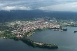
Satellite view is showing Malabo, the national capital of Equatorial Guinea, located on the northern coast of Bioko Island (formerly Fernando Póo).
Malabo has a city population of about 100 000 inhabitants. Spoken languages are Spanish (official) and local Niger–Congo languages, pidgin.
To view just the map, click on the "Map" button.
The map shows a city map of Malabo with expressways, main roads and streets, zoom out to find the location of Malabo International Airport (IATA code: SSG), at Punta Europa about 10 km (6 mi) west of the city.
replied to: drsalman764
Replied to: Satellite view is showing Malabo, the national capital of Equatorial...
Thanks for your answer.
I would like to have more than that. Those street I suppose have names. Also I want to confirm if there is officially an area or street called "Los Ageles" in Malabo.