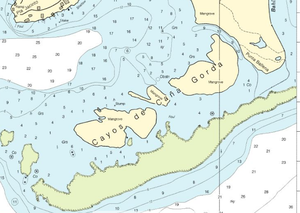
Cayos de Caña Gorda
Encyclopedia


Mangrove
Mangroves are various kinds of trees up to medium height and shrubs that grow in saline coastal sediment habitats in the tropics and subtropics – mainly between latitudes N and S...
-covered cay
Cay
A cay , also spelled caye or key, is a small, low-elevation, sandy island formed on the surface of coral reefs. Cays occur in tropical environments throughout the Pacific, Atlantic and Indian Oceans , where they provide habitable and agricultural land for hundreds of thousands of people...
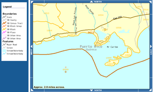
s, located at 17°56′32"N 066°52′17"W off the southwestern coast of Puerto Rico
Puerto Rico
Puerto Rico , officially the Commonwealth of Puerto Rico , is an unincorporated territory of the United States, located in the northeastern Caribbean, east of the Dominican Republic and west of both the United States Virgin Islands and the British Virgin Islands.Puerto Rico comprises an...
. They belong to barrio
Barrio
Barrio is a Spanish word meaning district or neighborhood.-Usage:In its formal usage in English, barrios are generally considered cohesive places, sharing, for example, a church and traditions such as feast days...
Caranero of Guánica
Guánica, Puerto Rico
Guánica is a municipality in southwestern Puerto Rico located on southern coast, bordering the Caribbean Sea, south of Sabana Grande, east of Lajas, and west of Yauco. It is part of the Yauco Metropolitan Statistical Area....
municipio
Municipio
Municipio and Município are terms used for country subdivisions. They are often translated as municipality.-Overview:...
. The eastern cay, Isla Ballena is separated from the Puerto Rican mainland close to Punta Ballena only by a 20 m wide channel. The western cay, also called Gilligan's Island
Gilligan's Island
Gilligan's Island is an American television series created and produced by Sherwood Schwartz and originally produced by United Artists Television. The situation comedy series featured Bob Denver; Alan Hale, Jr.; Jim Backus; Natalie Schafer; Tina Louise; Russell Johnson; and Dawn Wells. It aired for...
(after the TV series
Gilligan's Island
Gilligan's Island is an American television series created and produced by Sherwood Schwartz and originally produced by United Artists Television. The situation comedy series featured Bob Denver; Alan Hale, Jr.; Jim Backus; Natalie Schafer; Tina Louise; Russell Johnson; and Dawn Wells. It aired for...
), or Cayo Aurora, is served by boat (600 m from the mainland at Punta Jacinto) and has public beaches. Between the two is Cayo Honda, the central cay. The total land area is 0.18 km² (177,606 m², Block
Census block
A census block is the smallest geographic unit used by the United States Census Bureau for tabulation of 100-percent data . Several blocks make up block groups, which again make up census tracts. There are on average about 39 blocks per block group, but there are variations...
1069, Block Group
Census block group
A census block group is a geographical unit used by the United States Census Bureau which is between the census tract and the census block. It is the smallest geographical unit for which the bureau publishes sample data, i.e data which is only collected from a fraction of all households.Census...
1, Census tract
Census tract
A census tract, census area, or census district is a geographic region defined for the purpose of taking a census. Usually these coincide with the limits of cities, towns or other administrative areas and several tracts commonly exist within a county...
9611, Guánica Municipio, Puerto Rico).

