
D'Aguilar Range
Encyclopedia
The D'Aguilar Range is a mountain range
near Brisbane
, Queensland
, Australia
. The town of Dayboro
is situated on the lower foothills midway along the range and Woodford
lies at the northern most point of the range. Many residential areas line its eastern slopes including the town of Samford
and the Brisbane suburb of Ferny Hills
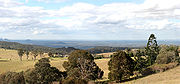
. In the west, numerous ridges and gullies are heavily forested and designated as state forest or national park.
 The D'Aguilar Range stretches from Caboolture
45 kilometres north of Brisbane
, Queensland
, through to Brisbane, where part of the D'Aguilar Range is covered by a protected parkland called the Brisbane Forest Park
.
 Mountains in the range include Camp Mountain
, Mount Nebo
, Mount Pleasant
, Mount Glorious
, Mount Samson
and Mount Mee
. Directly to the south in the west of Brisbane is the Taylor Range, sometimes considered an eastern spur of the D'Aguilar Range. Further north, highly visible from the D'Aguilar Ranges, are the Glass House Mountains.
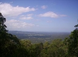
Mount D'Aguilar at 750 m above sea level is the second highest peak in the range. The highest point is Tenison Woods Mountain at 770 m. This peak is not distinct and is not marked on old maps. The Congregation of the Sisters of Perpetual Adoration created a plaque on the summit to commemorate the naming of the mountain in 1974. The year also marked the centenary of their order which was founded by J.E. Tenison Woods. Mermaid Mountain is the highest point in the southern sections at 396 m in elevation. Well known lookouts on the range include McAfee's Lookout and Jolly's Lookout, both of which have views east across to Moreton Bay
.
, including Lake Kurwongbah
, South Pine River
and Caboolture River
s flow from the range towards the east. To the north and west are the Stanley River
and tributaries that flow directly into the Somerset Dam and Wivenhoe Dam
catchments. In the southern parts of the range Enoggera Creek
, which is dammed by the Enoggera Dam
, flows to the east. Gold Creek in the same area flows south into Moggill Creek after being dammed by the Gold Creek Reservoir. Further to the west is Cabbage Tree Creek and the reservoir known as Lake Manchester.
, silky oak and black bean.
Mountain range
A mountain range is a single, large mass consisting of a succession of mountains or narrowly spaced mountain ridges, with or without peaks, closely related in position, direction, formation, and age; a component part of a mountain system or of a mountain chain...
near Brisbane
Brisbane
Brisbane is the capital and most populous city in the Australian state of Queensland and the third most populous city in Australia. Brisbane's metropolitan area has a population of over 2 million, and the South East Queensland urban conurbation, centred around Brisbane, encompasses a population of...
, Queensland
Queensland
Queensland is a state of Australia, occupying the north-eastern section of the mainland continent. It is bordered by the Northern Territory, South Australia and New South Wales to the west, south-west and south respectively. To the east, Queensland is bordered by the Coral Sea and Pacific Ocean...
, Australia
Australia
Australia , officially the Commonwealth of Australia, is a country in the Southern Hemisphere comprising the mainland of the Australian continent, the island of Tasmania, and numerous smaller islands in the Indian and Pacific Oceans. It is the world's sixth-largest country by total area...
. The town of Dayboro
Dayboro, Queensland
Dayboro is a town in the Moreton Bay Region, approximately 46 km north-northwest of Brisbane, the state capital of Queensland, Australia.To the north of Dayboro lies the D'Aguilar Range and the mountain township of Mount Mee. Other nearby towns include Petrie and Samford. The land surrounding...
is situated on the lower foothills midway along the range and Woodford
Woodford, Queensland
Woodford is a small town in Queensland, Australia, on the D'Aguilar Highway 72 km north-west of Brisbane and 24 km west of Caboolture. Its Local Government Area is the Moreton Bay Region. The town is noted for its folk festival that takes place over the New Year holidays. The Woodford...
lies at the northern most point of the range. Many residential areas line its eastern slopes including the town of Samford
Samford, Queensland
Samford is a valley community located in South East Queensland, Australia. It is roughly 21 km north west of Brisbane. The hilly area was first settled in the mid 1850s. The community is well catered for, with a number of sporting facilities, parks and museums.-Location:Samford is one of the...
and the Brisbane suburb of Ferny Hills
Ferny Hills, Queensland
Ferny Hills is an outer suburb north-west of Brisbane, Australia, and is located along Samford Road at the edge of the Brisbane Forest Park. Its local government area is the Moreton Bay Region.Ferny Hills is almost entirely a residential suburb...
. In the west, numerous ridges and gullies are heavily forested and designated as state forest or national park.
Mountains
Caboolture, Queensland
Caboolture is an urban centre approximately north of Brisbane, the state capital of Queensland, Australia. Caboolture is considered to be the northernmost urban area of the greater Brisbane metropolitan region within South East Queensland, and it marks the end of the Brisbane suburban commuter...
45 kilometres north of Brisbane
Brisbane
Brisbane is the capital and most populous city in the Australian state of Queensland and the third most populous city in Australia. Brisbane's metropolitan area has a population of over 2 million, and the South East Queensland urban conurbation, centred around Brisbane, encompasses a population of...
, Queensland
Queensland
Queensland is a state of Australia, occupying the north-eastern section of the mainland continent. It is bordered by the Northern Territory, South Australia and New South Wales to the west, south-west and south respectively. To the east, Queensland is bordered by the Coral Sea and Pacific Ocean...
, through to Brisbane, where part of the D'Aguilar Range is covered by a protected parkland called the Brisbane Forest Park
Brisbane Forest Park, Queensland
Brisbane Forest Park , is located on parts of the D'Aguilar Range. The large nature reserve lies on the western boundary of Brisbane, Queensland, Australia, in Enoggera Reservoir, adjacent to The Gap and between the Mount Coot-tha Reserve on the Taylor Range and higher peaks to the north...
.
Camp Mountain, Queensland
Camp Mountain is a rural locality northwest of Brisbane, Queensland, Australia, near Samford. It is 20 km north-west of the Brisbane central business district...
, Mount Nebo
Mount Nebo (Queensland)
Mount Nebo is a mountain approximately 28 km north of the Brisbane suburb of The Gap in Queensland, Australia. It is part of the D'Aguilar Range which includes other mountains such as Mount Pleasant, Mount Glorious and Mount Mee. The town of Mount Nebo is named after the mountain on which it...
, Mount Pleasant
Mount Pleasant (Queensland)
Mount Pleasant, is a mountain which is a part of the D'Aguilar Range.Other mountains in the D'Aguilar Range include Mount Nebo, Mount Glorious and Mount Mee.-External links:*...
, Mount Glorious
Mount Glorious (Queensland)
Mount Glorious in Queensland is a mountain which is part of the D'Aguilar Range and is a suburb in Moreton Bay Region roughly 30 km north west of Brisbane....
, Mount Samson
Mount Samson, Queensland
Mount Samson is about half way between Samford and Dayboro located in South East Queensland, Australia. It is roughly 34 km north west of Brisbane. It is located in the local government area of Moreton Bay Region...
and Mount Mee
Mount Mee, Queensland
Mount Mee is a suburb and mountain in Queensland, Australia, located north of the town of Dayboro on the D'Aguilar Range.-History:The area around Mount Mee was known to the indigenous inhabitants of the area as Dahmongah, a word meaning "flying squirrel" or glider...
. Directly to the south in the west of Brisbane is the Taylor Range, sometimes considered an eastern spur of the D'Aguilar Range. Further north, highly visible from the D'Aguilar Ranges, are the Glass House Mountains.
Mount D'Aguilar at 750 m above sea level is the second highest peak in the range. The highest point is Tenison Woods Mountain at 770 m. This peak is not distinct and is not marked on old maps. The Congregation of the Sisters of Perpetual Adoration created a plaque on the summit to commemorate the naming of the mountain in 1974. The year also marked the centenary of their order which was founded by J.E. Tenison Woods. Mermaid Mountain is the highest point in the southern sections at 396 m in elevation. Well known lookouts on the range include McAfee's Lookout and Jolly's Lookout, both of which have views east across to Moreton Bay
Moreton Bay
Moreton Bay is a bay on the eastern coast of Australia 45 km from Brisbane, Queensland. It is one of Queensland's most important coastal resources...
.
Catchments
The North Pine RiverNorth Pine River
North Pine River flows from the D'Aguilar Range in the Mount Mee State Forest, approximately 50 km north-west of Brisbane, to its convergence with South Pine River at Lawnton, Queensland, Australia.-History:...
, including Lake Kurwongbah
Lake Kurwongbah
Lake Kurwongbah is a potable water supply for urban areas in Moreton Bay in Queensland, Australia. Its catchment adjoins the localities of Petrie, Kallangur and Dakabin. To the east of the lake is the Lakeside Raceway....
, South Pine River
South Pine River
South Pine River flows from the foothills of Mount Glorious, north-west of Brisbane City, to its convergence with North Pine River at Lawnton, Queensland Australia.On early maps the river was called Eden River...
and Caboolture River
Caboolture River
The Caboolture River is a small river in South East Queensland. It rises in the D'Aguilar Range near Ocean View and flows through Caboolture and Morayfield before entering Deception Bay at Beachmere....
s flow from the range towards the east. To the north and west are the Stanley River
Stanley River (Queensland)
The Stanley River in Queensland is the main tributary of the Brisbane River. The Stanley River valley extends roughly 35 km westwards from the area south of Maleny to Kilcoy before veering southwards....
and tributaries that flow directly into the Somerset Dam and Wivenhoe Dam
Wivenhoe Dam
Wivenhoe Dam is a dam across the Brisbane River a little way upstream from Locker Creek. The dam creates the artificial Lake Wivenhoe. The dam wall is located about by road from the centre of Brisbane, Queensland, Australia....
catchments. In the southern parts of the range Enoggera Creek
Enoggera Creek
Enoggera Creek is a waterway that rises on the D'Aguilar Range and flows into the Brisbane River. The creek's headwaters form on the southern slopes of Mount Nebo in Brisbane Forest Park....
, which is dammed by the Enoggera Dam
Enoggera Dam
The Enoggera Dam, which is located within the inner, western suburb of Enoggera Reservoir, in Brisbane, Queensland, and was constructed in 1866. It was built on Enoggera Creek and was the first major dam built in Queensland...
, flows to the east. Gold Creek in the same area flows south into Moggill Creek after being dammed by the Gold Creek Reservoir. Further to the west is Cabbage Tree Creek and the reservoir known as Lake Manchester.
Industry
Timber logging on the range was instrumental in the development of Dayboro. Operations expanded in the 1870s as loggers removed hoop pine, cedarToona ciliata
Australian Red Cedar , Toona ciliata is a forest tree in the family Meliaceae which grows throughout southern Asia from Afghanistan to Papua New Guinea and Australia. In Australia its natural habitat is now extensively cleared subtropical rainforests of New South Wales and Queensland...
, silky oak and black bean.