Durdové
Encyclopedia

Village
A village is a clustered human settlement or community, larger than a hamlet with the population ranging from a few hundred to a few thousand , Though often located in rural areas, the term urban village is also applied to certain urban neighbourhoods, such as the West Village in Manhattan, New...
and municipality
Municipality
A municipality is essentially an urban administrative division having corporate status and usually powers of self-government. It can also be used to mean the governing body of a municipality. A municipality is a general-purpose administrative subdivision, as opposed to a special-purpose district...
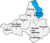
in Považská Bystrica District
Považská Bystrica District
Považská Bystrica District is adistrict inthe Trenčín Region of western Slovakia.Until 1918, the district was part of theHungarian countyof Trenčín.-Municipalities:*Bodiná*Brvnište*Čelkova Lehota*Dolná Mariková...
in the Trenčín Region
Trencín Region
The Trenčín Region is one of the eight Slovak administrative regions. It consists of 9 districts .-Geography:It is located in the north-western Slovakia, has an area of 4,502 km² and a population of 600,386 . The Danubian Lowland reaches the region to Nové Mesto nad Váhom and Partizánske areas...
of north-western Slovakia
Slovakia
The Slovak Republic is a landlocked state in Central Europe. It has a population of over five million and an area of about . Slovakia is bordered by the Czech Republic and Austria to the west, Poland to the north, Ukraine to the east and Hungary to the south...
.
Geography
The municipalityMunicipality
A municipality is essentially an urban administrative division having corporate status and usually powers of self-government. It can also be used to mean the governing body of a municipality. A municipality is a general-purpose administrative subdivision, as opposed to a special-purpose district...
lies at an elevation
Elevation
The elevation of a geographic location is its height above a fixed reference point, most commonly a reference geoid, a mathematical model of the Earth's sea level as an equipotential gravitational surface ....
of 381 metres (1,250 ft) and covers an area of 4.815 km² (1.859 mi²). It has a population of about 192.
External links
- http://www.statistics.sk/mosmis/eng/run.html

