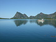
Engeløya
Encyclopedia

Steigen
Steigen is a municipality in Nordland county, Norway. It is part of the Salten traditional region. The administrative centre of the municipality is the village of Leinesfjord....
municipality, Nordland
Nordland
is a county in Norway in the North Norway region, bordering Troms in the north, Nord-Trøndelag in the south, Norrbottens län in Sweden to the east, Västerbottens län to the southeast, and the Atlantic Ocean to the west. The county was formerly known as Nordlandene amt. The county administration is...
county, Norway. The island has an area of 69 km². Engeløya translates into English
English language
English is a West Germanic language that arose in the Anglo-Saxon kingdoms of England and spread into what was to become south-east Scotland under the influence of the Anglian medieval kingdom of Northumbria...
as "Angel Island". The highest point is Trohornet at 649 m.
Transportation
Engeløya has road connection to the mainland using the Engeløy BridgesEngeløy Bridges
The Engeløy Bridges are two bridges that connect Engeløya in Nordland county in Norway to the mainland.The high bridge goes from the mainland to Ålstadøya. It is a cantilever bridge. It is 548 metres long, with a longest span of 110 metres....
.
There is an airport
Engeløy Airport, Grådussan
Engeløy Airport, Grådussan is an airport located on the northwest tip of Engeløya, an island in Steigen municipality, Nordland county, Norway....
located on the northwest tip of the island.

