

Heerstraße (Berlin)
Encyclopedia

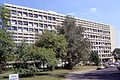
Theodor-Heuss-Platz
The Theodor-Heuss-Platz is a big square in Berlin. It's located in the locality of Westend in the Charlottenburg-Wilmersdorf district...
in Berlin-Charlottenburg
Charlottenburg
Charlottenburg is a locality of Berlin within the borough of Charlottenburg-Wilmersdorf, named after Queen consort Sophia Charlotte...
until the western city border of Berlin in the locality of Staaken
Staaken
Staaken is a locality at the western rim of Berlin within the borough of Spandau. In the west it shares border with the Brandenburg municipalities of Falkensee and Dallgow-Döberitz in the Havelland district. Buildings range from small detached houses in the west to larger 1960s and 1970s housing...
in the borough of Spandau
Spandau
Spandau is the fifth of the twelve boroughs of Berlin. It is the fourth largest and westernmost borough, situated at the confluence of the Havel and Spree rivers and along the western bank of the Havel, but the least populated.-Overview:...
. In its intire length it is part of the Bundesstraße 5
Bundesstraße 5
The Bundesstraße 5 or B5 is a German federal highway running in a northwesterly to southeasterly direction from the Danish border near Niebüll to Frankfurt . It provides a direct route for motorists traveling between Berlin and Hamburg. In Berlin B5 forms among others the following squares and...
; from Theodor-Heuss-Platz to Wilhelmstraße
Wilhelmstraße (Spandau)
The Wilhelmstraße in the Berliner district of Spandau is the connecting street between Spandau and Potsdam. In the north, at Seeburger Straße and the Ziegelhof, the Wilhelmstraße runs into the Klosterstraße, about a kilometre south of Spandau Station....
it is also Bundesstraße 2. With its length of about 10 kilometres, it is one of the longest streets in Berlin
Berlin
Berlin is the capital city of Germany and is one of the 16 states of Germany. With a population of 3.45 million people, Berlin is Germany's largest city. It is the second most populous city proper and the seventh most populous urban area in the European Union...
and an important commuter route.
Planning and construction
The construction of the street started in 1874 as chaussee from Berlin-CharlottenburgCharlottenburg
Charlottenburg is a locality of Berlin within the borough of Charlottenburg-Wilmersdorf, named after Queen consort Sophia Charlotte...
to Pichelsberg. In 1911 the street was opened in full length as Döberitzer Heerstraße in attendance of Emperor Wilhelm II.. It was constructed in stages since 1903. This all was in connection with the construction of a wide street for representation purposes, which started at the Berlin Castle as Unter den Linden
Unter den Linden
Unter den Linden is a boulevard in the Mitte district of Berlin, the capital of Germany. It is named for its linden trees that line the grassed pedestrian mall between two carriageways....
Street to Ernst-Reuter-Platz. It was then extended via Bismarckstraße and Kaiserdamm with a slight bent at Scholzplatz. From 1920 on the name was shortened to Heerstraße.
Till 1964 the Heerstraße was also a tram route. The former tramway
Tramway track
Tramway track is used on tramways or light rail operations. Grooved rails are often used in order to make street running feasible...
is today's green strip between Theodor-Heuss-Platz and Stößenseebrücke.
Theodor-Heuss-Platz to S-Bahnhof Heerstraße
The Heerstraße starts at Theodor-Heuss-Platz in Westend of CharlottenburgCharlottenburg
Charlottenburg is a locality of Berlin within the borough of Charlottenburg-Wilmersdorf, named after Queen consort Sophia Charlotte...
district, close to the exhibition ground
Messe Berlin
Messe Berlin fairgrounds are situated in Berlin-Westend, precinct Charlottenburg-Wilmersdorf, at Masurenallee opposite of the Haus des Rundfunks....
, the Funkturm
Funkturm Berlin
The Berliner Funkturm or Funkturm Berlin is a transmitting tower in Berlin, built between 1924 and 1926 by Heinrich Straumer. It is nicknamed "der lange Lulatsch" and is one of the best-known points of interest in the city of Berlin. It stands in the Berlin trade fair ground in the...
and the International Congress Centre (ICC).
In east-west direction it got houses till the S-Bahnhof Heerstraße. Until 30 March 1950 this part of the Heerstraße was still known as Kaiserdamm.
S-Bahnhof Heerstraße to Scholzplatz
British Military Hospital
This may refer to a number of establishments in the world where the British military was present:*British Military Hospital, Hong Kong*British Military Hospital, Colombo*British Military Hospital, Singapore...
(BMH), what is today the Paulinen Hospital. South of the Heerstraße starts the Grunewald
Grunewald
Grunewald is a locality within the Berliner borough of Charlottenburg-Wilmersdorf. Famous for the homonymous forest, until 2001 administrative reform it was part of the former district of Wilmersdorf.-Geography:The locality is situated in the western side of the city and is separated from...
which stretches down to Wannsee
Wannsee
Wannsee is a locality in the southwestern Berlin borough of Steglitz-Zehlendorf, Germany. It is the westernmost locality of Berlin. In the quarter there are two lakes, the larger Großer Wannsee and the Kleiner Wannsee , are located on the river Havel and are separated only by the Wannsee bridge...
.
Scholzplatz to Pichelsdorfer Straße
At Scholzplatz the Heerstraße makes a slight bent to the north-west. On the southern side is the Commonwealth War CemeteryBerlin 1939-1945 Commonwealth War Graves Commission Cemetery
The Berlin 1939-1945 Commonwealth War Graves Commission cemetery is one of two Commonwealth cemeteries in Berlin, the other being the World War I Berlin South-Western Cemetery in Stahnsdorf, Brandenburg. The Berlin 1939-1945 Commonwealth Cemetery was established in 1945 as a central burial ground...
, also known as Berlin War Cemetery, and the Jewish cemetery. Behind the cemetery is the 230-metre high Radiomast Scholzplatz of the public broadcaster RBB
Rundfunk Berlin-Brandenburg
Rundfunk Berlin-Brandenburg is an institution under public law for the states of Berlin and Brandenburg, situated in Berlin and Potsdam...
. Further west the Heerstraße crosses the Stößensee bridge, above the Havelchaussee and lake Stößensee. Also the Heerstraße reaches the district of Spandau
Spandau
Spandau is the fifth of the twelve boroughs of Berlin. It is the fourth largest and westernmost borough, situated at the confluence of the Havel and Spree rivers and along the western bank of the Havel, but the least populated.-Overview:...
here. At the 800 metre afterwards following Freybrücke, above the Havel
Havel
The Havel is a river in north-eastern Germany, flowing through the German states of Mecklenburg-Vorpommern, Brandenburg, Berlin and Saxony-Anhalt. It is a right tributary of the Elbe river and in length...
river, is the Jordan
Jordan
Jordan , officially the Hashemite Kingdom of Jordan , Al-Mamlaka al-Urduniyya al-Hashemiyya) is a kingdom on the East Bank of the River Jordan. The country borders Saudi Arabia to the east and south-east, Iraq to the north-east, Syria to the north and the West Bank and Israel to the west, sharing...
ian Embassy. Pichelsdorf comes then south of the Heerstraße and the lake Grimnitzsee in the north.
Pichelsdorfer Straße to Sandstraße
The Pichelsdorfer Straße runs from the Heerstraße northbound and connects from here to the Spandauer Altstadt (Oldtown).Behind the Gatower Straße, where a lot of bus routes meet, is the location for the BVG bus depot Spandau (northern side).
At the afterwards following Wilhelmstraße
Wilhelmstraße (Spandau)
The Wilhelmstraße in the Berliner district of Spandau is the connecting street between Spandau and Potsdam. In the north, at Seeburger Straße and the Ziegelhof, the Wilhelmstraße runs into the Klosterstraße, about a kilometre south of Spandau Station....
the routing of the Bundesstraße 2 turns south into the Wilhelmstraße and connects with Potsdam
Potsdam
Potsdam is the capital city of the German federal state of Brandenburg and part of the Berlin/Brandenburg Metropolitan Region. It is situated on the River Havel, southwest of Berlin city centre....
. The routing of the Bundesstraße 5
Bundesstraße 5
The Bundesstraße 5 or B5 is a German federal highway running in a northwesterly to southeasterly direction from the Danish border near Niebüll to Frankfurt . It provides a direct route for motorists traveling between Berlin and Hamburg. In Berlin B5 forms among others the following squares and...
remains on Heerstraße till the end. Also in Wilhelmstraße northbound are the former Smuts Barracks and still the former Britannia Centre Spandau, the location where Spandau Prison
Spandau Prison
Spandau Prison was a prison situated in the borough of Spandau in western Berlin, constructed in 1876 and demolished in 1987 after the death of its last prisoner, Rudolf Hess, to prevent it from becoming a neo-Nazi shrine. The prison was near, though not part of, the Renaissance-era Spandau Citadel...
used to be.
Sandstraße to Bergstraße
The next crossing is the Sandstraße, which was until it was cut in the early 1970s, was leading to another housing area of the British Forces. The cut off part of the Sandstraße is known today as Leubnitzer Weg. The Sandstraße is also the beginning of the locality of StaakenStaaken
Staaken is a locality at the western rim of Berlin within the borough of Spandau. In the west it shares border with the Brandenburg municipalities of Falkensee and Dallgow-Döberitz in the Havelland district. Buildings range from small detached houses in the west to larger 1960s and 1970s housing...
.
Until around 1973 the next crossing after Sandstraße was Seeburger Weg and Magistratsweg. The Seeburger Weg crossed the Heerstraße in an soutwestbound angle. The Magistratsweg came from the north to end on Heerstraße as fifth end of this crossing.
With new blocks of houses being build right atop the Seeburger Weg between Heerstraße and Maulbeerallee, the southern end of the Seeburger Weg became known as Semmelländer Weg. It was then bent together with the Magistratsweg to become a new crossing, as it's known today.
The next interesting intersection is the Reimerweg, where the remaining half of the Tauentzienbrücke crosses the Heerstraße.
After Reimerweg the Gärtnereiring branches of on the northern side to run parallel to the Heerstraße until close to the Bergstraße. This is because the Heerstraße customs checkpoint began there. Today the customs buildings are used by an observatory club.
Bergstraße to the city border
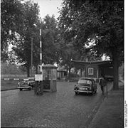
Berlin Wall
The Berlin Wall was a barrier constructed by the German Democratic Republic starting on 13 August 1961, that completely cut off West Berlin from surrounding East Germany and from East Berlin...
. The Checkpoint Heerstraße stretched in its latest stage as far as Weidenweg.
Close to its end, the Heerstraße is joined by the Nennhauser Damm which was in its northern end also the border between the SOZ/GDR with one half being GDR and the other half being West Berlin
West Berlin
West Berlin was a political exclave that existed between 1949 and 1990. It comprised the western regions of Berlin, which were bordered by East Berlin and parts of East Germany. West Berlin consisted of the American, British, and French occupation sectors, which had been established in 1945...
.
This final stretch of the Heerstraße connected together with the Nennhauser Damm to the Staaken Airfield until it was finally closed in the early 1950s. The airfield was briefly mentioned in the movie Battle of Britain
Battle of Britain (film)
Battle of Britain is a 1969 Technicolor film directed by Guy Hamilton, and produced by Harry Saltzman and S. Benjamin Fisz. The film broadly relates the events of the Battle of Britain...
. The airport buildings were later used as hospital. That's where ice skater Katarina Witt
Katarina Witt
Katarina Witt is a German figure skater and model. In Germany she was commonly called "Kati" in the past, but today her full name is used more often....
was born.
Further westbound
The continuing of the Heerstraße as Bundesstraße 5Bundesstraße 5
The Bundesstraße 5 or B5 is a German federal highway running in a northwesterly to southeasterly direction from the Danish border near Niebüll to Frankfurt . It provides a direct route for motorists traveling between Berlin and Hamburg. In Berlin B5 forms among others the following squares and...
in the Federal State of Brandenburg
Brandenburg
Brandenburg is one of the sixteen federal-states of Germany. It lies in the east of the country and is one of the new federal states that were re-created in 1990 upon the reunification of the former West Germany and East Germany. The capital is Potsdam...
is named Hamburger Chaussee. It leads through the Havelland
Havelland
Havelland is a geograhical region and district in Brandenburg, Germany. It is bounded by the districts of Ostprignitz-Ruppin and Oberhavel, the city-state of Berlin, the district of Potsdam-Mittelmark, the city of Brandenburg and the state of Saxony-Anhalt .-History:-Geography:Geographically...
, crosses the Berlin Ring
Bundesautobahn 10
runs in Brandenburg and is an orbital motorway around Berlin and is therefore called the Berliner Ring. It should not be confused with the Berliner Stadtring ....
and runs via Hamburg
Hamburg
-History:The first historic name for the city was, according to Claudius Ptolemy's reports, Treva.But the city takes its modern name, Hamburg, from the first permanent building on the site, a castle whose construction was ordered by the Emperor Charlemagne in AD 808...
right up to the Danish
Denmark
Denmark is a Scandinavian country in Northern Europe. The countries of Denmark and Greenland, as well as the Faroe Islands, constitute the Kingdom of Denmark . It is the southernmost of the Nordic countries, southwest of Sweden and south of Norway, and bordered to the south by Germany. Denmark...
border. In Denmark
Denmark
Denmark is a Scandinavian country in Northern Europe. The countries of Denmark and Greenland, as well as the Faroe Islands, constitute the Kingdom of Denmark . It is the southernmost of the Nordic countries, southwest of Sweden and south of Norway, and bordered to the south by Germany. Denmark...
it continues in Sæd as Primærrute 11 in Tønder Province up to Aalborg
Aalborg
-Transport:On the north side of the Limfjord is Nørresundby, which is connected to Aalborg by a road bridge Limfjordsbroen, an iron railway bridge Jernbanebroen over Limfjorden, as well as a motorway tunnel running under the Limfjord Limfjordstunnelen....
.