
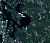
Karikkoselkä
Encyclopedia
Karikkoselkä is a lake
formed in an impact crater
in Petäjävesi
, Finland
. Karikkoselkä is located approximately 30 km east from the centre of Keurusselkä
, a much older and larger impact crater. Most lakes in the region are elongated in northwest-southeast direction due to glaciation, but Karikkoselkä is strikingly round.
Many shatter cone
s, rock formations that form under the extreme pressures of impact, have been found around the lake. Further evidence comes from aeromagnetic maps
, which show a clear magnetic anomaly
in the impact crater area. In addition, samples collected from deep drillings
into the lake bottom confirm the impact origin of the structure.
The crater is the smallest identified in Finland, 1.4 km diameter and 150 m deep. Due to sediment
s the lake has a maximum depth of 26m which is unusually deep for a lake in the region. Karikkoselkä is estimated to be between 230 Ma and 450 Ma (million years old), most likely near 240 Ma (Triassic
or earlier). Some sources give an unreasonably young age of 1.88 Ma, which is likely a misquotation – the discovery paper
mentions that the bedrock
in the region (known as the Central Finland Granite Complex) formed about 1.88 Ga (thousand million years ago), in the late Paleoproterozoic
era.
There is evidence of a neolithic
settlement on the southern shore of the lake. According to a plate erected there no excavations have yet been conducted and the age of the settlement remains unknown.
Lake
A lake is a body of relatively still fresh or salt water of considerable size, localized in a basin, that is surrounded by land. Lakes are inland and not part of the ocean and therefore are distinct from lagoons, and are larger and deeper than ponds. Lakes can be contrasted with rivers or streams,...
formed in an impact crater
Impact crater
In the broadest sense, the term impact crater can be applied to any depression, natural or manmade, resulting from the high velocity impact of a projectile with a larger body...
in Petäjävesi
Petäjävesi
Petäjävesi is a municipality of Finland.It is located in the province of Western Finland, next to Jyväskylä and is part of the Central Finland region. The municipality has a population of and covers an area of of which is water...
, Finland
Finland
Finland , officially the Republic of Finland, is a Nordic country situated in the Fennoscandian region of Northern Europe. It is bordered by Sweden in the west, Norway in the north and Russia in the east, while Estonia lies to its south across the Gulf of Finland.Around 5.4 million people reside...
. Karikkoselkä is located approximately 30 km east from the centre of Keurusselkä
Keurusselkä
Keurusselkä is a lake in Central Finland between the towns of Keuruu to the north and Mänttä to the south. It covers an area of . Its average depth is with a maximum depth of . The surface lies at above sea level. The lake is long and is a part of the Kokemäenjoki water system...
, a much older and larger impact crater. Most lakes in the region are elongated in northwest-southeast direction due to glaciation, but Karikkoselkä is strikingly round.
Many shatter cone
Shatter cone
Shatter cones are rare geological features that are only known to form in the bedrock beneath meteorite impact craters or underground nuclear explosions...
s, rock formations that form under the extreme pressures of impact, have been found around the lake. Further evidence comes from aeromagnetic maps
Aeromagnetic survey
An aeromagnetic survey is a common type of geophysical survey carried out using a magnetometer aboard or towed behind an aircraft. The principle is similar to a magnetic survey carried out with a hand-held magnetometer, but allows much larger areas of the Earth's surface to be covered quickly for...
, which show a clear magnetic anomaly
Magnetic anomaly
In geophysics, a magnetic anomaly is a local variation in the Earth's magnetic field resulting from variations in the chemistry or magnetism of the rocks. Mapping of variation over an area is valuable in detecting structures obscured by overlying material...
in the impact crater area. In addition, samples collected from deep drillings
Boring (earth)
Boring is drilling a hole, tunnel, or well in the earth.-Earth boring:Boring is used for a wide variety of applications in geology, agriculture, hydrology, civil engineering, and oil and natural gas industries...
into the lake bottom confirm the impact origin of the structure.
The crater is the smallest identified in Finland, 1.4 km diameter and 150 m deep. Due to sediment
Sediment
Sediment is naturally occurring material that is broken down by processes of weathering and erosion, and is subsequently transported by the action of fluids such as wind, water, or ice, and/or by the force of gravity acting on the particle itself....
s the lake has a maximum depth of 26m which is unusually deep for a lake in the region. Karikkoselkä is estimated to be between 230 Ma and 450 Ma (million years old), most likely near 240 Ma (Triassic
Triassic
The Triassic is a geologic period and system that extends from about 250 to 200 Mya . As the first period of the Mesozoic Era, the Triassic follows the Permian and is followed by the Jurassic. Both the start and end of the Triassic are marked by major extinction events...
or earlier). Some sources give an unreasonably young age of 1.88 Ma, which is likely a misquotation – the discovery paper
Academic publishing
Academic publishing describes the subfield of publishing which distributes academic research and scholarship. Most academic work is published in journal article, book or thesis form. The part of academic written output that is not formally published but merely printed up or posted is often called...
mentions that the bedrock
Bedrock
In stratigraphy, bedrock is the native consolidated rock underlying the surface of a terrestrial planet, usually the Earth. Above the bedrock is usually an area of broken and weathered unconsolidated rock in the basal subsoil...
in the region (known as the Central Finland Granite Complex) formed about 1.88 Ga (thousand million years ago), in the late Paleoproterozoic
Paleoproterozoic
The Paleoproterozoic is the first of the three sub-divisions of the Proterozoic occurring between . This is when the continents first stabilized...
era.
There is evidence of a neolithic
Neolithic
The Neolithic Age, Era, or Period, or New Stone Age, was a period in the development of human technology, beginning about 9500 BC in some parts of the Middle East, and later in other parts of the world. It is traditionally considered as the last part of the Stone Age...
settlement on the southern shore of the lake. According to a plate erected there no excavations have yet been conducted and the age of the settlement remains unknown.