

List of crossings of the St. Johns River
Encyclopedia
This is a list of bridge
s and other crossings of the Saint Johns River.
|Mayport Ferry
| FL A1A
|
|Mayport
|
|-
|Dames Point Bridge
| FL 9A
FL 9A
 Future Interstate 295
|
|Jacksonville
|
|-
|Mathews Bridge
|
 Alt US 90
 FL 115
(Arlington Expressway)
|
|Jacksonville
|
|-
|Hart Bridge
|
 Alt US 1
|
|Jacksonville
|
|-
|Main Street Bridge
| US 1
US 90
|
|Jacksonville
|
|-
|Acosta Bridge
| FL 13
FL 13
JTA Skyway
|
|Jacksonville
|
|-
|Strauss Trunnion Bridge
|Florida East Coast Railway
|
|Jacksonville
|
|-
|Fuller Warren Bridge
| Interstate 95
|
|Jacksonville
|
|-
|Buckman Bridge
| Interstate 295
|
|Orange Park
|
|-
|Shands Bridge
| FL 16
FL 16
|
|Green Cove Springs
|
|-
|Memorial Bridge
|| US 17
US 17
 FL 100
|_pc5771.jpg)
|Palatka
to East Palatka
|
|-
|Rail bridge
|CSX Transportation
|
|Buffalo Bluff
|29°35′33"N 81°40′51"W
|-
|Fort Gates Ferry
|Fort Gates Ferry Road
|
|Salt Springs
to Welaka
|29°26′0"N 81°39′50"W
|-
|Astor Bridge
| FL 40
FL 40
|
|Astor
to Volusia
|29°10′03"N 81°31′23"W
|-
|Crows Bluff Bridge
| FL 44
FL 44
|
|Crows Bluff to DeLand
|29°00′31"N 81°22′56"W
|-
|Rail bridge
|CSX Transportation
|
|DeBary
to Sanford
|28°50′16"N 81°19′29"W
|-
|Lake Monroe Bridge
|| US 17
 US 92
US 92
|
|DeBary
to Sanford
|28°50′16"N 81°19′27"W
|-
|Veterans Memorial Bridge
| Interstate 4
|
|DeBary
to Sanford
|28°50′09"N 81°19′09"W
|-
|Osteen Bridge
| FL 415
|
|Sanford
to Osteen
|28°48′09"N 81°12′37"W
|-
|Mims Bridge
| FL 46
FL 46
|
|Seminole County
to Volusia County
|28°42′50"N 81°02′00"W
|-
|
| FL 50
FL 50
|
|
|28°32′34"N 80°56′35"W
|-
|Beachline Expressway Bridge
| FL 528
|
|
|
|-
|
| FL 520
|
|
|
|-
|
| US 192
|
|
|
|}
Bridge
A bridge is a structure built to span physical obstacles such as a body of water, valley, or road, for the purpose of providing passage over the obstacle...
s and other crossings of the Saint Johns River.
Florida
|-|Mayport Ferry
Mayport Ferry
The Saint Johns River Ferry, also known as the Mayport Ferry, is an auto ferry between Mayport and Fort George Island, two areas within Jacksonville, Florida. The 0.9 mile voyage crosses the Saint Johns River about 2.5 miles inland of the river's mouth and travels in an east-west direction for...
|
FL A1AFlorida State Road A1A
State Road A1A is a Florida State Road that runs mostly along the Atlantic Ocean, with sections from Key West at the southern tip of Florida, to Callahan, just south of Georgia. It is the main road through most oceanfront towns. SR A1A is designated the A1A Scenic and Historic Coastal Highway, a...
|
|Mayport
|
|-
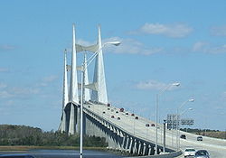
|Dames Point Bridge
Dames Point Bridge
The Dames Point Bridge is a cable-stayed bridge over the St. Johns River in Jacksonville, Florida on State Road 9A. Construction began in 1985 and it was completed in 1989. The main span is 1300 feet, and is 175 feet high...
|
FL 9A Future Interstate 295Interstate 295 (Florida)
Interstate 295 , an auxiliary route of Interstate 95, is a bypass route around central Jacksonville, Florida, which is currently signed on the western half for...
|
|Jacksonville
Jacksonville, Florida
Jacksonville is the largest city in the U.S. state of Florida in terms of both population and land area, and the largest city by area in the contiguous United States. It is the county seat of Duval County, with which the city government consolidated in 1968...
|
|-
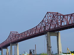
|Mathews Bridge
Mathews Bridge
The Mathews Bridge is a truss bridge in Jacksonville, Florida, which spans the St. Johns River. Constructed in 1953, the bridge brings traffic along the Arlington Expressway between downtown Jacksonville and the Arlington neighborhood. It was named after John E...
|
Alt US 90 FL 115(Arlington Expressway)
|
|Jacksonville
Jacksonville, Florida
Jacksonville is the largest city in the U.S. state of Florida in terms of both population and land area, and the largest city by area in the contiguous United States. It is the county seat of Duval County, with which the city government consolidated in 1968...
|
|-
|Hart Bridge
Hart Bridge
The Isaiah David Hart Bridge is a truss bridge that spans the St. Johns River in Jacksonville, Florida. It is named after Isaiah Hart, the founder of Jacksonville. It was designed by Sverdrup & Parcel.-Details:...
|
Alt US 1|
|Jacksonville
Jacksonville, Florida
Jacksonville is the largest city in the U.S. state of Florida in terms of both population and land area, and the largest city by area in the contiguous United States. It is the county seat of Duval County, with which the city government consolidated in 1968...
|
|-
|Main Street Bridge
Main Street Bridge (Jacksonville)
The Main Street Bridge, officially the John T. Alsop Jr. Bridge, is a bridge crossing the St. Johns River in Jacksonville, Florida. It was the second bridge built across the river. It carries four lanes of traffic, and is signed as U.S. Route 1/US 90 . A lift bridge, it opened in July 1941 at a...
|
US 1U.S. Route 1
U.S. Route 1 is a major north–south U.S. Highway that serves the East Coast of the United States. It runs 2,377 miles from Fort Kent, Maine at the Canadian border south to Key West, Florida. U.S. 1 generally parallels Interstate 95, though it is significantly farther west between...
US 90U.S. Route 90
U.S. Route 90 is an east–west United States highway. Despite the "0" in its route number, U.S. 90 never was a full coast-to-coast route; it has always ended at Van Horn, Texas. A short-lived northward extension to U.S...
|
|Jacksonville
Jacksonville, Florida
Jacksonville is the largest city in the U.S. state of Florida in terms of both population and land area, and the largest city by area in the contiguous United States. It is the county seat of Duval County, with which the city government consolidated in 1968...
|
|-
|Acosta Bridge
Acosta Bridge
The Acosta Bridge spans the St. Johns River in Jacksonville, Florida on a fixed span. It was named for City Councilman St. Elmo W. Acosta, who convinced voters to approve a $950,000 bond issue for the original bridge. It carries SR 13 with the two-track JTA Skyway in the median. Prior to its...
|
FL 13JTA Skyway
|
|Jacksonville
Jacksonville, Florida
Jacksonville is the largest city in the U.S. state of Florida in terms of both population and land area, and the largest city by area in the contiguous United States. It is the county seat of Duval County, with which the city government consolidated in 1968...
|
|-
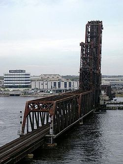
|Strauss Trunnion Bridge
FEC Strauss Trunnion Bascule Bridge
The FEC Strauss Trunnion Bascule Bridge is a double track railroad bridge spanning the St. Johns River in Jacksonville, Florida.Completed in 1925, this structure replaced a single-track swing bridge which opened on January 5, 1890. The current structure is a simple truss bridge with plate girder...
|Florida East Coast Railway
Florida East Coast Railway
The Florida East Coast Railway is a Class II railroad operating in the U.S. state of Florida; in the past, it has been a Class I railroad.Built primarily in the last quarter of the 19th century and the first decade of the 20th century, the FEC was a project of Standard Oil principal Henry Morrison...
|
|Jacksonville
Jacksonville, Florida
Jacksonville is the largest city in the U.S. state of Florida in terms of both population and land area, and the largest city by area in the contiguous United States. It is the county seat of Duval County, with which the city government consolidated in 1968...
|
|-
|Fuller Warren Bridge
|
Interstate 95Interstate 95 in Florida
Interstate 95 is the main Interstate Highway on the east coast of the United States; it serves the Atlantic coast of Florida. It begins at a partial interchange with U.S. Highway 1 just south of downtown Miami, and heads north past Daytona Beach and Jacksonville to the Georgia state line at the St...
|
|Jacksonville
Jacksonville, Florida
Jacksonville is the largest city in the U.S. state of Florida in terms of both population and land area, and the largest city by area in the contiguous United States. It is the county seat of Duval County, with which the city government consolidated in 1968...
|
|-
|Buckman Bridge
|
Interstate 295Interstate 295 (Florida)
Interstate 295 , an auxiliary route of Interstate 95, is a bypass route around central Jacksonville, Florida, which is currently signed on the western half for...
|
|Orange Park
Orange Park, Florida
Orange Park is a town in Clay County, Florida, USA, and a suburb of Jacksonville. The population was 8,412 at the 2010 census. The name "Orange Park" is additionally applied to a wider area of northern Clay County outside the town limits, covering such communities as Fleming Island, Lakeside, and...
|
|-
|Shands Bridge
Shands Bridge
The Shands Bridge is a highway bridge over the St. Johns River near Jacksonville, Florida. The span was first opened in 1929. It was located just north of the current span, crossing from Orangedale to the present Shands pier on the west side of the river....
|
FL 16|
|Green Cove Springs
Green Cove Springs, Florida
Green Cove Springs is a city in Clay County, Florida, United States. The population was 5,378 at the 2000 census. As of 2010, the population recorded by the U.S. Census Bureau is 6,908. It is the county seat of Clay County....
|
|-
|Memorial Bridge
Memorial Bridge (Palatka, Florida)
Memorial Bridge spans the St. Johns River and connects Palatka to East Palatka, Florida. The bridge is the only permanent vehicle crossing between Green Cove Springs and Astor. As such, the bridge is an important part of connecting the region...
||
US 17U.S. Route 17
U.S. Route 17 or U.S. Highway 17 is a north–south United States highway. The highway spans the southeastern United States and is close to the Atlantic Coast for much of its length. The highway's southern terminus is at Punta Gorda, Florida, at an intersection with U.S. Route 41...
FL 100|
|Palatka
Palatka, Florida
Palatka is a city in Putnam County, Florida, United States. The population was 10,033 at the 2000 census. As of 2004, the population recorded by the U.S. Census Bureau is 10,796. It is the county seat of Putnam County and includes East Palatka. Palatka is the principal city of the Palatka...
to East Palatka
East Palatka, Florida
East Palatka is a census-designated place in Putnam County, Florida, United States. The population was 1,654 at the 2010 census.-Geography:East Palatka is located at ....
|
|-
|Rail bridge
|CSX Transportation
CSX Transportation
CSX Transportation operates a Class I railroad in the United States known as the CSX Railroad. It is the main subsidiary of the CSX Corporation. The company is headquartered in Jacksonville, Florida, and owns approximately 21,000 route miles...
|
|Buffalo Bluff
|29°35′33"N 81°40′51"W
|-
|Fort Gates Ferry
|Fort Gates Ferry Road
|
|Salt Springs
Salt Springs, Florida
Salt Springs is an unincorporated community in Marion County, Florida, United States. It is located near Lake George. The community is part of the Ocala Metropolitan Statistical Area....
to Welaka
Welaka, Florida
Welaka is a town situated on the St. Johns River in Putnam County, Florida. The population was 586 as of the 2000 census. According to the U.S. Census Bureau's 2004 estimates, the town had a population of 604...
|29°26′0"N 81°39′50"W
|-
|Astor Bridge
|
FL 40|
|Astor
Astor, Florida
Astor is a census-designated place in Lake County, Florida, United States. It is located along the St. Johns River between Lake George and Lake Dexter, across from the community of Volusia. The population was 1,487 at the 2000 census...
to Volusia
Volusia, Florida
Volusia is an unincorporated community in Volusia County, Florida on the eastern shore of the St. Johns River, about three miles south of Lake George and across the river from the town of Astor in Lake County...
|29°10′03"N 81°31′23"W
|-
|Crows Bluff Bridge
|
FL 44|
|Crows Bluff to DeLand
DeLand, Florida
DeLand is the county seat of Volusia County, Florida. In 2006, the U.S. Census Bureau estimated the city's population to be 24,375. It is part of the Deltona-Daytona Beach-Ormond Beach, Florida Metropolitan Statistical Area, which had an estimated population of 436,575 in 2006...
|29°00′31"N 81°22′56"W
|-
|Rail bridge
|CSX Transportation
CSX Transportation
CSX Transportation operates a Class I railroad in the United States known as the CSX Railroad. It is the main subsidiary of the CSX Corporation. The company is headquartered in Jacksonville, Florida, and owns approximately 21,000 route miles...
|
|DeBary
DeBary, Florida
As of the census of 2000, there were 15,559 people, 6,538 households, and 4,720 families residing in the city. The population density was 853.8 inhabitants per square mile . There were 7,001 housing units at an average density of 384.2 per square mile...
to Sanford
Sanford, Florida
Sanford is a city in, and the county seat of, Seminole County, Florida, United States. The population was 38,291 at the 2000 census. As of 2009, the population recorded by the U.S. Census Bureau was 50,998...
|28°50′16"N 81°19′29"W
|-
|Lake Monroe Bridge
||
US 17U.S. Route 17
U.S. Route 17 or U.S. Highway 17 is a north–south United States highway. The highway spans the southeastern United States and is close to the Atlantic Coast for much of its length. The highway's southern terminus is at Punta Gorda, Florida, at an intersection with U.S. Route 41...
US 92U.S. Route 92
U.S. Route 92 is a 177 mile intrastate U.S. Route in the U.S. state of Florida. The western terminus is at Alt US 19, SR 595, and SR 687 in downtown St. Petersburg. The eastern terminus is at SR A1A in Daytona Beach. Most of US 92 is designated unsigned State Road 600.-Route description:US 92...
|
|DeBary
DeBary, Florida
As of the census of 2000, there were 15,559 people, 6,538 households, and 4,720 families residing in the city. The population density was 853.8 inhabitants per square mile . There were 7,001 housing units at an average density of 384.2 per square mile...
to Sanford
Sanford, Florida
Sanford is a city in, and the county seat of, Seminole County, Florida, United States. The population was 38,291 at the 2000 census. As of 2009, the population recorded by the U.S. Census Bureau was 50,998...
|28°50′16"N 81°19′27"W
|-
|Veterans Memorial Bridge
St. Johns River Veterans Memorial Bridge
The original St. Johns River Bridge was a four-lane concrete-and-steel causeway bridge constructed over the St. Johns River at the west outlet of Lake Monroe. It is a part of Interstate 4, and spans the border between Seminole and Volusia Counties in Florida, United States...
|
Interstate 4Interstate 4
Interstate 4 is a intrastate Highway located entirely within the state of Florida, United States. It goes from Interstate 275 in Tampa, Florida to Interstate 95 at Daytona Beach, Florida . It also has the Florida Department of Transportation designation of State Road 400, but only a small...
|
|DeBary
DeBary, Florida
As of the census of 2000, there were 15,559 people, 6,538 households, and 4,720 families residing in the city. The population density was 853.8 inhabitants per square mile . There were 7,001 housing units at an average density of 384.2 per square mile...
to Sanford
Sanford, Florida
Sanford is a city in, and the county seat of, Seminole County, Florida, United States. The population was 38,291 at the 2000 census. As of 2009, the population recorded by the U.S. Census Bureau was 50,998...
|28°50′09"N 81°19′09"W
|-
|Osteen Bridge
|
FL 415|
|Sanford
Sanford, Florida
Sanford is a city in, and the county seat of, Seminole County, Florida, United States. The population was 38,291 at the 2000 census. As of 2009, the population recorded by the U.S. Census Bureau was 50,998...
to Osteen
Osteen, Florida
Osteen, Florida is an unincorporated community located in southwest Volusia County. The , a 150-acre nature preserve with hiking and horse trails is located in Osteen.-History:...
|28°48′09"N 81°12′37"W
|-
|Mims Bridge
|
FL 46|
|Seminole County
Seminole County, Florida
Seminole County is a county in the U.S. state of Florida. Located between Orlando to the south and Deland and Daytona Beach to the north, it is part of the Greater Orlando metropolitan area. Its county seat and largest city is Sanford...
to Volusia County
Volusia County, Florida
Volusia County is a county located in the state of Florida. The U.S. Census Bureau 2010 official county's population was 494,593 . Its county seat is DeLand, and its most populous city is currently Deltona....
|28°42′50"N 81°02′00"W
|-
|
|
FL 50|
|
|28°32′34"N 80°56′35"W
|-
|Beachline Expressway Bridge
|
FL 528|
|
|
|-
|
|
FL 520|
|
|
|-
|
|
US 192U.S. Route 192
U.S. Route 192 is an east–west route of the United States Numbered Highway system in central Florida. It runs 75.04 miles from U.S. Route 27 in Citrus Ridge, Lake County, east past Walt Disney World and through Kissimmee, St. Cloud and Melbourne, to end at State Road A1A in Indialantic, one...
|
|
|
|}
See also
- List of crossings of the Aucilla River
- List of crossings of the Halifax River
- List of crossings of the Ochlockonee River
- List of crossings of the Suwannee River