

Mogán, Las Palmas
Encyclopedia
| Municipality of Mogán | |
| Map | |
|---|---|
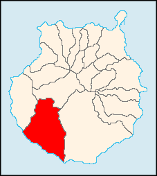 |
|
| Statistics | |
| Autonomous region: | Canary Islands Canary Islands The Canary Islands , also known as the Canaries , is a Spanish archipelago located just off the northwest coast of mainland Africa, 100 km west of the border between Morocco and the Western Sahara. The Canaries are a Spanish autonomous community and an outermost region of the European Union... |
| Province: | Las Palmas Las Palmas (province) The Province of Las Palmas is a province of Spain, consisting of the eastern part of the autonomous community of the Canary Islands.-Composition:... |
| Island: | Gran Canaria Gran Canaria Gran Canaria is the second most populous island of the Canary Islands, with a population of 838,397 which constitutes approximately 40% of the population of the archipelago... |
| Area Area Area is a quantity that expresses the extent of a two-dimensional surface or shape in the plane. Area can be understood as the amount of material with a given thickness that would be necessary to fashion a model of the shape, or the amount of paint necessary to cover the surface with a single coat... : |
172 km² |
| Population Population A population is all the organisms that both belong to the same group or species and live in the same geographical area. The area that is used to define a sexual population is such that inter-breeding is possible between any pair within the area and more probable than cross-breeding with individuals... : |
15,176 (2004) |
| Population density Population density Population density is a measurement of population per unit area or unit volume. It is frequently applied to living organisms, and particularly to humans... : |
88.17/km² |
| Elevation Elevation The elevation of a geographic location is its height above a fixed reference point, most commonly a reference geoid, a mathematical model of the Earth's sea level as an equipotential gravitational surface .... : Lowest: Centre: Highest: |
Atlantic Ocean Atlantic Ocean The Atlantic Ocean is the second-largest of the world's oceanic divisions. With a total area of about , it covers approximately 20% of the Earth's surface and about 26% of its water surface area... 252 m northeastern part |
| Location Geographic coordinate system A geographic coordinate system is a coordinate system that enables every location on the Earth to be specified by a set of numbers. The coordinates are often chosen such that one of the numbers represent vertical position, and two or three of the numbers represent horizontal position... : |
27.8667/27°53' N lat. 15.6883/15°43' W long. |
| Municipal code: | E-35012 |
| Car designation: | GC until 2001 |
Gran Canaria
Gran Canaria is the second most populous island of the Canary Islands, with a population of 838,397 which constitutes approximately 40% of the population of the archipelago...
, which is one of the three main islands making up the Spanish province of Las Palmas
Las Palmas (province)
The Province of Las Palmas is a province of Spain, consisting of the eastern part of the autonomous community of the Canary Islands.-Composition:...
in the Canary Islands
Canary Islands
The Canary Islands , also known as the Canaries , is a Spanish archipelago located just off the northwest coast of mainland Africa, 100 km west of the border between Morocco and the Western Sahara. The Canaries are a Spanish autonomous community and an outermost region of the European Union...
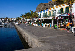
. It includes the fishing towns of Puerto de Mogán
Puerto de Mogán
Puerto de Mogán is a picturesque resort and fishing village in the municipality of Mogán, set at the mouth of a steep-sided valley on the southwest coast of the island of Gran Canaria and attracts many tourists either to stay or on day-visits. Canal-like channels linking the marina to the fishing...
and Arguineguin
Arguineguin
Arguineguín , also Arguinegín is one of the most populated towns along the south coast of Gran Canaria, Spain. A typical Canarian fishing village, it is home to many locals rather than being a tourist resort...
. Mogán is the second largest municipality by area on the island. The population is 15,176 (ISTAC, 2003), its density is 88.17/km² and the area is 172 km². Much of the population lives on the Atlantic coastline. The terrain consists of mountains and a valley area that are mostly covered with vegetation and forests. Barren land dominates the northern, central and eastern parts, especially in the mountain areas, while farmlands and urban areas lie within 2 to 3 km of the Atlantic Ocean and in the narrow steep sided barrancos, or valleys.
The town of Mogán is about 12 kilometres from the coast and north-west of Puerto Rico and is accessed by following the coast road after leaving the GC-1 motorway by its southernmost exit, (58th km interchange or exit 58/59). The main industries are tourism, agriculture and fishing. The tourism industry is located mainly along the coast, which has a string of resorts. Mogàn is part of a larger tourist area in the southern part of the island.
Geography
- Location:
- Latitude: 27.8667 (27°52') N
- Longitude: 15.7883 (15°43') W
- Altitude:
- Lowest: Atlantic Ocean
- Centre: 252 m
- Highest: northern part
- Postal code: - 351 38
Historical population
| Year | Population | Density |
|---|---|---|
| 1991 | 8,688 | - |
| 1996 | 10,398 | - |
| 2001 | 12,444 | 72.34/km² |
| 2002 | 15,935 | - |
| 2003 | 15,932 | 98.06/km² |
| 2004 | 15,176 | 88.17/km² |
Communities
- ArguineguinArguineguinArguineguín , also Arguinegín is one of the most populated towns along the south coast of Gran Canaria, Spain. A typical Canarian fishing village, it is home to many locals rather than being a tourist resort...
- Playa de Mogán (Mogán Beach)
- Puerto de MogánPuerto de MogánPuerto de Mogán is a picturesque resort and fishing village in the municipality of Mogán, set at the mouth of a steep-sided valley on the southwest coast of the island of Gran Canaria and attracts many tourists either to stay or on day-visits. Canal-like channels linking the marina to the fishing...
- Playa de Diablillo
- Puerto Rico de Gran CanariaPuerto Rico de Gran CanariaPuerto Rico is a specially constructed holiday resort situated on the south-west coast of Gran Canaria. The island's proximity to the African continent ensures an ideal climate, particularly in the winter, when the temperatures remain constant at around 20-25°C.The volcanic origins of Gran Canaria...
Mogan has schools, lyceums, a few gymnasia, churches, a post office and squares (plaza).
See also
| Northwest: San Nicolás de Tolentino La Aldea de San Nicolás La Aldea de San Nicolás or San Nicolás de Tolentino is a Canarian municipality in the western portion of the island of Gran Canaria in the Las Palmas province in the Canary Islands and is the westernmost municipality in the province... or La Aldea de San Nicolás |
North: Tejeda | |
| West: San Nicolás de Tolentino or La Aldea de San Nicolás | Mogán | East: San Bartolomé de Tirajana San Bartolomé de Tirajana San Bartolomé de Tirajana is a Canarian municipality in the southeastern portion of the island of Gran Canaria in the Las Palmas province in the Canary Islands... |
| South: Atlantic Ocean Atlantic Ocean The Atlantic Ocean is the second-largest of the world's oceanic divisions. With a total area of about , it covers approximately 20% of the Earth's surface and about 26% of its water surface area... |
External links
- Mogán tourism
- Map and aerial photos
- Street map: Street map from Mapquest, MapPoint, Google or Yahoo! Maps
- Satellite images: Google or Microsoft Virtual Earth - image now available
- Coordinates: 27°52′0"N 15°43′0"W