

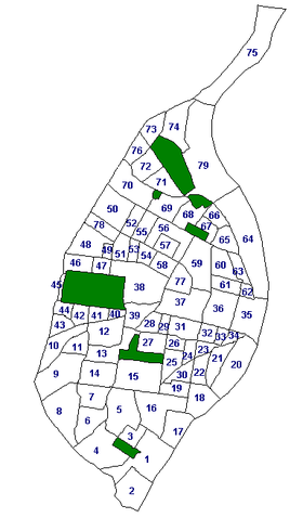
Neighborhoods of St. Louis
Encyclopedia
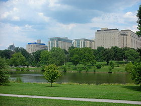
St. Louis, Missouri
St. Louis is an independent city on the eastern border of Missouri, United States. With a population of 319,294, it was the 58th-largest U.S. city at the 2010 U.S. Census. The Greater St...
, is divided into 79 neighborhoods. Census
Census
A census is the procedure of systematically acquiring and recording information about the members of a given population. It is a regularly occurring and official count of a particular population. The term is used mostly in connection with national population and housing censuses; other common...
data is collected for each neighborhood, as well as crime data
Crime statistics
Crime statistics attempt to provide statistical measures of the crime in societies. Given that crime is usually secretive by nature, measurements of it are likely to be inaccurate....
, historic property data, and dining establishment health ratings
Restaurant rating
Restaurant ratings identify restaurants according to their quality, using various notations such as stars or other symbols, or numbers. Stars are a familiar and popular symbol, with ratings of one to four or five stars commonly used. Ratings appear in guidebooks as well as in the media, typically...
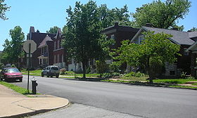
. National historic neighborhoods
Historic preservation
Historic preservation is an endeavor that seeks to preserve, conserve and protect buildings, objects, landscapes or other artifacts of historical significance...
are identified by the official neighborhood to which they belong.
Also, several neighborhood names extend to areas well beyond their technical borders. For example, Downtown St. Louis
Downtown St. Louis
Downtown St. Louis is the central business district of St. Louis, Missouri, the hub of tourism and entertainment, and the anchor of the St. Louis metropolitan area. The downtown is bounded by Cole Street to the north, the river front to the east, Chouteau Avenue to the south, and Jefferson Avenue...
is generally thought to include the St. Louis Union Station and the Scottrade Center
Scottrade Center
Scottrade Center is a 19,150 seat arena located in downtown St. Louis, Missouri, opened in 1994. It is the home of the St...
, even though Downtown technically ends at Tucker Avenue (12th Street). Additionally, the Fox Theatre and Powell Symphony Hall
Powell Symphony Hall
Powell Symphony Hall is the home of the Saint Louis Symphony Orchestra. It was named after Walter S. Powell, a local St. Louis businessman, whose widow donated $1 million towards the purchase and use of this hall by the symphony...
are popularly considered a part of Midtown St. Louis
Midtown St. Louis
Midtown St. Louis is three miles west of the St. Louis, Missouri riverfront at the crossroads of Grand Boulevard and Lindell Boulevard. It includes the campus of Saint Louis University and the Grand Center arts district.-Historic status:...
even though they are in Grand Center. Dogtown
Dogtown, St. Louis
-Location:Dogtown is a traditionally Irish section of St. Louis, Missouri, best known for its annual . It is located south of Forest Park, with its southeastern edge abutting the traditionally Italian section of town, The Hill neighborhood. The boundaries of Dogtown are Oakland Avenue on the north,...
is an area south of Forest Park that includes at least 4 distinct neighborhoods. Moreover, sometimes several neighborhoods are lumped together in categories such as "North City" and "South City." These last distinctions - between north and south - carry racial distinctions because the City of St. Louis used to be racially segregated
Racial segregation in the United States
Racial segregation in the United States, as a general term, included the racial segregation or hypersegregation of facilities, services, and opportunities such as housing, medical care, education, employment, and transportation along racial lines...
by legally enforceable racially restrictive covenants (i.e., restrictions in property deeds that forbade sales to persons of particular races), and effectively still is segregated by circumstance; North City was the "black" half while South City was the "white" half (see also Crime in St. Louis, Missouri). This has changed somewhat as many blacks have settled in South City, but the central corridor, in between remains the most racially integrated area. However, North City used to have large Polish
Polish American
A Polish American , is a citizen of the United States of Polish descent. There are an estimated 10 million Polish Americans, representing about 3.2% of the population of the United States...
and German
German American
German Americans are citizens of the United States of German ancestry and comprise about 51 million people, or 17% of the U.S. population, the country's largest self-reported ancestral group...
- among others - immigrant populations, evidenced by the churches they built, such as St. Stanislaus Kostka Church.
List of neighborhoods
St. Louis, Missouri
St. Louis is an independent city on the eastern border of Missouri, United States. With a population of 319,294, it was the 58th-largest U.S. city at the 2010 U.S. Census. The Greater St...
.
| 01 | Carondelet Carondelet, St. Louis Carondelet is a neighborhood in the extreme southeastern portion of St. Louis, Missouri. It was incorporated as an independent city in 1851 and was annexed by the City of St. Louis in 1870. As of the 2000 Census, the neighborhood has a population of 9,960 people.Originally, the neighborhood was... |
21 | Soulard Soulard, St. Louis Soulard is a historic French neighborhood in St. Louis, Missouri. It is named after Antoine Soulard, who first began to develop the land... |
41 | Cheltenham Cheltenham, St. Louis Cheltenham is a neighborhood of St. Louis, Missouri, within a section known as Dogtown. It is bound by Forest Park on the north, Macklind on the east, Manchester Avenue on the south, and Hampton Avenue on the west. Businesses located in Cheltenham include the St. Louis Community College at Forest... |
61 | Carr Square Carr Square, St. Louis Carr Square is a neighborhood of St. Louis, Missouri. The near Northside neighborhood is bounded by Cass Avenue on the North, Cole Street on the South, North Tucker Boulevard and North 13th Street on the East, and North Jefferson on the West. It was the site, from 1954 to 1971, of the infamous... |
| 02 | Patch Patch, St. Louis Patch is a neighborhood of St. Louis, Missouri. The Patch neighborhood forms the southern tip of the Carondelet neighborhood. It is defined by Robert on the north, the City Limits to the south, Alabama to the west, and by the Mississippi river to the east.... |
22 | Benton Park Benton Park, St. Louis Benton Park is a neighborhood in eastern St. Louis, Missouri, just west of the Soulard neighborhood. The official boundaries of the area are Gravois Avenue on the north, Cherokee Street on the south, I-55 on the east, and Jefferson Avenue on the west... |
42 | Clayton/Tamm Clayton/Tamm, St. Louis Clayton-Tamm is a traditionally Irish-American neighborhood located near the western border of St. Louis, Missouri, USA, just south of Forest Park.... |
62 | Columbus Square Columbus Square, St. Louis Columbus Square is a neighborhood of St. Louis, Missouri. It is bounded by Cass Avenue to the north, I-70 to the east, Tucker & North 13th Streets to the west, and Cole Street to the south.... |
| 03 | Holly Hills Holly Hills, St. Louis Holly Hills is a neighborhood located in South St. Louis, Missouri, near the intersection of I-55 and Loughborough Avenue. The neighborhood is defined by Bates and Walsh on the Northeast, Holly Hills on the Southwest, Leona and the Missouri Pacific Railroad on the Northwest and Grand Boulevard on... |
23 | McKinley Heights McKinley Heights, St. Louis The McKinley Heights Neighborhood is an historic conservation district located in the near South Side of the City of St. Louis. The neighborhood is bounded by I-44 to the north, Jefferson Avenue to the west, and I-55 and Gravois Boulevard to the east and south. There are restaurants and... |
43 | Franz Park Franz Park, St. Louis Franz Park is a neighborhood of St. Louis, Missouri.-See also:* Clayton/Tamm, St. Louis in the east* Ellendale, St. Louis neighborhood directly to the south* Hi-Pointe, St. Louis in the north... |
63 | Old North St. Louis Old North St. Louis Old North St. Louis is a neighborhood just north and very slightly west of the downtown area of St. Louis, Missouri. Known for the landmark Crown Candy Kitchen, historic 19th century brick homes, and its award-winning community gardens, Old North St. Louis is home to a diverse and active community.... |
| 04 | Boulevard Heights Boulevard Heights, St. Louis Boulevard Heights is a neighborhood of St. Louis, Missouri.- References :... |
24 | Fox Park Fox Park, St. Louis Fox Park is a neighborhood of St. Louis, Missouri. The neighborhood borders are Jefferson Avenue to the east, Interstate 44 to the north, Gravois Avenue to the south and Nebraska Avenue to the west. Surrounding neighborhoods include the Gate District, Compton Heights, Tower Grove East, Benton Park... |
44 | Hi-Pointe Hi-Pointe, St. Louis Hi-Pointe is a neighborhood of St. Louis, Missouri, within a section known as Dogtown. It is bounded by Clayton Avenue and Oakland Avenue on the north, City Limits on the west, Dale Avenue on the south, and Louisville Avenue on the east... |
64 | Near North Riverfront Near North Riverfront, St. Louis Near North Riverfront is a neighborhood of St. Louis, Missouri. Between 1990 and 2000 Near North Riverfront led the city in percentage population growth, growing 89% over the decade. Despite this large percentage growth, Near North Riverfront is largely non-residential and so the 89% pecentage gain... |
| 05 | Bevo Mill Bevo Mill, St. Louis Bevo Mill is a neighborhood located in south St. Louis, Missouri.-Namesake and location:The neighborhood's name comes from the "Bevo Mill building", a local landmark that was designed in the style of Dutch and German windmills for grinding grain. The Mill building was built in 1916 to serve as a... |
25 | Tower Grove East Tower Grove East, St. Louis Tower Grove East is a neighborhood of St. Louis, Missouri. The neighborhood is a part of the Tower Grove area. The Tower Grove East neighborhood is bordered by Shenandoah Avenue to the north, Nebraska Avenue to the east, Gravois Avenue to the south, and south Grand Boulevard to the west.The... |
45 | Wydown/Skinker Wydown/Skinker, St. Louis Wydown/Skinker is a neighborhood in St. Louis, Missouri. Washington University in St. Louis is located just north of this neighborhood. The neighborhood is bounded by the city limits on the west, Forsyth Boulevard on the north, Forest Park on the east, and Clayton Road on the south... |
65 | Hyde Park Hyde Park, St. Louis Hyde Park is a neighborhood of St. Louis, Missouri. A historic North St. Louis neighborhood, Hyde Park is bound by Ferry to the North, I-70 to the East, Palm Street and Natural Bridge Avenue to the South, and Glasgow to the West.... |
| 06 | Princeton Heights Princeton Heights, St. Louis Princeton Heights is an older South St. Louis residential neighborhood. Princeton Heights has many features of a homey small town, but it happens to be in a big city, the City of St Louis Missouri... |
26 | Compton Heights Compton Heights, St. Louis The Compton Heights historic neighborhood located on the near Southside of the City of St. Louis, Missouri in the shadow of the great water tower of Reservoir Park is one of the earliest planned residential developments of the American nineteenth century... |
46 | Skinker/DeBaliviere Skinker/DeBaliviere, St. Louis Skinker DeBaliviere is a neighborhood of St. Louis, Missouri located directly north of Forest Park. In addition to the park, its boundaries are Delmar Boulevard to the north, DeBaliviere Avenue to the east, and the western city limits... |
66 | College Hill College Hill, St. Louis College Hill is a neighborhood of St. Louis, Missouri. The name College Hill was given to this area because it was the location of the St. Louis University College Farm. This area, bounded generally by Warne College Hill is a neighborhood of St. Louis, Missouri. The name College Hill was given to... |
| 07 | Southampton Southampton, St. Louis Southampton is a neighborhood in St. Louis, Missouri. Located in the southern reaches of the city, its borders are Chippewa Street on the north, Hampton Avenue on the west, Eichelberger Street on the south and South Kingshighway Boulevard on the east. It is a quiet neighborhood that was... |
27 | Shaw Shaw, St. Louis Shaw is a neighborhood in St. Louis, Missouri. It is bordered on the North by Interstate 44, the east by S. Grand Blvd., the west by Tower Grove Ave and the Missouri Botanical Gardens, and the south by Tower Grove Park.-History:... |
47 | DeBaliviere Place DeBaliviere Place, St. Louis DeBaliviere ' Place is a neighborhood of St. Louis, Missouri.-Location:The DeBaliviere Place neighborhood is bounded by Delmar Boulevard on the North, Union Boulevard on the East, Lindell Boulevard on the South, and Debaliviere Avenue on the west.-Characteristics:The DeBaliviere Place neighborhood... |
67 | Fairground Fairground Neighborhood, St. Louis Fairground is a neighborhood of St. Louis, Missouri. The neighborhood’s boundaries are defined as Glasgow Avenue on the east, west and North Florissant Avenues on the north, Warne on the west, and Fairground Park and Natural Bridge Avenue on the south.... |
| 08 | St. Louis Hills St. Louis Hills St. Louis Hills is a neighborhood in St. Louis, Missouri. The neighborhood, which is home to the Chippewa location of Ted Drewes Frozen Custard, is situated in the southwest of St. Louis. It is bounded by Chippewa Street to the northwest and north, Hampton Avenue to the east, Gravois Avenue to... |
28 | Botanical Heights Botanical Heights, St. Louis Botanical Heights is a neighborhood of St. Louis, Missouri. Its former name was McRee Town. The Botanical Heights neighborhood is defined by Chouteau Avenue on the North, Interstate 44 on the South, 39th Street on the East and Vandeventer Avenue on the West. This near Southside neighborhood is... |
48 | West End West End, St. Louis West End is a neighborhood of St. Louis, Missouri. This neighborhood is defined by Page Boulevard on the North, Delmar Boulevard on the South, Belt Avenue and Union Boulevard via Maple Avenue on the East, and City limits on the West. The neighborhood is home to the Emmanuel DeHodiamont House, one... |
68 | O'Fallon O'Fallon, St. Louis O'Fallon is a neighborhood of St. Louis, Missouri. The neighborhood is located on the north side of the City of St. Louis, nestled between O’Fallon Park and Fairgrounds Park... |
| 09 | Lindenwood Park Lindenwood Park, St. Louis Lindenwood Park is a neighborhood of St. Louis, Missouri. The Lindenwood Neighborhood is defined by Arsenal Street and I-44 to the north, Watson and Chippewa Street to the south, Hampton Avenue on the east and the city limits to the west... |
29 | Tiffany Tiffany, St. Louis Tiffany is a neighborhood of St. Louis, Missouri. The neighborhood is located on the western side of Grand Boulevard along the section containing St. Louis University’s Medical Complex... |
49 | Visitation Park Visitation Park, St. Louis Visitation Park is a neighborhood of St. Louis, Missouri. The neighborhood is defined by Maple Avenue on the North, Delmar Boulevard on the South, Union Boulevard on the East, and Belt Avenue on the West. Visitation Park is a small neighborhood nestled southeast of the West End neighborhood, just... |
69 | Penrose Penrose, St. Louis Penrose is a neighborhood of St. Louis, Missouri. The neighborhood is located on the north side of the city just south of Interstate 70 and west of O’Fallon Park. It is bounded by Florissant Avenue and I-70 on the north, Natural Bridge on the south, North Newstead and Pope Avenue on the east, and... |
| 10 | Ellendale Ellendale, St. Louis Ellendale is a neighborhood of St. Louis, Missouri. Its eastern portion is considered a part of Dogtown, which also includes four other neighborhoods north of Manchester.-Location:... |
30 | Benton Park West Benton Park West, St. Louis Benton Park West is a neighborhood located in South St. Louis City, Missouri, USA. The neighborhood is bounded by Jefferson Ave. on the east, Gravois Ave. on the north and west, and an irregular boundary consisting of Cherokee Street, S. Compton Ave., and Potomac Street to the south... |
50 | Wells/Goodfellow Wells/Goodfellow, St. Louis Wells/Goodfellow is a neighborhood of St. Louis, Missouri. The borders of the neighborhood are defined by the St. Louis city limits on the north-western edge, Dr... |
70 | Mark Twain/I-70 Industrial Mark Twain/I-70 Industrial, St. Louis Mark Twain/I-70 Industrial is a neighborhood of St. Louis, Missouri. It is bound by I-70 to the north, North Kingshighway to the east, Natural Bridge Road to the south, and the city limit to the west.-References:... |
| 11 | Clifton Heights Clifton Heights, St. Louis Clifton Heights is a neighborhood of St. Louis, Missouri, located along the southwest border of the city and highlighted by a park—Clifton Park —with a playground and a lake.... |
31 | Gate District Gate District, St. Louis The Gate District is a neighborhood of St. Louis, Missouri. The Gate District is defined as the area between Chouteau Avenue and Interstate 44 on the north and south and between South Jefferson Avenue and South Grand Boulevard on the east and west... |
51 | Academy Academy, St. Louis Academy/Sherman Park is a neighborhood in North St. Louis, just outside Central West End. The official boundaries of the area are Dr. Martin Luther King Drive on the north, Delmar Boulevard on the south, North Kingshighway Boulevard on the east, and Union Boulevard on the west.As of the census of... |
71 | Mark Twain Mark Twain, St. Louis Mark Twain is a neighborhood of St. Louis, Missouri. It is located between Interstate 70 and Calvary Cemetery.-References:... |
| 12 | The Hill The Hill, St. Louis The Hill is a mostly Italian-American neighborhood within St. Louis, Missouri, located on high ground south of Forest Park. The official boundaries of the area are Manchester Avenue on the north, Columbia and Southwest Avenues on the south, South Kingshighway Boulevard on the east, and Hampton... |
32 | Lafayette Square Lafayette Square, St. Louis Lafayette Square is a neighborhood in St. Louis, Missouri that is bounded on the north by Chouteau Avenue, on the south by Interstate 44, on the east by Truman Parkway and on the west by South Jefferson Avenue. It surrounds Lafayette Park, which is the city's oldest public park, created by... |
52 | Kingsway West Kingsway West, St. Louis Kingsway West is a neighborhood of St. Louis, Missouri. The Kingsway West neighborhood is defined by Union Boulevard to its north-west and Dr. Martin Luther King Drive to its south-west... |
72 | Walnut Park East Walnut Park East, St. Louis Walnut Park East is a neighborhood of St. Louis, Missouri. Walnut Park East is one of several neighborhoods in northwest St. Louis. Its borders are West Florissant Avenue to the northeast, Emerson Avenue to the southeast, Interstate 70 to the southwest and west, and Riverview Boulevard to the... |
| 13 | Southwest Garden Southwest Garden, St. Louis Southwest Garden is a neighborhood of St. Louis, Missouri.-About:The Southwest Garden District is a Horse head shaped neighborhood between The Hill and Tower Grove Park. It is bordered by Southwest, I-44 and Columbia Ave... |
33 | Peabody/Darst/Webbe Peabody/Darst/Webbe, St. Louis Peabody–Darst–Webbe is a neighborhood of St. Louis, Missouri. It is also called the Near Southside neighborhood. Peabody–Darst–Webbe is an area bounded by S. Tucker Blvd. on the east, Chouteau Ave. on the north, Dolman Street on the west, and the I-55/I-44 interchange on... |
53 | Fountain Park Fountain Park, St. Louis Fountain Park is a neighborhood of St. Louis, Missouri. The Fountain Park neighborhood is located in north St. Louis, Missouri with Martin Luther King on the north, Delmar on the south, Walton on the east, and Kingshighway on the west. It is just two blocks north of the Central West End of the... |
73 | North Point North Point, St. Louis North Point is a middle class primarily African American neighborhood of St. Louis, Missouri, USA. It is bounded by Goodfellow on the North, Northcrest, West Florissant on the Southwest, and Riverview Boulevard on the East and Northeast.... |
| 14 | North Hampton North Hampton, St. Louis North Hampton is a neighborhood of St. Louis, Missouri. Located in Southwest City, Northampton is bounded by Scanlan and Connecticut to the north, South Kingshighway Boulevard to the east, Chippewa Street to the south, and Hampton Avenue to the west.... |
34 | LaSalle Park | 54 | Lewis Place Lewis Place, St. Louis Lewis Place is a neighborhood of St. Louis, Missouri. Lewis Place is defined by Martin Luther King Drive on the North, Delmar Boulevard on the South, Newstead Avenue on the East, and Walton on the West.-History:... |
74 | Baden Baden, St. Louis Baden became a part of the City of St. Louis in 1876 by the State legislature. Baden population was made up of 400 people. The neighborhood was located on the Kansas City and Northwestern Railroad... |
| 15 | Tower Grove South Tower Grove South, St. Louis Tower Grove South is a neighborhood of St. Louis, Missouri. Formerly known as Oak Hill, Tower Grove South is bounded by Arsenal Street on the north, Chippewa Street on the south, Kingshighway Boulevard on the west, and Grand Boulevard on the east. The majority of the neighborhood was built... |
35 | Downtown Downtown St. Louis Downtown St. Louis is the central business district of St. Louis, Missouri, the hub of tourism and entertainment, and the anchor of the St. Louis metropolitan area. The downtown is bounded by Cole Street to the north, the river front to the east, Chouteau Avenue to the south, and Jefferson Avenue... |
55 | Kingsway East Kingsway East, St. Louis Kingsway East is a neighborhood of St. Louis, Missouri. The neighborhood is generally defined by Natural Bridge on the North, Martin Luther King on the South, Marcus Avenue on the East, and Kingshighway on the West.-Institutions:... |
75 | Riverview Riverview, St. Louis Riverview is a neighborhood of St. Louis, Missouri. Riverview comprises the extreme northern section of the city, bounded by the Mississippi River to the east, the city limits to the west, and Chain of Rocks Road to the south, with the northern boundary lying a third of a mile north of I-270. The... |
| 16 | Dutchtown Dutchtown, St. Louis Dutchtown is a neighborhood of St. Louis, Missouri. It is called "Dutch" from Deutsch, i.e., "German", as it was the southern center of German-American settlement in St. Louis in the early 19th century... |
36 | Downtown West Downtown West, St. Louis Downtown West is a neighborhood of St. Louis, Missouri. It is, as the name suggests, a section of downtown that is further inland, west from the banks of the Mississippi river. St. Louis City Hall, the Peabody Opera House, the Scottrade Center arena, and St. Louis Union Station are all located in... |
56 | Greater Ville Greater Ville, St. Louis Greater Ville is a neighborhood of St. Louis, Missouri. The area is bounded by Marcus Avenue on the northwest, Natural Bridge Road on the northeast, Dr. Martin Luther King Drive and St. Louis Avenue on the south via North Taylor Avenue and Sarah Street, and North Vandeventer Avenue on the... |
76 | Walnut Park West Walnut Park West, St. Louis Walnut Park West is a neighborhood of St. Louis, Missouri. The Walnut Park West neighborhood is situated in northwest St. Louis. It is bounded by West Florissant Avenue to the northeast, Riverview Boulevard to the southeast, Interstate Highway 70 to the south, and the City limits to the west and... |
| 17 | Mount Pleasant Mount Pleasant, St. Louis Mount Pleasant is a neighborhood of St. Louis, Missouri. The neighborhood's boundaries are defined by Virginia Avenue on the west, the Mississippi River on the east, Meramec Street on the north, and Delor Street on the south.-References:... |
37 | Midtown Midtown St. Louis Midtown St. Louis is three miles west of the St. Louis, Missouri riverfront at the crossroads of Grand Boulevard and Lindell Boulevard. It includes the campus of Saint Louis University and the Grand Center arts district.-Historic status:... |
57 | The Ville The Ville, St. Louis The Ville is a historic neighborhood located in North St. Louis, Missouri.This neighborhood is bounded by St. Louis Avenue on the North, Martin Luther King drive on the South, Sarah on the East and Taylor on the West.... |
77 | Covenant Blu Grand Center |
| 18 | Marine Villa Marine Villa, St. Louis Marine Villa is a neighborhood of St. Louis, Missouri. The neighborhood is located just south of the world-famous Anheuser-Busch Brewery along the bluffs of the Mississippi River... |
38 | Central West End Central West End, St. Louis The Central West End is an affluent neighborhood in St. Louis, Missouri, stretching from Midtown's western edge to Union Boulevard and bordering on Forest Park with its outstanding array of free cultural institutions. It includes the Cathedral Basilica of Saint Louis on Lindell Boulevard at... |
58 | Vandeventer Vandeventer, St. Louis Vandeventer is a neighborhood of St. Louis, Missouri. The area is bounded by Dr. Martin Luther King Drive on the North, Delmar Boulevard on the South, Vandeventer Avenue on the East, and Newstead Avenue on the West.-History:... |
78 | Hamilton Heights Hamilton Heights, St. Louis Hamilton Heights is a neighborhood of St. Louis, Missouri. The neighborhood is bounded by Martin Luther King Drive on the Northeast, the city limits on the Northwest, Page Avenue on the South, and Union Boulevard on the East.-Institutions:... |
| 19 | Gravois Park Gravois Park, St. Louis Gravois Park is a historic neighborhood of St. Louis, Missouri. Roughly bounded by Jefferson Avenue, Chippewa Street, Grand Boulevard and Cherokee Street, the Gravois Park neighborhood is a diverse mix of homeowners, renters and businesses. The area's architecture reflects its settlement at the... |
39 | Forest Park Southeast Forest Park Southeast, St. Louis Forest Park Southeast is a neighborhood of St. Louis, Missouri. It is bordered by I-64/US-40 on the north, Vandeventer Avenue on the east, I-44 on the south, and Kingshighway and Forest Park on the West.- References :... |
59 | JeffVanderLou JeffVanderLou, St. Louis JeffVanderLou is a neighborhood of St. Louis, Missouri. The neighborhood is situated between North Vandeventer Avenue on the northwest, Natural Bridge avenue on the northeast, North Jefferson Avenue on the East, Delmar Boulevard on the south, and North Compton Avenue and Martin Luther King Drive... |
79 | North Riverfront North Riverfront, St. Louis North Riverfront is a neighborhood of St. Louis, Missouri. The neighborhood is bounded by Adelaide St. on the south, the Mississippi River on the east, Maline Creek on the north, and Hall Street, Calvary Avenue, Bellefontaine Cemetery, and I-70 to the west.... |
| 20 | Kosciusko Kosciusko, St. Louis Kosciusko is a mostly non-residential neighborhood located in St. Louis, Missouri. It begins at the Mississippi River front in the east and goes up to 7th Boulevard and 8th Street in the west. Interstate 55 is a northern border, and St. George and Dorcas Streets border the south of this neighborhood... |
40 | Kings Oak Kings Oak, St. Louis Kings Oak is a neighborhood of St. Louis, Missouri. The neighborhood is named for two of its streets that make up the neighborhood's boundaries. "Kings" comes from Kingshighway Blvd., the neighborhood's eastern border and "Oak" comes from Oakland Ave., the neighborhood's northern border... |
60 | St. Louis Place St. Louis Place St. Louis Place is a neighborhood of St. Louis, Missouri. It is bounded by Palm Street on the North, Cass Avenue on the South, North Florissant on the East, and North Jefferson on the West.-References:... |
Aldermanic wards
The city can also be divided by the wards of the Board of AldermenBoard of Aldermen of the City of St. Louis
The Board of Aldermen, is the municipal legislature of the independent City of St. Louis, Missouri.-Composition:It consists of 28 aldermen from each of the city's wards...
. These wards, however, change with every new census, and data is not as readily available for comparison across wards. Nevertheless, the wards are important in the functioning of the city, as the approval of the local Alderman
Alderman
An alderman is a member of a municipal assembly or council in many jurisdictions founded upon English law. The term may be titular, denoting a high-ranking member of a borough or county council, a council member chosen by the elected members themselves rather than by popular vote, or a council...
is generally understood to be necessary before large projects may begin.
External links
- St. Louis Neighborhoods - official city site with map
- History of St. Louis Neighborhoods - Historical Neighborhoods with map
- Architectural Survey of Historic La Salle Park February, 1977 - Map of historic buildings