Peñón de Alhucemas
Encyclopedia


Spain
Spain , officially the Kingdom of Spain languages]] under the European Charter for Regional or Minority Languages. In each of these, Spain's official name is as follows:;;;;;;), is a country and member state of the European Union located in southwestern Europe on the Iberian Peninsula...
plazas de soberanía
Plazas de soberanía
The plazas de soberanía or sovereign territories, referred to in English as Spanish North Africa or simply Spanish Africa, are the current Spanish territories in continental North Africa bordering Morocco, except the autonomous cities of Ceuta and Melilla.After the Reconquista, forces of the...
just off the Moroccan
Morocco
Morocco , officially the Kingdom of Morocco , is a country located in North Africa. It has a population of more than 32 million and an area of 710,850 km², and also primarily administers the disputed region of the Western Sahara...
coast in the Alboran Sea
Alboran Sea
|300px|thumb|]]The Alboran Sea is the westernmost portion of the Mediterranean Sea, lying between Spain on the north and Morocco and Algeria on the south...
. It is also one of several Peñon
Peñón
A Peñón is a term for certain offshore island forts established by the Spanish Empire . Several are still part of the plazas de soberanía of Spain in Northern Africa.-History:...
es, or rock-fortresses, on the coast of Northern Africa.
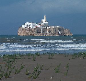
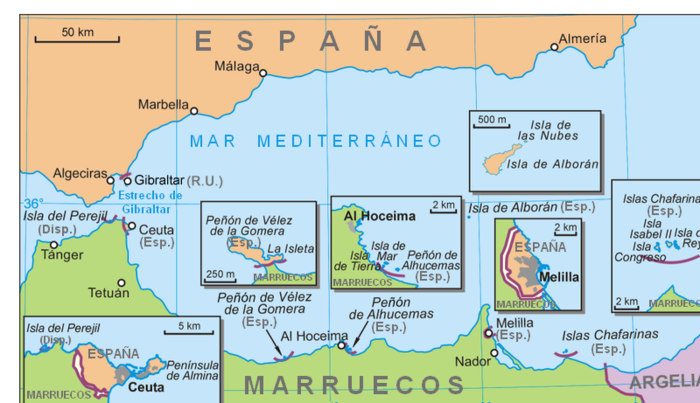
Peñón de Alhucemas and the islets of "Isla de Mar" and "Isla de Tierra" slightly to the west form the Alhucemas Islands. They are located 300 m (984 feet) off the Moroccan town of Al Hoceima
Al Hoceima
Al Hoceima is a city and port in the north of Morocco and in the center of the Rif Mountains. The Al Hoceima city region has a population of 395.644 and is the capital of the Taza-Al Hoceima-Taounate region...
or Alhucemas (former Villa Sanjurjo), 146 km (96 mi) east of Ceuta and 84 km (62 mi) west of Melilla.
Peñón de Alhucemas is a tiny rock island, measuring 220 meters east-west and up to 84 meters north-south, with an area 1.5 ha
Hectare
The hectare is a metric unit of area defined as 10,000 square metres , and primarily used in the measurement of land. In 1795, when the metric system was introduced, the are was defined as being 100 square metres and the hectare was thus 100 ares or 1/100 km2...
or 0.015 km², and a height of 27 meters (88 ft). The rock is entirely occupied by a fort, several houses, and a church.
Isla de Tierra is a steep, 11 m (33 ft) high rocky platform, 114 meters north of the Moroccan beach, 192 meters long northeast-southwest, and up to 87 meters wide, yielding an area of 1.7 ha
Hectare
The hectare is a metric unit of area defined as 10,000 square metres , and primarily used in the measurement of land. In 1795, when the metric system was introduced, the are was defined as being 100 square metres and the hectare was thus 100 ares or 1/100 km2...
or 0.017 km².
Isla de Mar is a flat, 4 m (12 ft) high islet, with its western end 93 meters north of Isla de Tierra, 245 meters long east-west, up to 70 meters wide, yielding an area of 1.4 ha
Hectare
The hectare is a metric unit of area defined as 10,000 square metres , and primarily used in the measurement of land. In 1795, when the metric system was introduced, the are was defined as being 100 square metres and the hectare was thus 100 ares or 1/100 km2...
or 0.014 km².
The aggregate land area of the group of three islands is 4.6 ha
Hectare
The hectare is a metric unit of area defined as 10,000 square metres , and primarily used in the measurement of land. In 1795, when the metric system was introduced, the are was defined as being 100 square metres and the hectare was thus 100 ares or 1/100 km2...
or 0.046 km².
Spanish rule dates back to 1559, when several territories belonging to the Saadi dynasty
Saadi Dynasty
The Saadi dynasty of Morocco , began with the reign of Sultan Mohammed ash-Sheikh in 1554, when he vanquished the last Wattasids at the Battle of Tadla....
were given to Spain in exchange for help in defending it against Ottoman
Ottoman Empire
The Ottoman EmpireIt was usually referred to as the "Ottoman Empire", the "Turkish Empire", the "Ottoman Caliphate" or more commonly "Turkey" by its contemporaries...
armies. In 1673, Spain sent a garrison to the island of Peñón de Alhucemas, and it has been permanently occupied since. Today, the fort which is built on it hosts a 60 man Spanish military garrison.
The islands are also located near the landing place used by the Spanish and French
France
The French Republic , The French Republic , The French Republic , (commonly known as France , is a unitary semi-presidential republic in Western Europe with several overseas territories and islands located on other continents and in the Indian, Pacific, and Atlantic oceans. Metropolitan France...
expeditionary forces in 1925, during the Rif War
Rif War (1920)
The Rif War, also called the Second Moroccan War, was fought between Spain and the Moroccan Rif Berbers.-Rifian forces:...
.
Spanish sovereignty over the islets has been contested by Morocco
Morocco
Morocco , officially the Kingdom of Morocco , is a country located in North Africa. It has a population of more than 32 million and an area of 710,850 km², and also primarily administers the disputed region of the Western Sahara...
since its independence in 1956.
See also
- Plazas de soberaníaPlazas de soberaníaThe plazas de soberanía or sovereign territories, referred to in English as Spanish North Africa or simply Spanish Africa, are the current Spanish territories in continental North Africa bordering Morocco, except the autonomous cities of Ceuta and Melilla.After the Reconquista, forces of the...
- List of Spanish colonial wars in Morocco
- Spanish MoroccoSpanish MoroccoThe Spanish protectorate of Morocco was the area of Morocco under colonial rule by the Spanish Empire, established by the Treaty of Fez in 1912 and ending in 1956, when both France and Spain recognized Moroccan independence.-Territorial borders:...

