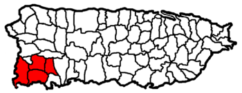
San Germán-Cabo Rojo metropolitan area
Encyclopedia

United States Census Bureau
The United States Census Bureau is the government agency that is responsible for the United States Census. It also gathers other national demographic and economic data...
defined Metropolitan Statistical Area (MSA) in southwestern Puerto Rico
Puerto Rico
Puerto Rico , officially the Commonwealth of Puerto Rico , is an unincorporated territory of the United States, located in the northeastern Caribbean, east of the Dominican Republic and west of both the United States Virgin Islands and the British Virgin Islands.Puerto Rico comprises an...
. A July 1, 2009 Census Bureau estimate placed the population at 148,559, a 9.06% increase over the 2000 census
United States Census, 2000
The Twenty-second United States Census, known as Census 2000 and conducted by the Census Bureau, determined the resident population of the United States on April 1, 2000, to be 281,421,906, an increase of 13.2% over the 248,709,873 persons enumerated during the 1990 Census...
figure of 136,212.
San Germán-Cabo Rojo is the fourth largest metropolitan area (by population) in Puerto Rico and is the second fastest growing MSA, after Aguadilla–Isabela–San Sebastián
Aguadilla-Isabela-San Sebastián metropolitan area
The Aguadilla-Isabela-San Sebastián Metropolitan Statistical Area is a United States Census Bureau defined Metropolitan Statistical Area in northwestern Puerto Rico...
, in the Commonwealth.
Municipalities
A total of four municipalities (SpanishSpanish language
Spanish , also known as Castilian , is a Romance language in the Ibero-Romance group that evolved from several languages and dialects in central-northern Iberia around the 9th century and gradually spread with the expansion of the Kingdom of Castile into central and southern Iberia during the...
: municipios) are included as part of the San Germán-Cabo Rojo Metropolitan Statistical Area. They are:
- Cabo RojoCabo Rojo, Puerto RicoCabo Rojo is a municipality situated on the southwest coast of Puerto Rico and forms part of the San Germán–Cabo Rojo metropolitan area as well as the larger Mayagüez–San Germán–Cabo Rojo Combined Statistical Area....
--Principal City - LajasLajas, Puerto RicoLajas is a municipality of Puerto Rico located in southwestern region, south of San Germán and Sabana Grande; east of Cabo Rojo; and west of Guánica. Lajas is spread over 11 wards and Lajas Pueblo...
- Sabana GrandeSabana Grande, Puerto RicoSabana Grande is a municipality of Puerto Rico located north of Lajas and Guánica; south of Maricao; east of San Germán; and west of Yauco. Sabana Grande is spread over seven wards and Sabana Grande Pueblo...
- San GermánSan Germán, Puerto RicoSan Germán is a municipality located in the southwestern region of Puerto Rico, south of Mayagüez and Maricao; north of Lajas; east of Hormigueros and Cabo Rojo; and west of Sabana Grande. San Germán is spread over 18 wards and San Germán Pueblo...
--Principal City
Combined Statistical Area
The San Germán-Cabo Rojo Metropolitan Statistical Area is a component of the MayagüezMayagüez, Puerto Rico
Mayagüez is the eighth-largest municipality of Puerto Rico. Originally founded as "Nuestra Señora de la Candelaria" it is also known as "La Sultana del Oeste" , "Ciudad de las Aguas Puras" , or "Ciudad del Mangó"...
–San Germán–Cabo Rojo Combined Statistical Area.

