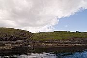
Slættanes
Encyclopedia

Vágar
Vágar is one of the 18 islands in the archipelago of the Faroe Islands and the most westerly of the large islands. With a size of 178 km² , it ranks number three, behind Streymoy and Eysturoy....
in the Faroes, which is now abandoned.
Slættanes, like the also abandoned village of Víkar
Víkar, Faroe Islands
Víkar is an abandoned town in the Faroe Islands on the north coast of the Island of Vágar.Víkar was founded in 1833 and belonged to the village of Gásadalur farther south. Even today a path still connects the two communities with each other. Even though the landscape was very favorable, Víkar had...
, on the northern coast of the island. It was founded in 1835 by a man named Hendrik Thomasen and belonged to the municipality of Sandavágur
Sandavágur
The town of Sandavágur lies on the south coast of the Faroese island of Vágar, and has been voted the most well-kept village in the Faroes twice. The name Sandavágur means sandy creek and refers to the beach down by the inlet. From one point in Sandavágur you can get a view of all the southern...
in the south. During its best years (1945 to 1950) around 130 people lived in the village, but the average population was around 70. There were 12 houses in Slættanes. However, in 1965 the last inhabitants left the community because of its relatively isolated location.
A road was never built to Slættanes, but there are many trails there. One goes to Sandavágur in the southeast, another to Sørvágur
Sørvágur
Sørvágur is a village on the island of Vágoy in the Faroe Islands. It is located at the landward end of Sørvágsfjørður. Sørvágur is the largest village in the municipality of Sørvágs Kommuna.-Name:...
to the south, and yet another goes west to Gásadalur
Gásadalur
Gásadalur is located on the west-side of Vágar, Faroe Islands, and enjoys a panoramic view over the island of Mykines.Gásadalur is located on the edge of Mykinesfjørður, surrounded by the highest mountains on Vágar. Árnafjall towers to a height of 722 metres to the north, and Eysturtindur to the...
. In the village itself there are no streets or discernible paths. The houses stand dispersed across the meadow and now serve as summer houses for the former residents and their relatives.
Postal service once arrived by foot from Sørvágur, and then later by a regular boat service from Vestmanna
Vestmanna
Vestmanna is a town in the Faroe Islands on the west of the island of Streymoy. It was formerly a ferry port, until an undersea tunnel was built from Vágar to Kvívík and Stykkið. The cliffs west of Vestmanna, Vestmannabjørgini are very popular for excursions by boat.A 'Vestmann' was a "Westman",...
.

