St. Marys River (Indiana)
Encyclopedia

Maumee River
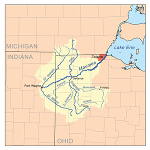
The Maumee River is a river in northwestern Ohio and northeastern Indiana in the United States. It is formed at Fort Wayne, Indiana by the confluence of the St. Joseph and St. Marys rivers, and meanders northeastwardly for through an agricultural region of glacial moraines before flowing into the...
in western Ohio
Ohio
Ohio is a Midwestern state in the United States. The 34th largest state by area in the U.S.,it is the 7th‑most populous with over 11.5 million residents, containing several major American cities and seven metropolitan areas with populations of 500,000 or more.The state's capital is Columbus...
and eastern Indiana
Indiana
Indiana is a US state, admitted to the United States as the 19th on December 11, 1816. It is located in the Midwestern United States and Great Lakes Region. With 6,483,802 residents, the state is ranked 15th in population and 16th in population density. Indiana is ranked 38th in land area and is...
in the United States
United States
The United States of America is a federal constitutional republic comprising fifty states and a federal district...
. Prior to development, it was part of the Great Black Swamp
Great Black Swamp
The Great Black Swamp, or simply Black Swamp, was a glacially caused wetland in northwest Ohio, United States, extending into extreme northeastern Indiana, that existed from the end of the Wisconsin glaciation until the late 19th century...
. Today, it drains a primarily rural farming region in the watershed of Lake Erie
Lake Erie
Lake Erie is the fourth largest lake of the five Great Lakes in North America, and the tenth largest globally. It is the southernmost, shallowest, and smallest by volume of the Great Lakes and therefore also has the shortest average water residence time. It is bounded on the north by the...
.
It is formed in southern Auglaize County
Auglaize County, Ohio
As of the census of 2000, there were 46,611 people, 17,376 households, and 12,771 families residing in the county. The population density was 116 people per square mile . There were 18,470 housing units at an average density of 46 per square mile...
in western Ohio by the confluence of the short East Branch and Center Branch. It flows briefly west to St. Marys
St. Marys, Ohio
St. Marys is a city in Auglaize County, Ohio, United States. The population was 8,342 at the 2000 census. It is included in the Wapakoneta, Ohio, Micropolitan Statistical Area.-History:...
, approaching to within two miles of Grand Lake before turning to the north. In northwestern Auglaize County it turns sharply to the west-northwest, flowing past Rockford
Rockford, Ohio
Rockford is a village in Mercer County, Ohio, United States. The population was 1,126 at the 2000 census.-Geography:Rockford is located at ....
and Willshire
Willshire, Ohio
Willshire is a village in Van Wert County, Ohio, United States. The population was 463 at the 2000 census. It is included within the Van Wert, Ohio Micropolitan Statistical Area.-History:...
into Adams County, Indiana
Adams County, Indiana
Adams County lies in northeastern Indiana in the United States and shares its eastern border with Ohio. It was officially established in 1836. The county seat is Decatur....
. In northeastern Indiana it flows northwest past Decatur
Decatur, Indiana
Decatur is a city in Root and Washington townships, Adams County, Indiana, United States. The city, which serves as the county seat of Adams County, takes its name after the prominent war hero Stephen Decatur, Jr., one of the captains of the original 6 frigates of the US navy...
, then enters Fort Wayne
Fort Wayne, Indiana
Fort Wayne is a city in the US state of Indiana and the county seat of Allen County. The population was 253,691 at the 2010 Census making it the 74th largest city in the United States and the second largest in Indiana...
. It hooks around in its last half mile (0.8 km) to join the St. Joseph River
St. Joseph River (Maumee River)
The St. Joseph River is an tributary of the Maumee River in northwestern Ohio, and northeastern Indiana in the United States, with headwater tributaries rising in southern Michigan. It drains a primarily rural farming region in the watershed of Lake Erie. It shares its name with the St...
from the west to form the Maumee in downtown Fort Wayne.
The World War II
World War II
World War II, or the Second World War , was a global conflict lasting from 1939 to 1945, involving most of the world's nations—including all of the great powers—eventually forming two opposing military alliances: the Allies and the Axis...
-era US Navy vessel St. Mary's River
USS St. Mary's River (LSM(R)-528)
USS St. Mary's River was originally authorized as LSM-528. Reclassified LSM-528 on 21 April 1945, she was laid down on 19 May 1945 at the Brown Shipbuilding Co., Inc., Houston, Texas, launched on 16 June 1945, and commissioned on 2 September 1945, Lieutenant Norman E...
was named after this river.

