

Trnavské mýto
Encyclopedia


Intersection (road)
An intersection is a road junction where two or more roads either meet or cross at grade . An intersection may be 3-way - a T junction or fork, 4-way - a crossroads, or 5-way or more...
in Bratislava
Bratislava
Bratislava is the capital of Slovakia and, with a population of about 431,000, also the country's largest city. Bratislava is in southwestern Slovakia on both banks of the Danube River. Bordering Austria and Hungary, it is the only national capital that borders two independent countries.Bratislava...
, Slovakia
Slovakia
The Slovak Republic is a landlocked state in Central Europe. It has a population of over five million and an area of about . Slovakia is bordered by the Czech Republic and Austria to the west, Poland to the north, Ukraine to the east and Hungary to the south...
, in the Nové Mesto
Nové Mesto, Bratislava
Nové Mesto is a borough of Bratislava, in the Bratislava III district. It is located north and north-east of the Old Town. The borough also borders Rača, Vajnory, Ružinov, Lamač and Záhorská Bystrica boroughs.-History:...
district. It is located at 48°9′30"N 17°07′41"E.
Description
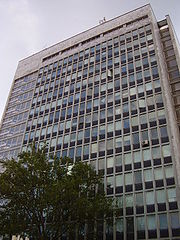
The area includes a square, home to Dom odborov Istropolis on the north side and a market hall (tržnica) on the south. In addition to the streets listed below, Trnavské mýto is crossed by tram lines from the city center heading both northeast on Vajnorská toward VajnoryVajnory
Vajnory is a small borough in the northeast of Bratislava, Slovakia.Milan Rastislav Štefánik international airport is located near Vajnory. Another airport - Vajnory Airport, which was the first airport in Slovakia - closed in 2006.-History:...
and east via Miletičova toward Ružinov
Ružinov
Ružinov is a borough of eastern Bratislava. It is the city's second most populated borough, housing over 70,000 inhabitants.-History:In place of today's Ružinov there were originally meadows, pastures, grasslands and woodland, interspersed with islands and channels of the Danube. The people living...
, as well as trolleybus lines from the east and west and bus service in all directions.
A pedestrian subway
Subway (underpass)
In England and Wales, the Republic of Ireland, Hong Kong and some Commonwealth countries , the term subway normally refers to a specially constructed underpass for pedestrians and/or cyclists beneath a road or railway, allowing them to reach the other side in safety.The term is also used in the...
links the corners of the intersection with the tram stops, and includes several small shops.
History
Trnavské mýto takes its name from its situation on the road connecting BratislavaBratislava
Bratislava is the capital of Slovakia and, with a population of about 431,000, also the country's largest city. Bratislava is in southwestern Slovakia on both banks of the Danube River. Bordering Austria and Hungary, it is the only national capital that borders two independent countries.Bratislava...
to Trnava
Trnava
Trnava is a city in western Slovakia, 47 km to the north-east of Bratislava, on the Trnávka river. It is the capital of a kraj and of an okres . It was the seat of a Roman Catholic archbishopric . The city has a historic center...
("Trnavská") and from the toll point ("mýto"), though no tolls are collected there.
Formerly, a large marketplace was located here but was later moved to Miletičova ulica.
- 1783: Marketplace
- 1820: Cattle market, pub
- 1973: Construction of the Dom odborov office tower
- 1975: Underpass constructed; marketplace relocated
- 1981: Construction of Istropolis cultural center
Connecting streets
- Šancová StreetŠancová StreetŠancová Street is a major street in Bratislava's Old Town, extending from the intersection of Štefánikova ulica and Pražská ulica to Trnavské mýto. It is a significant transport artery, and site of frequent traffic congestion.- Origin of the name :...
to the west, toward Račianske mýtoRacianske mýtoRačianske mýto is a major transport junction and intersection in Bratislava, Slovakia, at the border of the Staré Mesto and Nové Mesto districts... - Trnavská cesta to the east, toward TrnavaTrnavaTrnava is a city in western Slovakia, 47 km to the north-east of Bratislava, on the Trnávka river. It is the capital of a kraj and of an okres . It was the seat of a Roman Catholic archbishopric . The city has a historic center...
- Vajnorská Street to the northeast, toward VajnoryVajnoryVajnory is a small borough in the northeast of Bratislava, Slovakia.Milan Rastislav Štefánik international airport is located near Vajnory. Another airport - Vajnory Airport, which was the first airport in Slovakia - closed in 2006.-History:...
- Krížna Street to the southwest, toward the Old TownOld Town, BratislavaThe Old Town of Bratislava is the historic center and one of the boroughs of Bratislava, in the Bratislava Region of Slovakia. It is coextensive with the smallest Slovak administrative district by area, Bratislava I. It contains the small, but preserved medieval city center, Bratislava Castle and...