
Viðareiði
Encyclopedia
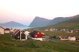
Viðareiði is the northernmost settlement in the Faroe Islands
and lies on the Island of Viðoy
, which belongs to the Norðoyar
Region. It lies on an isthmus
with high mountains to both the north and south.
The community is linked overland by a dam and tunnel system to the regional center of Klaksvík
on Borðoy
. The road to Viðareiði goes along the west coast of Viðoy, through the town, and then along the island's east coast to the uninhabited Miðdalur Valley with its typical small waterfall.
To the north, Mount Villingdalsfjall rises over 844 metres (2,769 ft) from the water. It is the highest mountain in the North Islands and the third-largest in the entire Faroese archipelago. The north coast is marked by Cape Enniberg
, the second highest sea cliff in Europe at 754 metres (2,473.8 ft). Looking to the west from Viðareiði, one has a view of the mighty northern peaks of Borðoy
and Kunoy
. Turning around, one can see through the crag and tail
s of the isthmus to the eastern Island of Fugloy
. Finally, to the south of the town, the 751 metres (2,463.9 ft) high cone-shaped mountain of Malinsfjall can be seen during good weather. Viðareiði is a departure point for a vast area of hiking. In the community, there is not only a small grocery store, but also the Hotel Norð with its restaurant that serves traditional cuisine.
and reburied in Viðareiði.
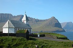 The current church was built in 1892. The church silver is a gift from the British government, thanking the Viðareiði's citizens for the rescue of the Brig
Marwood, which was shiprecked near Viðareiði during a winter storm in 1847.
Faroe Islands
The Faroe Islands are an island group situated between the Norwegian Sea and the North Atlantic Ocean, approximately halfway between Scotland and Iceland. The Faroe Islands are a self-governing territory within the Kingdom of Denmark, along with Denmark proper and Greenland...
and lies on the Island of Viðoy
Viðoy
Viðoy is the northern-most island in the Faroe Islands, located east of Borðoy to which it is linked via a causeway. The name means wood island, despite the fact that no trees grow on the island: the name relates to the driftwood that floats in from Siberia and North America.- Geography :The...
, which belongs to the Norðoyar
Norðoyar
The six islands in the northeast of the Faroe Islands are together referred to as Norðoyar, i.e. the Northern Isles . These Islands are Kalsoy, Kunoy, Borðoy, Viðoy, Svínoy and Fugloy. Klaksvík is regarded as the natural capital of this region. Norðoyar is sometimes spelled Norðoyggjar.-Further...
Region. It lies on an isthmus
Isthmus
An isthmus is a narrow strip of land connecting two larger land areas usually with waterforms on either side.Canals are often built through isthmuses where they may be particularly advantageous to create a shortcut for marine transportation...
with high mountains to both the north and south.
The community is linked overland by a dam and tunnel system to the regional center of Klaksvík
Klaksvík
Klaksvík is the second largest town of the Faroe Islands.The town is located on Borðoy, which is one of the northernmost islands ....
on Borðoy
Borðoy
Borðoy is an island in the north-east of the Faroe Islands. There are eight settlements: Klaksvík , Norðoyri, Ánir, Árnafjørður, Strond, Norðtoftir, Depil and Norðdepil. There are also three abandoned settlements: Skálatoftir, Múli and Fossá, all in the north...
. The road to Viðareiði goes along the west coast of Viðoy, through the town, and then along the island's east coast to the uninhabited Miðdalur Valley with its typical small waterfall.
To the north, Mount Villingdalsfjall rises over 844 metres (2,769 ft) from the water. It is the highest mountain in the North Islands and the third-largest in the entire Faroese archipelago. The north coast is marked by Cape Enniberg
Cape Enniberg
Cape Enniberg is the northernmost point of the Faroe Islands, located on the Island of Viðoy. It is 754 m above sea level, altitude that makes it the second highest sea-cliff in Europe ....
, the second highest sea cliff in Europe at 754 metres (2,473.8 ft). Looking to the west from Viðareiði, one has a view of the mighty northern peaks of Borðoy
Borðoy
Borðoy is an island in the north-east of the Faroe Islands. There are eight settlements: Klaksvík , Norðoyri, Ánir, Árnafjørður, Strond, Norðtoftir, Depil and Norðdepil. There are also three abandoned settlements: Skálatoftir, Múli and Fossá, all in the north...
and Kunoy
Kunoy
Kunoy is an island located in the north-east of the Faroe Islands between Kalsoy and Borðoy .- Settlements and transport :...
. Turning around, one can see through the crag and tail
Crag and tail
A crag is a rocky hill or mountain, generally isolated from other high ground. Crags are formed when a glacier or ice sheet passes over an area that contains a particularly resistant rock formation...
s of the isthmus to the eastern Island of Fugloy
Fugloy
Fugloy is the eastern-most island in the Faroe Islands. The name means bird island, and refers to the large number of birds that nest on the island's cliffs.- Geography :...
. Finally, to the south of the town, the 751 metres (2,463.9 ft) high cone-shaped mountain of Malinsfjall can be seen during good weather. Viðareiði is a departure point for a vast area of hiking. In the community, there is not only a small grocery store, but also the Hotel Norð with its restaurant that serves traditional cuisine.
History
In the 17th century, the old church was destroyed in a storm. It is said that a part of the cemetery was washed away by the sea and that coffins from the cemetery were recovered in HvannasundHvannasund
Hvannasund is a village and municipality in the Faroe Islands, an autonomous region in Denmark....
and reburied in Viðareiði.
Brig
A brig is a sailing vessel with two square-rigged masts. During the Age of Sail, brigs were seen as fast and manoeuvrable and were used as both naval warships and merchant vessels. They were especially popular in the 18th and early 19th centuries...
Marwood, which was shiprecked near Viðareiði during a winter storm in 1847.