
Zook's Mill Covered Bridge
Encyclopedia
Zook's Mill Covered Bridge is a covered bridge
that spans Cocalico Creek
in Lancaster County
, Pennsylvania
, United States
. A county-owned and maintained bridge, its official designation is the Cocalico #7 Bridge. The bridge is also known as Wenger Covered Bridge or Rose Hill Covered Bridge. It is located west of Brownstown
on T 797, near the Warwick
and West Earl
Townships.
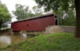
The bridge has a single span, wooden, double Burr arch trusses design with the addition of steel hanger rods. The deck is made from oak planks. It is painted red, the traditional color of Lancaster County covered bridges, on both the inside and outside. Both approaches to the bridge are painted red with white trim.
The bridge is 74 feet long and 13 feet three inches wide. It has a wooden burr type truss
and was built in 1849 by Henry Zook. Unlike many other bridges in the county the bridge withstood Hurricane Agnes
, despite being filled with 6-and-a-half feet of water. It is also known as the Wenger Covered Bridge, the Rose Hill Covered Bridge, and the Cocalico #7 Bridge.
The bridge's WGCB
Number is 38-36-14. Added in 1980, it is listed on the National Register of Historic Places
as structure number 80003508. It is located at 40°7′48.6"N 76°13′54.6"W (40.13017, -76.23183).
Covered bridge
A covered bridge is a bridge with enclosed sides and a roof, often accommodating only a single lane of traffic. Most covered bridges are wooden; some newer ones are concrete or metal with glass sides...
that spans Cocalico Creek
Cocalico Creek
Cocalico Creek is a tributary of the Conestoga River in Lebanon and Lancaster counties in Pennsylvania in the United States. The source is at an elevation of near Stricklerstown in Millcreek Township, Lebanon County...
in Lancaster County
Lancaster County, Pennsylvania
Lancaster County, known as the Garden Spot of America or Pennsylvania Dutch Country, is a county located in the southeastern part of the Commonwealth of Pennsylvania, in the United States. As of 2010 the population was 519,445. Lancaster County forms the Lancaster Metropolitan Statistical Area, the...
, Pennsylvania
Pennsylvania
The Commonwealth of Pennsylvania is a U.S. state that is located in the Northeastern and Mid-Atlantic regions of the United States. The state borders Delaware and Maryland to the south, West Virginia to the southwest, Ohio to the west, New York and Ontario, Canada, to the north, and New Jersey to...
, United States
United States
The United States of America is a federal constitutional republic comprising fifty states and a federal district...
. A county-owned and maintained bridge, its official designation is the Cocalico #7 Bridge. The bridge is also known as Wenger Covered Bridge or Rose Hill Covered Bridge. It is located west of Brownstown
Brownstown, Pennsylvania
Brownstown is the name of more than one place in the U.S. state of Pennsylvania:*Brownstown, Armstrong County, Pennsylvania*Brownstown, Cambria County, Pennsylvania*Brownstown, Fayette County, Pennsylvania*Brownstown, Lancaster County, Pennsylvania...
on T 797, near the Warwick
Warwick Township, Lancaster County, Pennsylvania
Warwick Township is a township in north central Lancaster County, Pennsylvania, United States. The population was 15,475 at the 2000 census.-Geography:...
and West Earl
West Earl Township, Pennsylvania
West Earl Township is a township in northeastern Lancaster County, Pennsylvania, United States. The population was 6,766 at the 2000 census.Floyd Landis, winner of the 2006 Tour de France, is from the unincorporated village of Farmersville in West Earl Township.-Geography:According to the United...
Townships.
The bridge has a single span, wooden, double Burr arch trusses design with the addition of steel hanger rods. The deck is made from oak planks. It is painted red, the traditional color of Lancaster County covered bridges, on both the inside and outside. Both approaches to the bridge are painted red with white trim.
The bridge is 74 feet long and 13 feet three inches wide. It has a wooden burr type truss
Truss
In architecture and structural engineering, a truss is a structure comprising one or more triangular units constructed with straight members whose ends are connected at joints referred to as nodes. External forces and reactions to those forces are considered to act only at the nodes and result in...
and was built in 1849 by Henry Zook. Unlike many other bridges in the county the bridge withstood Hurricane Agnes
Hurricane Agnes
Hurricane Agnes was the first tropical storm and first hurricane of the 1972 Atlantic hurricane season. A rare June hurricane, it made landfall on the Florida Panhandle before moving northeastward and ravaging the Mid-Atlantic region as a tropical storm...
, despite being filled with 6-and-a-half feet of water. It is also known as the Wenger Covered Bridge, the Rose Hill Covered Bridge, and the Cocalico #7 Bridge.
The bridge's WGCB
World Guide to Covered Bridges
The World Guide to Covered Bridges is a covered bridge numbering system. The system was invented by John Diehl, the chairman of the Ohio Covered Bridge Committee. The committee first used the numbering system in 1953 to publish a list of covered bridges in Ohio....
Number is 38-36-14. Added in 1980, it is listed on the National Register of Historic Places
National Register of Historic Places
The National Register of Historic Places is the United States government's official list of districts, sites, buildings, structures, and objects deemed worthy of preservation...
as structure number 80003508. It is located at 40°7′48.6"N 76°13′54.6"W (40.13017, -76.23183).
Dimensions
- Length: 74 feetFtFt or ft. may mean:* Foot , a unit of distance or length* Hungarian forint, the currency of Hungary* Fair Trade, the principle to give a fair price when trading* Fort, a fortified place, especially in place names...
(22.6 m) spanSpan (architecture)Span is the distance between two intermediate supports for a structure, e.g. a beam or a bridge.A span can be closed by a solid beam or of a rope...
and 89 feet (27.1 m) total length - Width: 13 feet 3 inches (4.0 m) clear deck and 15 feet (4.6 m) total width
- Overhead clearance: 11 feet 6 inches (3.5 m)
- Underclearance: 9 feet 6 inches (2.9 m)