
1929 Grand Banks earthquake
Encyclopedia
The 1929 Grand Banks earthquake, also called the Laurentian Slope earthquake and the South Shore Disaster, was a magnitude
7.2 earthquake
that occurred on November 18, 1929 in the Atlantic Ocean off the south coast of Newfoundland
in the Laurentian Slope Seismic Zone
.
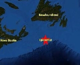
The earthquake was centred on the edge of the Grand Banks of Newfoundland, about 400 kilometres (248.5 mi) south of the island. It was felt as far away as New York and Montreal. The quake, along two faults 250 kilometres (155.3 mi) south of the Burin Peninsula
, triggered a large submarine landslide (200 km³ (48 cu mi)). It snapped 12 submarine transatlantic telegraph cable
s and led to a tsunami
that arrived in three waves, each 3 to 4 metres high, that struck the coast at 105 km/h (65.2 mph) about three hours after the earthquake occurred. The waves travelled at speeds up to 129 km/h (80.2 mph) at the epicentre; they were recorded as far away as Portugal.
The tsunami destroyed many south coastal communities on the Burin Peninsula, killing 28 people and leaving 10,000 more homeless. All means of communication were cut off by the destruction, and relief efforts were further hampered by a blizzard that struck the day after. It took more than three days before the SS Meigle responded to an SOS signal with doctors, nurses, blankets, and food. Donations from across Newfoundland, Canada, the United States and United Kingdom totalled $250,000.
, it is the only recorded tsunami to have struck Canada's east coast.
. Scientists are looking at layers of sand believed to be deposited by other tsunamis in an effort to determine the occurrence rates of large earthquakes. One sand layer, thought to be deposited by the 1929 tsunami, at Taylor's Bay was found 13 cm below the turf line. The occurrences of large tsunamis, such as the one in 1929, are dependent upon deposition of sediments offshore because it was the landslide, which made the tsunami so powerful. The deposition of such a large volume of sediments will take a while before there is enough to form an underwater landslide of size as in 1929.
Moment magnitude scale
The moment magnitude scale is used by seismologists to measure the size of earthquakes in terms of the energy released. The magnitude is based on the seismic moment of the earthquake, which is equal to the rigidity of the Earth multiplied by the average amount of slip on the fault and the size of...
7.2 earthquake
Earthquake
An earthquake is the result of a sudden release of energy in the Earth's crust that creates seismic waves. The seismicity, seismism or seismic activity of an area refers to the frequency, type and size of earthquakes experienced over a period of time...
that occurred on November 18, 1929 in the Atlantic Ocean off the south coast of Newfoundland
Dominion of Newfoundland
The Dominion of Newfoundland was a British Dominion from 1907 to 1949 . The Dominion of Newfoundland was situated in northeastern North America along the Atlantic coast and comprised the island of Newfoundland and Labrador on the continental mainland...
in the Laurentian Slope Seismic Zone
Laurentian Slope Seismic Zone
The Laurentian Slope Seismic Zone is a seismically active area in Atlantic Canada located on the Grand Banks of Newfoundland. It was the epicenter of the magnitude 7.2 1929 Grand Banks earthquake. Since then, more than 20 relatively minor earthquakes have occurred....
.
The earthquake was centred on the edge of the Grand Banks of Newfoundland, about 400 kilometres (248.5 mi) south of the island. It was felt as far away as New York and Montreal. The quake, along two faults 250 kilometres (155.3 mi) south of the Burin Peninsula
Burin Peninsula
The Burin Peninsula is a Canadian peninsula located on the south coast of the island of Newfoundland in the province of Newfoundland and Labrador....
, triggered a large submarine landslide (200 km³ (48 cu mi)). It snapped 12 submarine transatlantic telegraph cable
Transatlantic telegraph cable
The transatlantic telegraph cable was the first cable used for telegraph communications laid across the floor of the Atlantic Ocean. It crossed from , Foilhommerum Bay, Valentia Island, in western Ireland to Heart's Content in eastern Newfoundland. The transatlantic cable connected North America...
s and led to a tsunami
Tsunami
A tsunami is a series of water waves caused by the displacement of a large volume of a body of water, typically an ocean or a large lake...
that arrived in three waves, each 3 to 4 metres high, that struck the coast at 105 km/h (65.2 mph) about three hours after the earthquake occurred. The waves travelled at speeds up to 129 km/h (80.2 mph) at the epicentre; they were recorded as far away as Portugal.
The tsunami destroyed many south coastal communities on the Burin Peninsula, killing 28 people and leaving 10,000 more homeless. All means of communication were cut off by the destruction, and relief efforts were further hampered by a blizzard that struck the day after. It took more than three days before the SS Meigle responded to an SOS signal with doctors, nurses, blankets, and food. Donations from across Newfoundland, Canada, the United States and United Kingdom totalled $250,000.
, it is the only recorded tsunami to have struck Canada's east coast.
Aftermath and research
In 1952 American scientists from Columbia University put together the pieces of the sequentially broken cables that led to discovery of the landslide and the first documentation of a turbidity currentTurbidity current
A turbidity current is a current of rapidly moving, sediment-laden water moving down a slope through water, or another fluid. The current moves because it has a higher density and turbidity than the fluid through which it flows...
. Scientists are looking at layers of sand believed to be deposited by other tsunamis in an effort to determine the occurrence rates of large earthquakes. One sand layer, thought to be deposited by the 1929 tsunami, at Taylor's Bay was found 13 cm below the turf line. The occurrences of large tsunamis, such as the one in 1929, are dependent upon deposition of sediments offshore because it was the landslide, which made the tsunami so powerful. The deposition of such a large volume of sediments will take a while before there is enough to form an underwater landslide of size as in 1929.
External links
- Tsunami: The Newfoundland Tidal Wave Disaster - Maura HanrahanMaura HanrahanMaura Hanrahan is a Canadian author.She is the author of Tsunami, which tells the story of a 1929 tidal wave in Newfoundland. The book received the Heritage and History Award and was short-listed for the 2005 Newfoundland and Labrador Book Award for Non-fiction...
(2004) ISBN 1-894463-63-3 - The Magnitude 7.2 1929 "Grand Banks" earthquake and tsunami - Natural Resources Canada
- The South Shore disaster: Newfoundland's tsunami
- Not Too Long Ago (first hand accounts of the tsunami, pp. 51-60)