
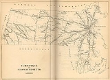
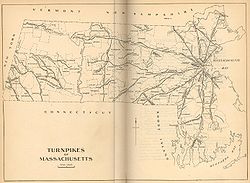
19th century turnpikes in Massachusetts
Encyclopedia
Massachusetts
The Commonwealth of Massachusetts is a state in the New England region of the northeastern United States of America. It is bordered by Rhode Island and Connecticut to the south, New York to the west, and Vermont and New Hampshire to the north; at its east lies the Atlantic Ocean. As of the 2010...
began in 1796, when the first act of incorporation for a turnpike was passed. By 1850, most turnpike corporations had either been dissolved or had stopped collecting tolls. In all, 118 acts of incorporation were passed (ten of these were in the territory that later became the state of Maine
Maine
Maine is a state in the New England region of the northeastern United States, bordered by the Atlantic Ocean to the east and south, New Hampshire to the west, and the Canadian provinces of Quebec to the northwest and New Brunswick to the northeast. Maine is both the northernmost and easternmost...
). Typical toll rates were twenty-five cents for every coach with additional charges of four cents for every man and horse.
List of turnpikes
The following 19th century turnpikesToll road
A toll road is a privately or publicly built road for which a driver pays a toll for use. Structures for which tolls are charged include toll bridges and toll tunnels. Non-toll roads are financed using other sources of revenue, most typically fuel tax or general tax funds...
were chartered and built in Massachusetts
Massachusetts
The Commonwealth of Massachusetts is a state in the New England region of the northeastern United States of America. It is bordered by Rhode Island and Connecticut to the south, New York to the west, and Vermont and New Hampshire to the north; at its east lies the Atlantic Ocean. As of the 2010...
:
| Turnpike name | General routing | Dates of operation | Modern designation |
|---|---|---|---|
| First Massachusetts Turnpike | North Wilbraham–Palmer–Warren | 1796–1819 | U.S. Route 20–Old Warren Road–Route 67 |
| Second Massachusetts Turnpikehttp://catskillarchive.com/rrextra/httpk2nd.Html | North Adams–Drury–Charlemont | 1797–1833 | Route 2 Route 2 (Massachusetts) Route 2 is a major east–west state highway in Massachusetts, parts of which are sometimes known as the Cambridge and Concord Turnpike. Along with Route 9 and U.S. Route 20 to the south, these highways are the main alternatives to the Massachusetts Turnpike/I-90 toll highway... |
| Third Massachusetts Turnpike | Pittsfield line–Worthington–Northampton | 1797–1829 | Grange Hall Road/Robinson Road–Route 143–East Street/Chesterfield Road |
| Williamstown Turnpike | New York state line–Williamstown–North Adams | Route 2 Route 2 (Massachusetts) Route 2 is a major east–west state highway in Massachusetts, parts of which are sometimes known as the Cambridge and Concord Turnpike. Along with Route 9 and U.S. Route 20 to the south, these highways are the main alternatives to the Massachusetts Turnpike/I-90 toll highway... |
|
| Fifth Massachusetts Turnpike Fifth Massachusetts Turnpike The Fifth Massachusetts Turnpike was one of over 60 toll roads in operation throughout Massachusetts in the first half of the 19th century. An act establishing the Corporation was approved by the Massachusetts legislature on March 1, 1799. The Preamble to the act reads:-Route:The eastern terminus... |
Greenfield–Athol–Leominster–Concord (with branch from Athol to Northfield) |
1799–1832 | Route 2 Route 2 (Massachusetts) Route 2 is a major east–west state highway in Massachusetts, parts of which are sometimes known as the Cambridge and Concord Turnpike. Along with Route 9 and U.S. Route 20 to the south, these highways are the main alternatives to the Massachusetts Turnpike/I-90 toll highway... |
| Sixth Massachusetts Turnpike | Amherst–Greenwich–Oakham–Shrewsbury | 1799–1829 | Local roads west of Rutland and east of Holden; Route 122A (Rutland-Holden). Pelham-Greenwich is now under the Quabbin Reservoir Quabbin Reservoir The Quabbin Reservoir is the largest inland body of water in the Commonwealth of Massachusetts and was built between 1930 and 1939. Today along with the Wachusett Reservoir, it is the primary water supply for Boston, some to the east, as well as 40 other communities in Greater Boston... . |
| Eighth Massachusetts Turnpike | Becket–Chester–Russell | 1800–1844 | U.S. Route 20 U.S. Route 20 U.S. Route 20 is an east–west United States highway. As the "0" in its route number implies, US 20 is a coast-to-coast route. Spanning , it is the longest road in the United States, and the route sparsely parallels Interstate 90... |
| Ninth Massachusetts Turnpike | Douglas–Mendon–Bellingham | 1800–1833 | Southwest Main Street–Hartford Avenue (old Middle Post Road) |
| Tenth Massachusetts Turnpike | New York line–Lenox–Becket–Sandisfield–Connecticut line | 1800–1855 | Route 8–U.S. Route 20 U.S. Route 20 U.S. Route 20 is an east–west United States highway. As the "0" in its route number implies, US 20 is a coast-to-coast route. Spanning , it is the longest road in the United States, and the route sparsely parallels Interstate 90... –local streets north of Lenox |
| Third New Hampshire Turnpike | New Hampshire line–Townsend | 1801–1826 | Old Turnpike Road (connects to New Hampshire Route 124 New Hampshire Route 124 New Hampshire Route 124 is a long east–west highway in southern New Hampshire. It runs from Marlborough to the Massachusetts border.... ) |
| Twelfth Massachusetts Turnpike | Egremont–Sheffield—Connecticut line | 1801–1857 | U.S. Route 7 U.S. Route 7 U.S. Route 7 is a north–south United States highway in western New England that runs for from Norwalk, Connecticut, to Highgate, Vermont. The highway's southern terminus is at Interstate 95 in Norwalk, Connecticut... –Egremont Road–Route 23 Route 23 (Massachusetts) Route 23 is a west–east route in the western Massachusetts counties of Berkshire and Hampden. The entire route is . The vast majority of the road follows the Knox Trail, the historic route of General Henry Knox took to bring cannon from Fort Ticonderoga on Lake Champlain in New York to aid... |
| Salem Turnpike | Boston–Lynn–Salem | 1802–1868 | Broadway–Route 107 |
| Norfolk and Bristol Turnpike | Dedham | Washington Street Washington Street (Boston) Washington Street is a street originating in downtown Boston, Massachusetts that extends southwestward to the Massachusetts-Rhode Island state line. The majority of it was built as the Norfolk and Bristol Turnpike in the early nineteenth century... –US 1 U.S. Route 1 in Massachusetts In the U.S. state of Massachusetts, U.S. Route 1 is a major north–south state highway through Boston. The portion of US 1 south of Boston is also known as the Boston-Providence Turnpike, and portions north of the city are known as the Northeast Expressway and the Newburyport Turnpike.-Route... -MA 1A Route 1A (Massachusetts) Route 1A is a south–north state highway in Massachusetts. It is an alternate route to U.S. 1 with three signed sections and two unsigned sections where the highway is concurrent with its parent... |
| Name | Location | Modern Designation |
|---|---|---|
| Quincy Turnpike | Quincy Quincy, Massachusetts Quincy is a city in Norfolk County, Massachusetts, United States. Its nicknames are "City of Presidents", "City of Legends", and "Birthplace of the American Dream". As a major part of Metropolitan Boston, Quincy is a member of Boston's Inner Core Committee for the Metropolitan Area Planning Council... |
|
| Fourteenth Massachusetts Turnpike | Shelburne Shelburne, Massachusetts Shelburne is a town in Franklin County, Massachusetts, United States. The population was 2,058 at the 2000 census. It is part of the Springfield, Massachusetts Metropolitan Statistical Area.The village of Shelburne Falls is located in the town.- History :... |
|
| Camden Turnpike | Camden, Maine Camden, Maine Camden is a town in Knox County, Maine, United States. The population was 5,254 at the 2000 census. The population of the town more than triples during the summer months, due to tourists and summer residents. Camden is a famous summer colony in the Mid-Coast region of Maine... |
|
| First Cumberland Turnpike | Cumberland, Maine Cumberland, Maine Cumberland is a town in Cumberland County, Maine, United States. The population was 7,211 at the 2010 census. It is part of the Portland–South Portland–Biddeford, Maine Metropolitan Statistical Area.-History:... |
|
| Belchertown and Greenwich Turnpike | Belchertown Belchertown, Massachusetts As of the census of 2000, there were 12,968 people, 4,886 households, and 3,517 families residing in the town. The population density was 245.9 people per square mile . There were 5,050 housing units at an average density of 95.8 per square mile... |
|
| Fifteenth Massachusetts Turnpike | Great Barrington Great Barrington, Massachusetts Great Barrington is a town in Berkshire County, Massachusetts, United States. It is part of the Pittsfield, Massachusetts Metropolitan Statistical Area. The population was 7,104 at the 2010 census. Both a summer resort and home to Ski Butternut, Great Barrington includes the villages of Van... |
|
| Wiscasset and Augusta Turnpike | Augusta, Maine Augusta, Maine Augusta is the capital of the US state of Maine, county seat of Kennebec County, and center of population for Maine. The city's population was 19,136 at the 2010 census, making it the third-smallest state capital after Montpelier, Vermont and Pierre, South Dakota... |
|
| Medford Turnpike Medford Turnpike The Medford Turnpike is a road mostly in modern-day Somerville, Massachusetts, United States, now known as Mystic Avenue. It was laid out in 1803 as a result of the 1786 Charles River Bridge from Charlestown to Boston. In historic terms, it ran from Medford Center to Charlestown Neck. It is... |
Somerville Somerville, Massachusetts Somerville is a city in Middlesex County, Massachusetts, United States, located just north of Boston. As of the 2010 census, the city had a total population of 75,754 and was the most densely populated municipality in New England. It is also the 17th most densely populated incorporated place in... |
|
| Braintree and Weymouth Turnpike | Weymouth Weymouth, Massachusetts The Town of Weymouth is a city in Norfolk County, Massachusetts, United States. As of the 2010 census, Weymouth had a total population of 53,743. Despite its city status, it is formally known as the Town of Weymouth... |
|
| Chester Turnpike | Middlefield Middlefield, Massachusetts Middlefield is a town in Hampshire County, Massachusetts, United States. The population was 542 at the 2000 census. It is part of the Springfield, Massachusetts Metropolitan Statistical Area.-Geography:... |
|
| Cambridge and Concord Turnpike Cambridge and Concord Turnpike The Cambridge and Concord Turnpike was an early turnpike between Cambridge and Concord, Massachusetts. Portions have been incorporated into today's Massachusetts Route 2; the remainder forms other major local roads.... |
Concord Concord, Massachusetts Concord is a town in Middlesex County, Massachusetts, in the United States. As of the 2010 census, the town population was 17,668. Although a small town, Concord is noted for its leading roles in American history and literature.-History:... |
|
| Newburyport Turnpike | Danvers Danvers, Massachusetts Danvers is a town in Essex County, Massachusetts, United States. Located on the Danvers River near the northeastern coast of Massachusetts, Danvers is most widely known for its association with the 1692 Salem witch trials, and for its famous asylum, the Danvers State Hospital.-17th century:The land... |
|
| Becket Turnpike | Becket Becket, Massachusetts Becket is a town in Berkshire County, Massachusetts, United States. It is part of the Pittsfield, Massachusetts Metropolitan Statistical Area. The population was 1,779 at the 2010 census.- History :... |
|
| Essex Turnpike | Middleton Middleton, Massachusetts Middleton is a town in Essex County, Massachusetts, United States. The population was 8,987 at the 2010 census.- History :Middleton was first settled in 1659 and was officially incorporated in 1728. Prior to 1728 it was considered a part of Salem, and contains territory previously within the... |
Route 114 |
| Wiscasset and Woolwich Turnpike | Maine | |
| North Branch Turnpike | Winchendon Winchendon, Massachusetts Winchendon is a town in Worcester County, Massachusetts, USA. The population was 10,300 at the 2010 census. Home to Winchendon State Forest, the town includes the villages of Waterville and Winchendon Springs.... |
|
| New Bedford and Bridgewater Turnpike | Weymouth Weymouth, Massachusetts The Town of Weymouth is a city in Norfolk County, Massachusetts, United States. As of the 2010 census, Weymouth had a total population of 53,743. Despite its city status, it is formally known as the Town of Weymouth... |
|
| Petersham and Monson Turnpike | Athol Athol, Massachusetts Athol is a town in Worcester County, Massachusetts, United States. The population was 11,584 at the 2010 census.-History:Originally called Pequoiag, the area was first settled by five families in September 1735. When the township was incorporated in 1762, the name was changed to Athol... |
|
| Union Turnpike | Leominster Leominster, Massachusetts Leominster is a city in Worcester County, Massachusetts, United States. It is the second-largest city in Worcester County, with a population of 40,759 at the 2010 census. Leominster is located north of Worcester and west of Boston. Both Route 2 and Route 12 pass through Leominster. Interstate 190,... |
|
| Taunton and New Bedford Turnpike | Not marked | |
| Blue Hill Turnpike | Milton Milton, Massachusetts Milton is a town in Norfolk County, Massachusetts, United States and part of the Greater Boston area. The population was 27,003 at the 2010 census. Milton is the birthplace of former U.S. President George H. W. Bush and architect Buckminster Fuller. Milton also has the highest percentage of... |
|
| Hartford and Dedham Turnpike | Millis Millis, Massachusetts Millis is a town in Norfolk County in the U.S. state of Massachusetts. It is a small town with a population of 7,891 according to the 2010 census. The town is approximately southwest of downtown Boston and is bordered by Norfolk, Sherborn, Holliston, Medfield, and Medway... |
|
| Dorchester Turnpike | Dorchester Dorchester, Massachusetts Dorchester is a dissolved municipality and current neighborhood of Boston, Massachusetts, United States. It is named after the town of Dorchester in the English county of Dorset, from which Puritans emigrated and is today endearingly nicknamed "Dot" by its residents. Dorchester, including a large... |
|
| Bath or Governor King's Turnpike | Maine | |
| Brush Hill Turnpike | Milton Milton, Massachusetts Milton is a town in Norfolk County, Massachusetts, United States and part of the Greater Boston area. The population was 27,003 at the 2010 census. Milton is the birthplace of former U.S. President George H. W. Bush and architect Buckminster Fuller. Milton also has the highest percentage of... |
|
| Andover and Medford Turnpike | Reading Reading, Massachusetts Reading is an affluent town situated in Middlesex County, Massachusetts, United States, some north of central Boston. The population was 24,747 at the 2010 census.-Settlement and Independence:... |
|
| Middlesex Turnpike Middlesex Turnpike (Massachusetts) The Middlesex Turnpike was an early turnpike between Cambridge and Tyngsborough, Massachusetts and the New Hampshire border, where it connected with the Amherst Turnpike and thence Nashua and Claremont, New Hampshire.... |
Billerica Billerica, Massachusetts Billerica is a town in Middlesex County, Massachusetts, United States. The population was 40,243 at the 2010 census. It is the only town named Billerica in the United States and borrows its name from the town of Billericay in Essex, England.- History :... |
Parallel Route 3 U.S. Route 3 U.S. Route 3 is a north–south United States highway that runs from its southern terminus in Cambridge, Massachusetts through New Hampshire to its terminus near Third Connecticut Lake at the Canadian border, where the road continues north as Quebec Route 257.In New Hampshire parts of US 3 are... , still called Middlesex Turnpike for much of its length. |
| Worcester and Fitzwilliam Turnpike | Winchendon Winchendon, Massachusetts Winchendon is a town in Worcester County, Massachusetts, USA. The population was 10,300 at the 2010 census. Home to Winchendon State Forest, the town includes the villages of Waterville and Winchendon Springs.... |
|
| Ashby Turnpike | Ashby Ashby, Massachusetts Ashby is a town in Middlesex County, Massachusetts, United States. The population was 3,120 as of the 2010 census.-Geography:According to the United States Census Bureau, the town has a total area of , of which is land and is water.... |
|
| Worcester and Stafford Turnpike | Holland Holland, Massachusetts -Geography:According to the United States Census Bureau, the town has a total area of , of which, of it is land and of it is water. Holland is bounded on the east by Sturbridge; on the south by Union, Connecticut; on the west by Wales; and on the north by Brimfield. Holland is equidistant... |
|
| Plum Island Turnpike | Newbury Newbury, Massachusetts Newbury is a town in Essex County, Massachusetts, United States. The population was 6,666 at the 2010 census. Newbury includes the villages of Old Town , Plum Island and Byfield, home of The Governor's Academy , a private preparatory school.- History :Newbury Plantation was settled and incorporated... |
|
| Worcester Turnpike | Framingham Framingham, Massachusetts Framingham is a New England town in Middlesex County, Massachusetts, United States. The population was 68,318 as of the United States 2010 Census. -History:... |
Route 9 |
| Housatonic River Turnpike | West Stockbridge West Stockbridge, Massachusetts West Stockbridge is a town in Berkshire County, Massachusetts, United States. It is part of the Pittsfield, Massachusetts Metropolitan Statistical Area. The population was 1,416 at the 2000 census.- History :... |
|
| Alford and Egremont Turnpike | Egremont Egremont, Massachusetts Egremont is a town in Berkshire County, Massachusetts, United States. It is part of the Pittsfield, Massachusetts Metropolitan Statistical Area. The population was 1,225 at the 2010 census. Egremont consists of two villages, North Egremont and South Egremont.... |
|
| Lancaster and Bolton Turnpike | Bolton Bolton, Massachusetts As of the census of 2000, there were 4,148 people, 1,424 households, and 1,201 families residing in the town. The population density was . There were 1,476 housing units at an average density of . The racial makeup of the town was 97.76% White, 0.19% African American, 0.05% Native American, 1.30%... |
|
| Wrentham and Walpole Turnpike | Walpole Walpole, Massachusetts Walpole is a town in Norfolk County, Massachusetts, United States. It is located about south of Boston and north of Providence, Rhode Island. The population was 24,070 at the 2010 census. Walpole was first settled in 1659 and was considered a part of Dedham until officially incorporated in 1724... |
|
| Stoughton Turnpike | Stoughton Stoughton, Massachusetts Stoughton is a town in Norfolk County, Massachusetts, United States. The population was 26,962 at the 2010 census. The town is located approximately from Boston, from Providence, and from Cape Cod.-History:... |
|
| Taunton and South Boston Turnpike | Randolph Randolph, Massachusetts The Town of Randolph is a city in Norfolk County, Massachusetts, United States. As of the 2010 census, the town population was 32,112. Randolph adopted a new charter effective January 2010 providing for a council-manager form of government instead of the traditional town meeting... |
|
| Hingham and Quincy Turnpike | Hingham Hingham, Massachusetts Hingham is a town in northern Plymouth County on the South Shore of the U.S. state of Massachusetts and suburb in Greater Boston. The United States Census Bureau 2008 estimated population was 22,561... |
|
| Hudson Turnpike | West Stockbridge West Stockbridge, Massachusetts West Stockbridge is a town in Berkshire County, Massachusetts, United States. It is part of the Pittsfield, Massachusetts Metropolitan Statistical Area. The population was 1,416 at the 2000 census.- History :... |
|
| Douglas, Sutton and Oxford Turnpike | Douglas Douglas, Massachusetts Douglas is a town in Worcester County, Massachusetts, United States. The population was 8,471 as of the 2010 census. It includes the sizable Douglas State Forest, managed by the Massachusetts Department of Conservation and Recreation .- History :... |
|
| Great Barrington and Alford Turnpike | Egremont Egremont, Massachusetts Egremont is a town in Berkshire County, Massachusetts, United States. It is part of the Pittsfield, Massachusetts Metropolitan Statistical Area. The population was 1,225 at the 2010 census. Egremont consists of two villages, North Egremont and South Egremont.... |
|
| Mill Dam | Boston | |
| Barre Turnpike | Barre Barre, Massachusetts Barre is a town in Worcester County, Massachusetts, United States. The population was 5,398 at the 2010 census.-History:Originally called the Northwest District of Rutland, it was first settled in 1720. The town was incorporated on June 17, 1774, as Hutchinson after Thomas Hutchinson, colonial... |
|
| Chester Turnpike | Chester Chester, Massachusetts Chester is a town in Hampden County, Massachusetts, United States, situated in the western part of the state. It is part of the Springfield, Massachusetts metropolitan statistical area. The town includes the Chester Factory Village Historic District. The total population was 1,337 in the 2010... |
|
| Watertown Turnpike | Watertown Watertown, Massachusetts The Town of Watertown is a city in Middlesex County, Massachusetts, United States. The population was 31,915 at the 2010 census.- History :Archeological evidence suggests that Watertown was inhabited for thousands of years before the arrival of settlers from England... |
|
| Central Turnpike | Framingham Framingham, Massachusetts Framingham is a New England town in Middlesex County, Massachusetts, United States. The population was 68,318 as of the United States 2010 Census. -History:... |
|
| Turnpike from Cambridge to Watertown | Watertown Watertown, Massachusetts The Town of Watertown is a city in Middlesex County, Massachusetts, United States. The population was 31,915 at the 2010 census.- History :Archeological evidence suggests that Watertown was inhabited for thousands of years before the arrival of settlers from England... |
|
| Gore Turnpike | Douglas Douglas, Massachusetts Douglas is a town in Worcester County, Massachusetts, United States. The population was 8,471 as of the 2010 census. It includes the sizable Douglas State Forest, managed by the Massachusetts Department of Conservation and Recreation .- History :... |
|
| Pontoosac Turnpike | Chester Chester, Massachusetts Chester is a town in Hampden County, Massachusetts, United States, situated in the western part of the state. It is part of the Springfield, Massachusetts metropolitan statistical area. The town includes the Chester Factory Village Historic District. The total population was 1,337 in the 2010... |
|
| Taunton and Providence Turnpike | Taunton Taunton, Massachusetts Taunton is a city in Bristol County, Massachusetts, United States. It is the seat of Bristol County and the hub of the Greater Taunton Area. The city is located south of Boston, east of Providence, north of Fall River and west of Plymouth. The City of Taunton is situated on the Taunton River... |
|
| Hampden and Berkshire Turnpike | Otis Otis, Massachusetts Otis is a town in Berkshire County, Massachusetts, United States. It is part of the Pittsfield, Massachusetts Metropolitan Statistical Area. The population was 1,365 at the 2000 census.... |
|
| Granite Turnpike | http://www.catskillarchive.com/rrextra/abnegr0.Html |