

2nd Ward of New Orleans
Encyclopedia
The 2nd Ward or Second Ward of New Orleans, Louisiana
is one of the 17 Wards of New Orleans
.
. The down-river or "lower" boundary (in this case, to the northeast) is Julia Street, across which is the 3rd Ward
. The boundary continues inland from the end of Julia, originally delineated by the New Basin Canal
, now I-10
, over the former route of the filled-in canal. The upper boundary is Thalia Street, across which is the 1st Ward
, then Martin Luther King Jr. Boulevard
(formerly Melpomene Avenue), across from which are portions of the 10th
and 11th Ward
s, then Washington Avenue, across which is the 14th Ward
.
, including Lee Circle, as well as a sliver of the Lower Garden District. Further inland the Ward continues through part of the Central City
, including a number of housing projects.
New Orleans, Louisiana
New Orleans is a major United States port and the largest city and metropolitan area in the state of Louisiana. The New Orleans metropolitan area has a population of 1,235,650 as of 2009, the 46th largest in the USA. The New Orleans – Metairie – Bogalusa combined statistical area has a population...
is one of the 17 Wards of New Orleans
Wards of New Orleans
The city of New Orleans, Louisiana is divided into 17 wards. Politically, the wards are used in voting in elections, subdivided into precincts. Under various previous city charters of the 19th century, aldermen and later city council members were elected by ward. The city has not had officials...
.
Boundaries
The Ward fronts the Mississippi RiverMississippi River
The Mississippi River is the largest river system in North America. Flowing entirely in the United States, this river rises in western Minnesota and meanders slowly southwards for to the Mississippi River Delta at the Gulf of Mexico. With its many tributaries, the Mississippi's watershed drains...
. The down-river or "lower" boundary (in this case, to the northeast) is Julia Street, across which is the 3rd Ward
3rd Ward of New Orleans
The 3rd Ward or Third Ward is one of the 17 Wards of New Orleans, a division of the city of New Orleans, Louisiana.-Boundaries:The Ward touches the Mississippi River as its front. The down-river boundary is Canal Street, below which is the city's 4th Ward. The upper boundary is Julia Street,...
. The boundary continues inland from the end of Julia, originally delineated by the New Basin Canal
New Basin Canal
The New Basin Canal, also known as the New Orleans Canal and the New Canal, was a shipping canal in New Orleans, Louisiana from the 1830s through the 1940s....
, now I-10
Interstate 10 in Louisiana
Interstate 10, a major transcontinental Interstate Highway in the Southern U.S., runs across the southern part of the U.S. state of Louisiana. It passes through Lake Charles, Lafayette and Baton Rouge before dipping south of Lake Pontchartrain to serve the New Orleans area and then passing through...
, over the former route of the filled-in canal. The upper boundary is Thalia Street, across which is the 1st Ward
1st Ward of New Orleans
The 1st Ward or First Ward is one of the 17 Wards of New Orleans, divisions of the city of New Orleans, Louisiana.It is geographically one of the smaller wards of the city. Roughly triangular in shape, the boundaries are Thalia Street , Felicity Street , and the Mississippi River...
, then Martin Luther King Jr. Boulevard
Streets named after Martin Luther King, Jr.
Streets named after Martin Luther King, Jr. can be found in many cities of the United States and in nearly every major metropolis in America. There are also a number of other countries that have honored King, including no fewer than ten cities in Italy...
(formerly Melpomene Avenue), across from which are portions of the 10th
10th Ward of New Orleans
The 10th Ward is a division of the city of New Orleans, Louisiana. The 10th Ward is one of the 17 Wards of New Orleans.The Ward is one of the city's Uptown wards, formerly the old Faubourg Lafayette annexed by New Orleans in 1850s.-Boundaries:...
and 11th Ward
11th Ward of New Orleans
The 11th Ward or Eleventh Ward is a division of the city of New Orleans, Louisiana, USA. The 11th Ward is one of the 17 Wards of New Orleans....
s, then Washington Avenue, across which is the 14th Ward
14th Ward of New Orleans
The 14th Ward or Fourteenth Ward is a division of the city of New Orleans, Louisiana, one of the 17 Wards of New Orleans.The Ward was formed in 1870 from part of Jefferson City and the town of Greenville which were annexed by New Orleans.-Boundaries:...
.
Cityscape and landmarks
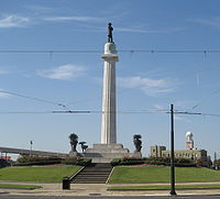
The area along the riverfront was part of the Old Warehouse District. The ward encompasses the upper portion of the New Orleans Central Business DistrictNew Orleans Central Business District
The Central Business District is a neighborhood of the city of New Orleans. A subdistrict of the French Quarter/CBD Area, its boundaries as defined by the City Planning Commission are: Iberville, Decatur and Canal Streets to the north, the Mississippi River to the east, the New Orleans Morial...
, including Lee Circle, as well as a sliver of the Lower Garden District. Further inland the Ward continues through part of the Central City
Central City, New Orleans
Central City is a neighborhood of the city of New Orleans. It is located at the lower end of Uptown, just above the New Orleans Central Business District, on the "lakeside" of St. Charles Avenue...
, including a number of housing projects.