Ab Kettleby
Encyclopedia
Ab Kettleby is a village and civil parish
within the Melton district of Leicestershire
, England
. It is 3 miles (4.8 km) north of Melton Mowbray
, along the A606 road, and has a population of 501.
Ab Kettleby is in north Leicestershire, not far from the town of Melton Mowbray
and three miles from the border with Nottinghamshire
. Situated 460 feet (140.2 m) above sea level it lies close to the neighbouring hamlets of Wartnaby and Holwell that form part of the civil parish of Ab Kettleby.
as Chetelbi, though a Roman
mosaic
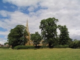
and pavement was found beneath the churchyard, indicating the antiquity of the village beyond 1086.. Unfortunately this previous building and a ditch running from north to south across the nave have caused serious structural problems for the church that require expensive attention. The church has a congregation that is determined to save this ancient church and is actively involved in the organisation of events to raise funds.
St. James Church has a Norman
font
, and a memorial
to Everard Digby
of the Gunpowder Plot
.
 The parish has a primary school, a public house named after Sugarloaf Mountain
, a community centre, a guest house, a 17th-century manor house, and medieval farmhouses and farm buildings. One of those farms was home to racehorse Desert Orchid
for several years.
It also has a village duck pond next to a large horse-chestnut tree and megalithic spring
. A public telephone box, once a common site throughout the UK but now a protected building, has been released to the protection of Ab Kettleby's council who are looking for ways to preserve and pay reverence to this icon of British life.
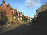
Also within the boundaries of this village is an Holy Well which is near the village pond, surrounded by orange-coloured ironstone cottages indicative of this area. According to Tony at Megalithic Portal . . . " Traditionally, it provided a good supply and never ran dry. After the construction of new houses nearby in 1992 the well dried up, but by 2001 was flowing copiously again. Unfortunately in 2001 an ugly metal grating was fitted that blocks all access to the water. The present well structure is a truncated pyramid just over a yard high and surmounted by what at first glance appears to be an upturned font but was probably a previous basin for the well."
Civil parish
In England, a civil parish is a territorial designation and, where they are found, the lowest tier of local government below districts and counties...
within the Melton district of Leicestershire
Leicestershire
Leicestershire is a landlocked county in the English Midlands. It takes its name from the heavily populated City of Leicester, traditionally its administrative centre, although the City of Leicester unitary authority is today administered separately from the rest of Leicestershire...
, England
England
England is a country that is part of the United Kingdom. It shares land borders with Scotland to the north and Wales to the west; the Irish Sea is to the north west, the Celtic Sea to the south west, with the North Sea to the east and the English Channel to the south separating it from continental...
. It is 3 miles (4.8 km) north of Melton Mowbray
Melton Mowbray
Melton Mowbray is a town in the Melton borough of Leicestershire, England. It is to the northeast of Leicester, and southeast of Nottingham...
, along the A606 road, and has a population of 501.
Ab Kettleby is in north Leicestershire, not far from the town of Melton Mowbray
Melton Mowbray
Melton Mowbray is a town in the Melton borough of Leicestershire, England. It is to the northeast of Leicester, and southeast of Nottingham...
and three miles from the border with Nottinghamshire
Nottinghamshire
Nottinghamshire is a county in the East Midlands of England, bordering South Yorkshire to the north-west, Lincolnshire to the east, Leicestershire to the south, and Derbyshire to the west...
. Situated 460 feet (140.2 m) above sea level it lies close to the neighbouring hamlets of Wartnaby and Holwell that form part of the civil parish of Ab Kettleby.
History
Ab Kettleby was first recorded in the Domesday BookDomesday Book
Domesday Book , now held at The National Archives, Kew, Richmond upon Thames in South West London, is the record of the great survey of much of England and parts of Wales completed in 1086...
as Chetelbi, though a Roman
Ancient Rome
Ancient Rome was a thriving civilization that grew on the Italian Peninsula as early as the 8th century BC. Located along the Mediterranean Sea and centered on the city of Rome, it expanded to one of the largest empires in the ancient world....
mosaic
Mosaic
Mosaic is the art of creating images with an assemblage of small pieces of colored glass, stone, or other materials. It may be a technique of decorative art, an aspect of interior decoration, or of cultural and spiritual significance as in a cathedral...
and pavement was found beneath the churchyard, indicating the antiquity of the village beyond 1086.. Unfortunately this previous building and a ditch running from north to south across the nave have caused serious structural problems for the church that require expensive attention. The church has a congregation that is determined to save this ancient church and is actively involved in the organisation of events to raise funds.
St. James Church has a Norman
Norman architecture
About|Romanesque architecture, primarily English|other buildings in Normandy|Architecture of Normandy.File:Durham Cathedral. Nave by James Valentine c.1890.jpg|thumb|200px|The nave of Durham Cathedral demonstrates the characteristic round arched style, though use of shallow pointed arches above the...
font
Baptismal font
A baptismal font is an article of church furniture or a fixture used for the baptism of children and adults.-Aspersion and affusion fonts:...
, and a memorial
Memorial
A memorial is an object which serves as a focus for memory of something, usually a person or an event. Popular forms of memorials include landmark objects or art objects such as sculptures, statues or fountains, and even entire parks....
to Everard Digby
Everard Digby
Sir Everard Digby was a member of the group of provincial English Catholics who planned the failed Gunpowder Plot of 1605. Although he was raised in a Protestant household, and married a Protestant, Digby and his wife were converted to Catholicism by the Jesuit priest John Gerard...
of the Gunpowder Plot
Gunpowder Plot
The Gunpowder Plot of 1605, in earlier centuries often called the Gunpowder Treason Plot or the Jesuit Treason, was a failed assassination attempt against King James I of England and VI of Scotland by a group of provincial English Catholics led by Robert Catesby.The plan was to blow up the House of...
.
Other

Sugarloaf Mountain, Brazil
Sugarloaf Mountain , is a peak situated in Rio de Janeiro, Brazil, at the mouth of Guanabara Bay on a peninsula that sticks out into the Atlantic Ocean...
, a community centre, a guest house, a 17th-century manor house, and medieval farmhouses and farm buildings. One of those farms was home to racehorse Desert Orchid
Desert Orchid
Desert Orchid , affectionately known as Dessie, was an English racehorse. The gallant grey achieved iconic status within National Hunt racing, where he was much loved by supporters for his front-running attacking style, iron will and extreme versatility. He was rated the fifth best National Hunt...
for several years.
It also has a village duck pond next to a large horse-chestnut tree and megalithic spring
Spring (hydrosphere)
A spring—also known as a rising or resurgence—is a component of the hydrosphere. Specifically, it is any natural situation where water flows to the surface of the earth from underground...
. A public telephone box, once a common site throughout the UK but now a protected building, has been released to the protection of Ab Kettleby's council who are looking for ways to preserve and pay reverence to this icon of British life.
Also within the boundaries of this village is an Holy Well which is near the village pond, surrounded by orange-coloured ironstone cottages indicative of this area. According to Tony at Megalithic Portal . . . " Traditionally, it provided a good supply and never ran dry. After the construction of new houses nearby in 1992 the well dried up, but by 2001 was flowing copiously again. Unfortunately in 2001 an ugly metal grating was fitted that blocks all access to the water. The present well structure is a truncated pyramid just over a yard high and surmounted by what at first glance appears to be an upturned font but was probably a previous basin for the well."

