
Accident, Maryland
Encyclopedia
Accident is a town in Garrett County
, Maryland
, United States
. The population was 353 at the 2000 census. The town is home to Northern Garrett High School. According to the book Labels for Locals by Paul Dickson
, a person from Accident is called an "Accidental".
was one of the early settlements in the far west of Maryland.
When Lord Baltimore opened up the area he called Monocacy Manor to settlement in the early 1770s,
Brooke Beall secured permission to survey 778 acres (3.1 km²). It will never be known for certain how Beall
came to choose this particular spot, but the surveyor was given clear instructions where to start.
He was to begin "in the center between two bounded white oak
trees, standing on the North Side of
the South fork of Bear Creek in or near a glade about one Hundred yards from said Run, about one
or two Miles above a Lick known by the name of the "Cole Mine Lick", about four miles (6 km) above
the mouth of Broad Creek and about one mile (1.6 km) East of a Ridge of the Negroe Mountain
." John Hanson
, Jr., later a delegate to the Continental Congress
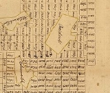
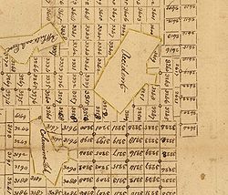
, and President of the United States in Congress Assembled, on April 14, 1774, surveyed the land, finding that it only contained 682 acres (2.8 km²). For the next twelve years nothing was done with the survey. Revolution intervened, and it was not until February 15, 1786, that the land was granted by means of a patent to William Deakins. The following year the surrounding countryside was surveyed into military lots by Francis Deakins, lots that were meant as compensation for the soldiers who served from Maryland during the War of independence. Each soldier who served for two years received one lot of 50 acres (202,343 m²), officers received four lots of 50 acres (202,343 m²) each.
 John Hanson, Jr's original certificate of survey is on line at the Maryland State Archives, among the surveys for Washington County
.
Kaese Mill
was listed on the National Register of Historic Places
in 1984. The James Drane House
was listed in 1985.
According to the United States Census Bureau
, the town has a total area of 0.5 square miles (1.3 km²), all of it land.
of 2000, there were 353 people, 138 households, and 96 families residing in the town. The population density
was 711.1 people per square mile (272.6/km²). There were 162 housing units at an average density of 326.3 per square mile (125.1/km²). The racial makeup of the town was:
There were 138 households out of which 37.7% had children under the age of 18 living with them, 54.3% were married couples
living together, 12.3% had a female householder with no husband present, and 30.4% were non-families. 28.3% of all households were made up of individuals and 21.7% had someone living alone who was 65 years of age or older. The average household size was 2.56 and the average family size was 3.14.
In the town the population was spread out with 29.2% under the age of 18, 7.1% from 18 to 24, 22.4% from 25 to 44, 18.4% from 45 to 64, and 22.9% who were 65 years of age or older. The median age was 38 years. For every 100 females there were 73.9 males. For every 100 females age 18 and over, there were 73.6 males.
The median income for a household in the town was $22,500, and the median income for a family was $40,556. Males had a median income of $25,250 versus $18,750 for females. The per capita income
for the town was $11,950. About 10.9% of families and 17.5% of the population were below the poverty line, including 17.3% of those under age 18 and 24.1% of those age 65 or over.
Garrett County, Maryland
Garrett County is the westernmost county of the U.S. state of Maryland. Created from Allegany County, Maryland in 1872 it was the last Maryland county to be formed. It was named for John Work Garrett , railroad executive, industrialist, and financier. Garrett served as president of the Baltimore...
, Maryland
Maryland
Maryland is a U.S. state located in the Mid Atlantic region of the United States, bordering Virginia, West Virginia, and the District of Columbia to its south and west; Pennsylvania to its north; and Delaware to its east...
, United States
United States
The United States of America is a federal constitutional republic comprising fifty states and a federal district...
. The population was 353 at the 2000 census. The town is home to Northern Garrett High School. According to the book Labels for Locals by Paul Dickson
Paul Dickson
For the football player of the same name see Paul Dickson .Paul Dickson is a freelance writer of more than 50 non-fiction books, mostly on American English language and popular culture. He has written many articles on a wide variety of subjects...
, a person from Accident is called an "Accidental".
History
Accident, Garrett County, MarylandGarrett County, Maryland
Garrett County is the westernmost county of the U.S. state of Maryland. Created from Allegany County, Maryland in 1872 it was the last Maryland county to be formed. It was named for John Work Garrett , railroad executive, industrialist, and financier. Garrett served as president of the Baltimore...
was one of the early settlements in the far west of Maryland.
When Lord Baltimore opened up the area he called Monocacy Manor to settlement in the early 1770s,
Brooke Beall secured permission to survey 778 acres (3.1 km²). It will never be known for certain how Beall
came to choose this particular spot, but the surveyor was given clear instructions where to start.
He was to begin "in the center between two bounded white oak
Oak
An oak is a tree or shrub in the genus Quercus , of which about 600 species exist. "Oak" may also appear in the names of species in related genera, notably Lithocarpus...
trees, standing on the North Side of
the South fork of Bear Creek in or near a glade about one Hundred yards from said Run, about one
or two Miles above a Lick known by the name of the "Cole Mine Lick", about four miles (6 km) above
the mouth of Broad Creek and about one mile (1.6 km) East of a Ridge of the Negroe Mountain
Negro Mountain
Negro Mountain is a long ridge of the Allegheny Mountains extending from Deep Creek Lake in Maryland, north to the Casselman River in Pennsylvania, USA. The summit, Mount Davis, is the highest point in Pennsylvania...
." John Hanson
John Hanson
John Hanson was a merchant and public official from Maryland during the era of the American Revolution. After serving in a variety of roles for the Patriot cause in Maryland, in 1779 Hanson was elected as a delegate to the Continental Congress...
, Jr., later a delegate to the Continental Congress
Continental Congress
The Continental Congress was a convention of delegates called together from the Thirteen Colonies that became the governing body of the United States during the American Revolution....
, and President of the United States in Congress Assembled, on April 14, 1774, surveyed the land, finding that it only contained 682 acres (2.8 km²). For the next twelve years nothing was done with the survey. Revolution intervened, and it was not until February 15, 1786, that the land was granted by means of a patent to William Deakins. The following year the surrounding countryside was surveyed into military lots by Francis Deakins, lots that were meant as compensation for the soldiers who served from Maryland during the War of independence. Each soldier who served for two years received one lot of 50 acres (202,343 m²), officers received four lots of 50 acres (202,343 m²) each.
Washington County, Maryland
Washington County is a county located in the western part of the U.S. state of Maryland, bordering southern Pennsylvania to the north, northern Virginia to the south, and the Eastern Panhandle of West Virginia to the south and west. As of the 2010 Census, its population is 147,430...
.
Kaese Mill
Kaese Mill
Kaese Mill is a historic grist mill located at Accident, Garrett County, Maryland, United States. It was constructed about 1868, and is a -story frame water-powered grist mill. It is the only fully operational water-powered grist mill in Maryland...
was listed on the National Register of Historic Places
National Register of Historic Places
The National Register of Historic Places is the United States government's official list of districts, sites, buildings, structures, and objects deemed worthy of preservation...
in 1984. The James Drane House
James Drane House
The James Drane House is a historic home located at Accident, Garrett County, Maryland, United States. It is a -story, long rectangular log and frame structure with a pitched gable roof, and an exterior stone chimney. A small cemetery about 100 yards to the north marks the site of Zion Lutheran...
was listed in 1985.
Geography
Accident is located at 39°37′41"N 79°19′12"W (39.628074, -79.319996).According to the United States Census Bureau
United States Census Bureau
The United States Census Bureau is the government agency that is responsible for the United States Census. It also gathers other national demographic and economic data...
, the town has a total area of 0.5 square miles (1.3 km²), all of it land.
Demographics
As of the censusCensus
A census is the procedure of systematically acquiring and recording information about the members of a given population. It is a regularly occurring and official count of a particular population. The term is used mostly in connection with national population and housing censuses; other common...
of 2000, there were 353 people, 138 households, and 96 families residing in the town. The population density
Population density
Population density is a measurement of population per unit area or unit volume. It is frequently applied to living organisms, and particularly to humans...
was 711.1 people per square mile (272.6/km²). There were 162 housing units at an average density of 326.3 per square mile (125.1/km²). The racial makeup of the town was:
- 99.72% White
- 0.28% from two or more races
- 0.00% African American
- 0.00% Native American
- 0.00% Asian
- 0.00% Pacific Islander
- 0.00% Other
- 0.00% Hispanic or Latino of any race
There were 138 households out of which 37.7% had children under the age of 18 living with them, 54.3% were married couples
Marriage
Marriage is a social union or legal contract between people that creates kinship. It is an institution in which interpersonal relationships, usually intimate and sexual, are acknowledged in a variety of ways, depending on the culture or subculture in which it is found...
living together, 12.3% had a female householder with no husband present, and 30.4% were non-families. 28.3% of all households were made up of individuals and 21.7% had someone living alone who was 65 years of age or older. The average household size was 2.56 and the average family size was 3.14.
In the town the population was spread out with 29.2% under the age of 18, 7.1% from 18 to 24, 22.4% from 25 to 44, 18.4% from 45 to 64, and 22.9% who were 65 years of age or older. The median age was 38 years. For every 100 females there were 73.9 males. For every 100 females age 18 and over, there were 73.6 males.
The median income for a household in the town was $22,500, and the median income for a family was $40,556. Males had a median income of $25,250 versus $18,750 for females. The per capita income
Per capita income
Per capita income or income per person is a measure of mean income within an economic aggregate, such as a country or city. It is calculated by taking a measure of all sources of income in the aggregate and dividing it by the total population...
for the town was $11,950. About 10.9% of families and 17.5% of the population were below the poverty line, including 17.3% of those under age 18 and 24.1% of those age 65 or over.
Notable Residents and Natives
- Wendell R. BeitzelWendell R. BeitzelWendell R. Beitzel was elected to the Maryland House of Delegates in 2006 to represent District 1A, which covers the western Maryland counties of Garrett and Alleganey County. He defeated Bill Aiken for the seat vacated by George C. Edwards, who ran for election as State Senator.-Education:Beitzel...
, member of Maryland House of DelegatesMaryland House of DelegatesThe Maryland House of Delegates is the lower house of the General Assembly, the state legislature of the U.S. state of Maryland, and is composed of 141 Delegates elected from 47 districts. The House chamber is located in the state capitol building on State Circle in Annapolis... - Darryl Glotfelty, member of the band The Lake Effect
- Elliot Glotfelty, member of the band The Lake Effect
- Rob Glotfelty, member of the band The Lake Effect
External links
- Maryland Municipal League: Accident
- Photographs of Accident Western Maryland History Online, Whilbr
- Ruth Enlow Library
- Map of Military Lots, Garrett County, Maryland, 1787 Western Maryland Regional Library.