

Adlingfleet
Encyclopedia
Adlingfleet is a village in the East Riding of Yorkshire
, England
, that forms part of the civil parish of Twin Rivers
. It is situated approximately 7 miles (11.3 km) to the east of Goole
town centre.
.
It was part of the Goole Rural District
in the West Riding of Yorkshire
from 1894 to 1974, and was then in the Boothferry district of Humberside
until 1996.
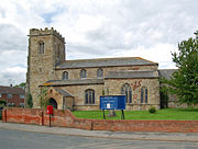 The parish church of All Saints is a Grade I listed building. The building has a cruciform plan, with a nave, a chancel, a south aisle, north and south transepts, and a square tower at the west end. Much of it is thirteenth century, with some re-used twelfth-century doors. The aisle and tower were built in the fifteenth century, and various amendments were made in 1792–94, in 1828 and in 1955–57. Internally, the building contains a number of monuments, including a very fine knight effigy to a member of the Haldenby family, who died in 1596.
joins the River Ouse
. In 1764, landowners contacted the civil engineer John Smeaton
, who drew up proposals for a drainage scheme. This formed the basis for an Act of Parliament
, which the landowners obtained in March 1767. The Act authorised Drainage Commissioners to be appointed, and they asked Smeaton's colleague, John Grundy, Jr.
, to act as engineer for the project. David Buffery was the resident engineer and Charles Tate the land surveyor. Grundy made few changes to Smeaton's plans. By July, he had drawn the plans and specifications for the sluice which would connect the main drain to the Trent, and work began on it in August. A contract for the excavation of the main drain was awarded to James Pinkerton and John Dyson in October. This was the first known civil engineering contract for both men, but they went on to work together on a number of schemes, including the Driffield Navigation
and the Laneham Drainage
project, and seem to have acted as management contractors, organising and supplying labour to these schemes. By April 1769, all the major elements of the project had been completed, and the project had cost around £7,000. The Commissioners retained Buffery, to ensure that some remaining minor works were completed to a satisfactory standard.
On 13 June 1903 the Commissioners asked J Simmons, an engineer from Doncaster, to estimate the cost of a pumping plant, which would be built at the head of the drain. He produced plans and drawings, liaising with suppliers to obtain costings for the pumps. The engine house would have been 18.5 by with a boiler house which was 11 feet (3.4 m) wide. He submitted the scheme to the Commissioners at a meeting in Goole on 30 June, but they decided that it was too costly, and so he produced a revised scheme, which included a 75 feet (22.9 m) chimney at the engine house. The cost was estimated at £1452, and another meeting at Goole on 15 July asked him to obtain formal tenders for the engine and pump house. However, the scheme was again considered to be too costly, and the Commissioners wrote to Simmons on 29 July to tell him that it had been cancelled. He invoiced them for 2.5 per cent of the estimate cost, plus travelling expenses, which amounted to £37 1s (£37.05). Following a half-yearly meeting on 10 May 1904, they wrote to say they were willing to pay 10 guineas (£10.50).
The previous sluice was 10 feet (3 m) wide, built of masonry, and was in an unstable condition by this time. The new one would be 16 feet (4.9 m) wide, with wing walls making the entire structure 61 feet (18.6 m) wide. It would be 105 feet (32 m) long, and the cill would be 22.5 feet (6.9 m) below the highest tide level. Construction would be of reinforced concrete, and the sluice would be built slightly to the north of the existing one, so that it could be completed without interrupting the discharge from the drain. Eleven quotations were received, and the contract was awarded to H. Arnold and Son of Doncaster on 15 February 1927, whose estimate was for £13,847. Having built the sluice structure, a new channel was excavated by mechanical excavator, to connect it to the existing drain. On the river side, the new channel was dredged by the Aire and Calder Navigation
Company and covered with stone. They had the necessary plant to complete this part of the work. The benefits were expounded by Simmons, the engineers for the work, in an article which appeared in The Concrete Way in 1929, where he stated that following the work, the water levels in winter were several inches below the normal summer levels. In August 1932 Simmons produced a specification for sluice doors to be installed at Willowbank bridge, but they were not installed.
Responsibility for the drain changed in 2005, when the Adlingfleet and Whitgift Drainage Commissioners amalgamated with five other Internal Drainage Board
s, to become part of the Isle of Axholme Internal Drainage Board. It changed again on 1 April 2011, when the new body amalgamated with three more Internal Drainage Boards to become the Isle of Axholme and North Nottinghamshire Water Level Management Board.
populations, and following new regulations introduced in 2009, a study was carried out to assess which catchments bordering the Humber
could provide suitable habitat for eels. Those with pumps were eliminated, but eight waterways were identified as possible candidates for the fitting of eel passes to aid eel migration. On Adlingfleet drain, the entrance sluice acted as a barrier, and there was a second barrier at the sluice and pumping station by Cowlane Bridge. Although rectification was deemed to be difficult, the drain was ranked fourth in a list of tributaries that could support the migration of eels and other migratory fish. By May 2011, an innovative fish-flap had been fitted, which does not compromise the flood protection, but allows fish to pass at certain states of the tide.
East Riding of Yorkshire
The East Riding of Yorkshire, or simply East Yorkshire, is a local government district with unitary authority status, and a ceremonial county of England. For ceremonial purposes the county also includes the city of Kingston upon Hull, which is a separate unitary authority...
, England
England
England is a country that is part of the United Kingdom. It shares land borders with Scotland to the north and Wales to the west; the Irish Sea is to the north west, the Celtic Sea to the south west, with the North Sea to the east and the English Channel to the south separating it from continental...
, that forms part of the civil parish of Twin Rivers
Twin Rivers, East Riding of Yorkshire
Twin Rivers is a civil parish in the East Riding of Yorkshire, England. It is situatedalong the south bank of the River Ouse to the east of the town of Goole, covering an area of ....
. It is situated approximately 7 miles (11.3 km) to the east of Goole
Goole
Goole is a town, civil parish and port located approximately inland on the confluence of the rivers Don and Ouse in the East Riding of Yorkshire, England...
town centre.
History
The village was known as Adelingesfluet in the Domesday BookDomesday Book
Domesday Book , now held at The National Archives, Kew, Richmond upon Thames in South West London, is the record of the great survey of much of England and parts of Wales completed in 1086...
.
It was part of the Goole Rural District
Goole Rural District
Goole was a rural district in the West Riding of Yorkshire, England from 1894 to 1974.It was created under the Local Government Act 1894, based on most of the Goole rural sanitary district . The town of Goole itself formed a separate urban district...
in the West Riding of Yorkshire
West Riding of Yorkshire
The West Riding of Yorkshire is one of the three historic subdivisions of Yorkshire, England. From 1889 to 1974 the administrative county, County of York, West Riding , was based closely on the historic boundaries...
from 1894 to 1974, and was then in the Boothferry district of Humberside
Humberside
Humberside was a non-metropolitan and ceremonial county in Northern England from 1 April 1974 until 1 April 1996. It was composed of land from either side of the Humber Estuary, created from portions of the East and West ridings of Yorkshire and parts of Lindsey, Lincolnshire...
until 1996.
Adlingfleet Drainage
Adlingfleet Level is an area of low-lying land covering around 5000 acres (2,023.4 ha), near where the River TrentRiver Trent
The River Trent is one of the major rivers of England. Its source is in Staffordshire on the southern edge of Biddulph Moor. It flows through the Midlands until it joins the River Ouse at Trent Falls to form the Humber Estuary, which empties into the North Sea below Hull and Immingham.The Trent...
joins the River Ouse
River Ouse, Yorkshire
The River Ouse is a river in North Yorkshire, England. The river is formed from the River Ure at Cuddy Shaw Reach near Linton-on-Ouse, about 6 miles downstream of the confluence of the River Swale with the River Ure...
. In 1764, landowners contacted the civil engineer John Smeaton
John Smeaton
John Smeaton, FRS, was an English civil engineer responsible for the design of bridges, canals, harbours and lighthouses. He was also a capable mechanical engineer and an eminent physicist...
, who drew up proposals for a drainage scheme. This formed the basis for an Act of Parliament
Act of Parliament
An Act of Parliament is a statute enacted as primary legislation by a national or sub-national parliament. In the Republic of Ireland the term Act of the Oireachtas is used, and in the United States the term Act of Congress is used.In Commonwealth countries, the term is used both in a narrow...
, which the landowners obtained in March 1767. The Act authorised Drainage Commissioners to be appointed, and they asked Smeaton's colleague, John Grundy, Jr.
John Grundy, Jr.
John Grundy, Jr. was an English civil engineer, who worked on a number of drainage schemes, canal projects and dock works. He lived in Spalding, Lincolnshire from 1739...
, to act as engineer for the project. David Buffery was the resident engineer and Charles Tate the land surveyor. Grundy made few changes to Smeaton's plans. By July, he had drawn the plans and specifications for the sluice which would connect the main drain to the Trent, and work began on it in August. A contract for the excavation of the main drain was awarded to James Pinkerton and John Dyson in October. This was the first known civil engineering contract for both men, but they went on to work together on a number of schemes, including the Driffield Navigation
Driffield Navigation
The Driffield Navigation is an waterway, through the heart of the Holderness Plain to the market town of Driffield, East Riding of Yorkshire, England. The northern section of it is a canal, and the southern section is part of the River Hull. Construction was authorised in 1767, and it was fully...
and the Laneham Drainage
Laneham
Laneham is a small Nottinghamshire village on the banks of the River Trent. It is due west of the city of Lincoln and east of the market town of Retford.-Geography:...
project, and seem to have acted as management contractors, organising and supplying labour to these schemes. By April 1769, all the major elements of the project had been completed, and the project had cost around £7,000. The Commissioners retained Buffery, to ensure that some remaining minor works were completed to a satisfactory standard.
On 13 June 1903 the Commissioners asked J Simmons, an engineer from Doncaster, to estimate the cost of a pumping plant, which would be built at the head of the drain. He produced plans and drawings, liaising with suppliers to obtain costings for the pumps. The engine house would have been 18.5 by with a boiler house which was 11 feet (3.4 m) wide. He submitted the scheme to the Commissioners at a meeting in Goole on 30 June, but they decided that it was too costly, and so he produced a revised scheme, which included a 75 feet (22.9 m) chimney at the engine house. The cost was estimated at £1452, and another meeting at Goole on 15 July asked him to obtain formal tenders for the engine and pump house. However, the scheme was again considered to be too costly, and the Commissioners wrote to Simmons on 29 July to tell him that it had been cancelled. He invoiced them for 2.5 per cent of the estimate cost, plus travelling expenses, which amounted to £37 1s (£37.05). Following a half-yearly meeting on 10 May 1904, they wrote to say they were willing to pay 10 guineas (£10.50).
1927 Upgrade
After periodic flooding in the 1920s, a survey was made, indicating that the fall on the main drain was around 2 inches per mile (30 mm per km), which was not sufficient for good drainage by gravity. Based on the premise that a pumping scheme had an annual cost for running and maintenance, whereas lowering the cill was essentially a one-time cost, the Commissioners of the Adlingfleet and Whitgift Drainage Board asked for tenders for a new sluice in December 1926. The cill would be 2.5 foot (0.762 m) lower than the existing one, and the contract was for construction of the sluice and work on the drain itself, to make it wider and deeper. Near the sluice, the channel would be 75 feet (22.9 m) wide at the top, 12 feet (3.7 m) wide at the bottom and 20.5 feet (6.2 m) deep. Decreasing sizes were specified for six sections over its 4 miles (6.4 km) length, with the final section being 10 feet (3 m) wide at the bottom and only 1.83 foot (0.557784 m) deep. Various bridges would need their foundations lowered and other improvements to be made, while Gill's Close bridge was to be dismantled and not replaced.The previous sluice was 10 feet (3 m) wide, built of masonry, and was in an unstable condition by this time. The new one would be 16 feet (4.9 m) wide, with wing walls making the entire structure 61 feet (18.6 m) wide. It would be 105 feet (32 m) long, and the cill would be 22.5 feet (6.9 m) below the highest tide level. Construction would be of reinforced concrete, and the sluice would be built slightly to the north of the existing one, so that it could be completed without interrupting the discharge from the drain. Eleven quotations were received, and the contract was awarded to H. Arnold and Son of Doncaster on 15 February 1927, whose estimate was for £13,847. Having built the sluice structure, a new channel was excavated by mechanical excavator, to connect it to the existing drain. On the river side, the new channel was dredged by the Aire and Calder Navigation
Aire and Calder Navigation
The Aire and Calder Navigation is a river and canal system of the River Aire and the River Calder in the metropolitan county of West Yorkshire, England. The first improvements to the rivers above Knottingley were completed in 1704 when the Aire was made navigable to Leeds and the Calder to...
Company and covered with stone. They had the necessary plant to complete this part of the work. The benefits were expounded by Simmons, the engineers for the work, in an article which appeared in The Concrete Way in 1929, where he stated that following the work, the water levels in winter were several inches below the normal summer levels. In August 1932 Simmons produced a specification for sluice doors to be installed at Willowbank bridge, but they were not installed.
Current state
A sluice with pumps was eventually built to the north of Cowlane bridge in Adlingfleet. The control building carries the date 1984 on a large stone built into the walls. Construction of a sewage treatment works next to the sluice was well advanced in 2011. The bridges at Hoggards Lane, Cowlane and Willowbank have been replaced by corrugated steel tubes, backfilled up to the level of the road surface. Mains bridge is still a single arched brick structure, while at the end of the drain, Whinsgate bridge consists of the main brick arch under the A161 road, with arches in both wing walls, which enable tracks to cross Dodds Dyke and Eastoft Drain. At the outfall, the pointed gates have gone, replaced by a circular opening through a massed concrete infill, with a flap gate on the outlet side, and a vertical lifting steel gate on the inland side.Responsibility for the drain changed in 2005, when the Adlingfleet and Whitgift Drainage Commissioners amalgamated with five other Internal Drainage Board
Internal Drainage Board
An internal drainage board is a type of operating authority which is established in areas of special drainage need in England and Wales with permissive powers to undertake work to secure clean water drainage and water level management within drainage districts...
s, to become part of the Isle of Axholme Internal Drainage Board. It changed again on 1 April 2011, when the new body amalgamated with three more Internal Drainage Boards to become the Isle of Axholme and North Nottinghamshire Water Level Management Board.
Eels
The presence of barriers across waterways has been identified as one of the factors behind the decline in eelEel
Eels are an order of fish, which consists of four suborders, 20 families, 111 genera and approximately 800 species. Most eels are predators...
populations, and following new regulations introduced in 2009, a study was carried out to assess which catchments bordering the Humber
Humber
The Humber is a large tidal estuary on the east coast of Northern England. It is formed at Trent Falls, Faxfleet, by the confluence of the tidal River Ouse and the tidal River Trent. From here to the North Sea, it forms part of the boundary between the East Riding of Yorkshire on the north bank...
could provide suitable habitat for eels. Those with pumps were eliminated, but eight waterways were identified as possible candidates for the fitting of eel passes to aid eel migration. On Adlingfleet drain, the entrance sluice acted as a barrier, and there was a second barrier at the sluice and pumping station by Cowlane Bridge. Although rectification was deemed to be difficult, the drain was ranked fourth in a list of tributaries that could support the migration of eels and other migratory fish. By May 2011, an innovative fish-flap had been fitted, which does not compromise the flood protection, but allows fish to pass at certain states of the tide.