Agua Fria River (Arizona)
Encyclopedia


Prescott, Arizona
Prescott is a city in Yavapai County, Arizona, USA. It was designated "Arizona's Christmas City" by Arizona Governor Rose Mofford in the late 1980s....
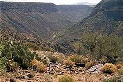
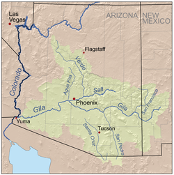
, USA. Prescott draws much of its municipal water supply from the upper Agua Fria drainage. The Agua Fria runs through the Agua Fria National Monument
Agua Fria National Monument
Agua Fria National Monument is located in the U.S. state of Arizona, approximately 40 miles north of downtown Phoenix, Arizona. Created by Presidential proclamation on January 11, 2000, the 71,100 acre monument is managed by the U.S. Bureau of Land Management, an agency within the U.S....
. The river then flows through a small canyon called "Black Canyon" into Lake Pleasant
Lake Pleasant Regional Park
Lake Pleasant Regional Park is a large outdoors recreation area straddling the Maricopa and Yavapai county border northwest of Phoenix, Arizona...
, a popular recreation area near Peoria, Arizona
Peoria, Arizona
Peoria is a city in Maricopa and Yavapai counties in the U.S. state of Arizona. Located primarily in Maricopa County, it is a major suburb of Phoenix. According to 2010 Census Bureau releases, the population of the city is 154,065. Peoria is currently the sixth largest city in Arizona for land...
.
(There is a large "Black Canyon
Black Canyon of the Colorado
The Black Canyon of the Colorado is the canyon on the Colorado River where Hoover Dam was built. The canyon is located on the Colorado River at the state line between Nevada and Arizona. The western wall of the gorge is in the El Dorado Mountains, and the eastern wall is in the Black Mountains of...
" on the Colorado River along the Arizona
Arizona
Arizona ; is a state located in the southwestern region of the United States. It is also part of the western United States and the mountain west. The capital and largest city is Phoenix...
-Nevada
Nevada
Nevada is a state in the western, mountain west, and southwestern regions of the United States. With an area of and a population of about 2.7 million, it is the 7th-largest and 35th-most populous state. Over two-thirds of Nevada's people live in the Las Vegas metropolitan area, which contains its...
border.)
During rainy times when water flows in the intermittent Agua Fria River, it discharges into the Gila River
Gila River
The Gila River is a tributary of the Colorado River, 650 miles long, in the southwestern states of New Mexico and Arizona.-Description:...
, which is also a river that only flows during wet periods of the year.
The Central Arizona Water Conservation District of the Central Arizona Project operates the Agua Fria Recharge Project, which is located about four miles south of the New Waddell Dam
New Waddell Dam
The New Waddell Dam is an embankment dam on the Agua Fria River in Maricopa County, Arizona, northwest of Phoenix. It serves as part of the Central Arizona Project while also providing water for the Maricopa Water District. The dam creates Lake Pleasant with water from the Agua Fria and also the...
. It serves to recharge underground aquifers in this area.

