Aigosthena
Encyclopedia
Aigosthena also Egosthena, was an ancient Greek
fortified city of Attica
19 km (12 mi) NW of the ancient city of Megara
to which it belonged. The fortified port was built in a forested, hilly area beside the coast of the Gulf of Corinth
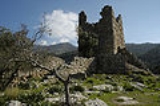
. The walls of the ancient city are preserved to significant height around the citadel and along the northern wall. The citadel retains several of the tallest surviving towers of ancient Greece. The site is located in the surrounding village of Porto Germeno (which is also known by the name Aigosthena) and overlooks the Gulf of Corinth
as well as the Alkyonides Gulf
.It is part of the municipality of Vilia
and is historically the northernmost city of the Megaris
(Megarida).There is a small bay located to the west named Aigosthena Bay. The site is 48 km (30 mi) NW of Athens
. Aigosthena is linked by road to Vilia
and the GR-3
(Athens - Thiva) and south to Schinos Beach and to Megara
.
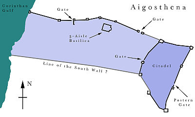
 The ancient site of Aigosthena consisted of a fortified citadel connected to the sea by two fortification walls. Measuring roughly 90 by 187m (~575 Doric feet), the citadel was roughly trapezoidal in plan, with the narrower side (113m) facing west toward the sea. The citadel was constructed along the contours of a 55m hill, and was defended by eight artillery towers incorporated into its perimeter wall. There was a primary gate on the west side into the area between the north and south walls to the sea. A small postern (auxiliary) gate was located immediately north of the second tower on the eastern side. The northern of the two walls to the sea is well-preserved, stretching 370m to a final tower of which the foundations and fallen blocks are now underwater. The northern wall consisted of six towers and a fortified gate running in a nearly strait line from the northwest corner of the citadel to the sea. The bed of a river runs along the probably line of the south wall, which is not evident.
The walls were built in a variety of masonry styles, which may be evidence of different phases of construction. Masonry styles in use include isodomic (aslars with hammered faces and drafted corners), pseudo-isodomic, and - in sections – a style approaching polygonal. In general terms, these walls are among the best preserved of any of the Hellenistic period and show a high level of skill and finish. There is clear evidence of quarrying immediately south of the southeast tower of the citadel.
Based on the design of the defense towers, Ober proposes that the site was fortified after 370 BCE. Lawrence opts for a date in the late 4th century BCE, on the assumption that Demetrios Poliorcetes
built the fortress rather than simply occupying it. The site was under the control of the Achaean League
in 243-224 BCE, and in 224 - 146 BCE it joined the Boeotian League. Shrines of Melampos
and Heracles are known to have existed by inscriptions recovered on the site. The town and its warehouses operated down into Roman times. An inscription of c. 420 CE listed Aigosthena as a free city. A five-aisled Christian basilica was erected in the lower fortified area in the medieval period, and there was a monastery complex within the citadel.
Ancient Greece
Ancient Greece is a civilization belonging to a period of Greek history that lasted from the Archaic period of the 8th to 6th centuries BC to the end of antiquity. Immediately following this period was the beginning of the Early Middle Ages and the Byzantine era. Included in Ancient Greece is the...
fortified city of Attica
Attica
Attica is a historical region of Greece, containing Athens, the current capital of Greece. The historical region is centered on the Attic peninsula, which projects into the Aegean Sea...
19 km (12 mi) NW of the ancient city of Megara
Megara
Megara is an ancient city in Attica, Greece. It lies in the northern section of the Isthmus of Corinth opposite the island of Salamis, which belonged to Megara in archaic times, before being taken by Athens. Megara was one of the four districts of Attica, embodied in the four mythic sons of King...
to which it belonged. The fortified port was built in a forested, hilly area beside the coast of the Gulf of Corinth
Gulf of Corinth
The Gulf of Corinth or the Corinthian Gulf is a deep inlet of the Ionian Sea separating the Peloponnese from western mainland Greece...
. The walls of the ancient city are preserved to significant height around the citadel and along the northern wall. The citadel retains several of the tallest surviving towers of ancient Greece. The site is located in the surrounding village of Porto Germeno (which is also known by the name Aigosthena) and overlooks the Gulf of Corinth
Gulf of Corinth
The Gulf of Corinth or the Corinthian Gulf is a deep inlet of the Ionian Sea separating the Peloponnese from western mainland Greece...
as well as the Alkyonides Gulf
Alkyonides Gulf
The Alkyonides Gulf , also Alkionides Gulf is a strait that connects with the Gulf of Corinth to the west. The strait is approximately 20 to 25 km long and 20 km wide. It stretches from Aigosthena to Cape Trachilos from east to west and from Mikra Strava to Cape Trachilos from north to...
.It is part of the municipality of Vilia
Vilia
Vilia is a village and a former municipality of West Attica, Greece. Since the 2011 local government reform it is part of the municipality Mandra-Eidyllia, of which it is a municipal unit....
and is historically the northernmost city of the Megaris
Megaris
This is also the ancient Greek name of a small island off Naples, site of the Castel dell'Ovo.Megaris or the Megarid was a small but populous state of ancient Greece, west of Attica and north of Corinthia, whose inhabitants were adventurous seafarers, credited with deceitful propensities...
(Megarida).There is a small bay located to the west named Aigosthena Bay. The site is 48 km (30 mi) NW of Athens
Athens
Athens , is the capital and largest city of Greece. Athens dominates the Attica region and is one of the world's oldest cities, as its recorded history spans around 3,400 years. Classical Athens was a powerful city-state...
. Aigosthena is linked by road to Vilia
Vilia
Vilia is a village and a former municipality of West Attica, Greece. Since the 2011 local government reform it is part of the municipality Mandra-Eidyllia, of which it is a municipal unit....
and the GR-3
Greek National Road 3
Greek National Road 3 begins from Eleusis and heads north, passing Larissa, Florina and terminates at the border with the Republic of Macedonia in Niki, which from there links with the M3. The road is part of the E65. In the late 1980s, motorway bypasses have been constructed for the towns...
(Athens - Thiva) and south to Schinos Beach and to Megara
Megara
Megara is an ancient city in Attica, Greece. It lies in the northern section of the Isthmus of Corinth opposite the island of Salamis, which belonged to Megara in archaic times, before being taken by Athens. Megara was one of the four districts of Attica, embodied in the four mythic sons of King...
.
Ancient Aigosthena

The walls were built in a variety of masonry styles, which may be evidence of different phases of construction. Masonry styles in use include isodomic (aslars with hammered faces and drafted corners), pseudo-isodomic, and - in sections – a style approaching polygonal. In general terms, these walls are among the best preserved of any of the Hellenistic period and show a high level of skill and finish. There is clear evidence of quarrying immediately south of the southeast tower of the citadel.
Based on the design of the defense towers, Ober proposes that the site was fortified after 370 BCE. Lawrence opts for a date in the late 4th century BCE, on the assumption that Demetrios Poliorcetes
Demetrius I of Macedon
Demetrius I , called Poliorcetes , son of Antigonus I Monophthalmus and Stratonice, was a king of Macedon...
built the fortress rather than simply occupying it. The site was under the control of the Achaean League
Achaean League
The Achaean League was a Hellenistic era confederation of Greek city states on the northern and central Peloponnese, which existed between 280 BC and 146 BC...
in 243-224 BCE, and in 224 - 146 BCE it joined the Boeotian League. Shrines of Melampos
Melampus
In Greek mythology, Melampus, or Melampous , was a legendary soothsayer and healer, originally of Pylos, who ruled at Argos. He was the introducer of the worship of Dionysus, according to Herodotus, who asserted that his powers as a seer were derived from the Egyptians and that he could understand...
and Heracles are known to have existed by inscriptions recovered on the site. The town and its warehouses operated down into Roman times. An inscription of c. 420 CE listed Aigosthena as a free city. A five-aisled Christian basilica was erected in the lower fortified area in the medieval period, and there was a monastery complex within the citadel.
Ancient sources
- I.G. 7.1; 7.213; 7.43
- XenophonXenophonXenophon , son of Gryllus, of the deme Erchia of Athens, also known as Xenophon of Athens, was a Greek historian, soldier, mercenary, philosopher and a contemporary and admirer of Socrates...
, Hellenica - 5.4.18; 6.4.26 - Pliny the elderPliny the ElderGaius Plinius Secundus , better known as Pliny the Elder, was a Roman author, naturalist, and natural philosopher, as well as naval and army commander of the early Roman Empire, and personal friend of the emperor Vespasian...
, Natural History – 4.23
External links
- http://www.missouri.edu/~daw262/aigos.html
- Aigosthena — a clip from Menoume Ellada — ERT Online
- Egosthena on GTP Travel Pages (in English and Greek)

