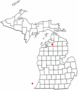
Alba, Michigan
Encyclopedia

Antrim County, Michigan
-History:Antrim County was formed in 1863. In 1950 its population was 10,721. The county seat was originally located in Elk Rapids, but was moved to Bellaire in 1904 after 25 years of litigation.-Demographics:...
in the U.S. state
U.S. state
A U.S. state is any one of the 50 federated states of the United States of America that share sovereignty with the federal government. Because of this shared sovereignty, an American is a citizen both of the federal entity and of his or her state of domicile. Four states use the official title of...
of Michigan
Michigan
Michigan is a U.S. state located in the Great Lakes Region of the United States of America. The name Michigan is the French form of the Ojibwa word mishigamaa, meaning "large water" or "large lake"....
. It is situated on U.S. Highway 131 just north of Mancelona
Mancelona, Michigan
Mancelona is a village in Antrim County in the U.S. state of Michigan. The population was 1,408 at the 2000 census. The village is located within Mancelona Township.-History:...
. Half of the community is in Star Township
Star Township, Michigan
Star Township is a civil township of Antrim County in the U.S. state of Michigan. The population was 745 at the 2000 census.-Geography:According to the United States Census Bureau, the township has a total area of , of which, of it is land and of it is water.-Demographics:As of the census of...
and half is in Chestonia Township
Chestonia Township, Michigan
Chestonia Township is a civil township of Antrim County in the U.S. state of Michigan. The population was 546 at the 2000 census. From the 1901 to 1932, the junction of the East Jordan and Southern and the Detroit and Charlevoix railroads lied within the township.-Geography:According to the United...
. In the 1900's, it was the site of the Detroit and Charlevoix and Grand Rapids and Indiana
Grand Rapids and Indiana Railroad
The Grand Rapids and Indiana Railroad at its height provided passenger and freight railroad services between Cincinnati, Ohio and the Straits of Mackinac in Michigan, USA...
railroad junction.
Alba was established in 1876.
Geography
Alba is at 44°58′29"N 84°58′07"W and the FIPS place code is 00900. The elevation is 1179 feet above sea levelSea level
Mean sea level is a measure of the average height of the ocean's surface ; used as a standard in reckoning land elevation...
. The Alba ZIP code
ZIP Code
ZIP codes are a system of postal codes used by the United States Postal Service since 1963. The term ZIP, an acronym for Zone Improvement Plan, is properly written in capital letters and was chosen to suggest that the mail travels more efficiently, and therefore more quickly, when senders use the...
49611 provides P.O. Box only service for an area around the community.

