Alyth
Encyclopedia

Perth and Kinross
Perth and Kinross is one of 32 council areas in Scotland, and a Lieutenancy Area. It borders onto the Aberdeenshire, Angus, Dundee City, Fife, Clackmannanshire, Stirling, Argyll and Bute and Highland council areas. Perth is the administrative centre...
, Scotland
Scotland
Scotland is a country that is part of the United Kingdom. Occupying the northern third of the island of Great Britain, it shares a border with England to the south and is bounded by the North Sea to the east, the Atlantic Ocean to the north and west, and the North Channel and Irish Sea to the...
, situated under the Hill of Alyth five miles northeast of Blairgowrie
Blairgowrie and Rattray
Blairgowrie and Rattray and Raitear is possibly from an English language cognate of Gaelic ràth, meaning fortress + a Pictish term cognate with Welsh tref, meaning settlement) is a twin burgh in Perth and Kinross, Scotland. Amongst locals, the town is colloquially known simply as "Blair"...
. The village has a population of 2,301 . It has a primary school and did have a high school up to fourth year until 1994, when it was closed and all pupils removed to Blairgowrie for high school or Webster's High School situated in nearby Kirriemuir
Kirriemuir
Kirriemuir, sometimes called Kirrie, is a burgh in Angus, Scotland.-History:The history of Kirriemuir extends to the early historical period and it appears to have been a centre of some ecclesiastical importance...
.
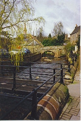
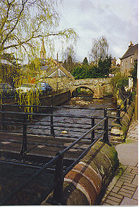
Alyth is located on a burn which bears its name and owes its position to a confluence of drovers' roads used by hill farmers to bring their sheep down to market. A picturesque 17th century pack-horse bridge is among a number of stone bridges crossing the burn in the village (see photo). The ruins
Ruins
Ruins are the remains of human-made architecture: structures that were once complete, as time went by, have fallen into a state of partial or complete disrepair, due to lack of maintenance or deliberate acts of destruction...
of the old church, known locally as The Arches, stand in a graveyard in a prominent position at the top of the town. The current church building, completed in 1839 to the design of Edinburgh
Edinburgh
Edinburgh is the capital city of Scotland, the second largest city in Scotland, and the eighth most populous in the United Kingdom. The City of Edinburgh Council governs one of Scotland's 32 local government council areas. The council area includes urban Edinburgh and a rural area...
architect, Thomas Hamilton, dominates the skyline of the town. It is Gothic
Gothic Revival architecture
The Gothic Revival is an architectural movement that began in the 1740s in England...
in style, with Romanesque
Romanesque architecture
Romanesque architecture is an architectural style of Medieval Europe characterised by semi-circular arches. There is no consensus for the beginning date of the Romanesque architecture, with proposals ranging from the 6th to the 10th century. It developed in the 12th century into the Gothic style,...
influences, especially in the windows, and has an unusually high spire. Inside the church is to be found the funeral escutcheon of Sir George Ramsay, sixth baronet of Bamff, who was killed in a duel
Duel
A duel is an arranged engagement in combat between two individuals, with matched weapons in accordance with agreed-upon rules.Duels in this form were chiefly practised in Early Modern Europe, with precedents in the medieval code of chivalry, and continued into the modern period especially among...
at Musselburgh
Musselburgh
Musselburgh is the largest settlement in East Lothian, Scotland, on the coast of the Firth of Forth, six miles east of Edinburgh city centre.-History:...
, in April 1790 - one of the last duelling deaths in Scotland. In the church porch is preserved a late 7th-early 8th century Pictish cross-slab, with a decorated cross on one face and a single Pictish symbol ('double disc and Z-rod') on the other. It was discovered in Alyth in 1887 when ground was being levelled in front of the manse
Manse
A manse is a house inhabited by, or formerly inhabited by, a minister, usually used in the context of a Presbyterian, Methodist, Baptist or United Church...
.
History and Archaeology
To the northeast of the town a hill-fort, possibly of Pictish date, stands atop Barry (or 'barrow') Hill. The remains consist of massive collapsed stone ramparts that take advantage of the topography of the Hill. Local legend connects the fort with King ArthurKing Arthur
King Arthur is a legendary British leader of the late 5th and early 6th centuries, who, according to Medieval histories and romances, led the defence of Britain against Saxon invaders in the early 6th century. The details of Arthur's story are mainly composed of folklore and literary invention, and...
, and it is claimed that Guinevere
Guinevere
Guinevere was the legendary queen consort of King Arthur. In tales and folklore, she was said to have had a love affair with Arthur's chief knight Sir Lancelot...
, Arthur's queen, was imprisoned here for a short time.
Another nearby early medieval feature is a Pictish 'Class I' symbol stone in a field on Bruceton Farm somewhat to the east of Alyth. This slab is one of relatively few likely still to be in its original position. It may have marked an ancient burial.
There may have been a Christian presence in this area from early times, since the medieval parish church was dedicated to St. Moluag of Lismore
Lismore, Scotland
Lismore is a partially Gaelic speaking island in the Inner Hebrides of Scotland. This fertile, low-lying island was once a major centre of Celtic Christianity, with a monastery founded by Saint Moluag and the seat of the Bishop of Argyll.-Geography:...
(d. 592), a contemporary of St. Columba. The cross-slab mentioned above also suggests this.
Alyth was granted a Charter by James III
James III of Scotland
James III was King of Scots from 1460 to 1488. James was an unpopular and ineffective monarch owing to an unwillingness to administer justice fairly, a policy of pursuing alliance with the Kingdom of England, and a disastrous relationship with nearly all his extended family.His reputation as the...
in 1488, raising Alyth to the rank of Burgh of Barony
Burgh of barony
A burgh of barony is a type of Scottish town .They were distinct from royal burghs as the title was granted to a tenant-in-chief, a landowner who held his estates directly from the crown....
with the right to hold markets and fairs.


- Archaeological Excavation of a souterrainSouterrainSouterrain is a name given by archaeologists to a type of underground structure associated mainly with the Atlantic Iron Age. These structures appear to have been brought northwards from Gaul during the late Iron Age. Regional names include earth houses, fogous and Pictish houses...
- Shanzie Farm
A late British Iron Age
Iron Age
The Iron Age is the archaeological period generally occurring after the Bronze Age, marked by the prevalent use of iron. The early period of the age is characterized by the widespread use of iron or steel. The adoption of such material coincided with other changes in society, including differing...
souterrain
Souterrain
Souterrain is a name given by archaeologists to a type of underground structure associated mainly with the Atlantic Iron Age. These structures appear to have been brought northwards from Gaul during the late Iron Age. Regional names include earth houses, fogous and Pictish houses...
was excavated by a team of Headland Archaeology
Headland Archaeology
Headland Archaeology comprises a holding company Headland Group Ltd and the trading subsidiaries Headland Archaeology Ltd, Headland Archaeology Ltd and Archaeological Investigations Ltd....
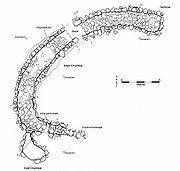
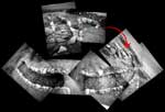
in Shanzie Farm, c 3.5. north-east of Alyth. The underground structure was roughly C-shaped in plan and measured c 35 metres in length. There was a single chamber c 5m long and an entrance to the south-east. For the most part, the souterrain had been badly plough truncated and the walls survived as a single course. The northern terminal of the souterrain was better preserved, where 3-4 courses of wall survive. The chamber here narrowed and had been filled with rubble to a depth. The walls also started to corbell inwards indicating this was originally a stone-capped structure rather than timber roofed. No evidence of associated settlement or any other surface features were identified; these have undoubtedly been lost to the plough. The structure is typical of the 'southern Pictland group'
The souterrain had clearly been broken into during the Victorian period, but also, during medieval times. Finds included several types of late prehistoric
Prehistoric Scotland
Archaeology and geology continue to reveal the secrets of prehistoric Scotland, uncovering a complex and dramatic past before the Romans brought Scotland into the scope of recorded history...
pottery, a fragment of probable Roman pottery, an amber ring, a pair of tweezers, a brooch or clasp, two copper alloy rings and a fragment from a quern stone. The souterrain was partially backfilled allowing visitors to see the structure in plan.
The arches are no longer open to the public now. Unfortunately they are not safe.
Culture
A golf club was established in Alyth in 1894. The original nine hole course was designed by the Old Tom Morris of St. Andrews and was later modified and extended to 18 holes by James Braid (1934). A further two clubs have opened since then, the Strathmore Golf Centre (1986) with an 18 and a 9 hole course and the Glenisla Club (1992).The town has a small local museum, open in summer, which is run by Perth
Perth, Scotland
Perth is a town and former city and royal burgh in central Scotland. Located on the banks of the River Tay, it is the administrative centre of Perth and Kinross council area and the historic county town of Perthshire...
Museum. This has access to the arches, the oldest buildings in Alyth.

