Amphoe Than To
Encyclopedia
Than To is a district (Amphoe
) in the southern part of Yala Province
, southern Thailand
.
on June 9 1975 and formed the new minor district (King Amphoe) Than To. It was upgraded to a full district on July 13 1981.
The area had been the location of the Than To prison of the Corrections department. The prison was established in 1935 for the political prisoners. It was closed in 1957. Later the government converted the area to Than To estate.
of Yala province, Si Sakhon
of Narathiwat Province
, Betong
of Yala province again and the state Kedah
of Malaysia.
), which are further subdivided into 33 villages (muban
). The township (thesaban tambon) of Khok Chang covers parts of the tambon Mae Wat.
Amphoe
An amphoe is the second level administrative subdivision of Thailand. Usually translated as district, amphoe make up the provinces, and are analogous to a county seat...
) in the southern part of Yala Province
Yala Province
Yala is the southernmost province of Thailand. Neighboring provinces are Songkhla, Pattani and Narathiwat. Yala is the only land-locked province in the south of Thailand...
, southern Thailand
Thailand
Thailand , officially the Kingdom of Thailand , formerly known as Siam , is a country located at the centre of the Indochina peninsula and Southeast Asia. It is bordered to the north by Burma and Laos, to the east by Laos and Cambodia, to the south by the Gulf of Thailand and Malaysia, and to the...
.
History
The tambon Mae Wat was separated from Bannang Sata districtAmphoe Bannang Sata
Bannang Sata is a district in the southern part of Yala Province, southern Thailand.-History:The name Bannang Sata is actually the Thai corruption of Benang Setar , its original Malay name...
on June 9 1975 and formed the new minor district (King Amphoe) Than To. It was upgraded to a full district on July 13 1981.
The area had been the location of the Than To prison of the Corrections department. The prison was established in 1935 for the political prisoners. It was closed in 1957. Later the government converted the area to Than To estate.
Geography
Neighboring districts are (from the north clockwise) Bannang SataAmphoe Bannang Sata
Bannang Sata is a district in the southern part of Yala Province, southern Thailand.-History:The name Bannang Sata is actually the Thai corruption of Benang Setar , its original Malay name...
of Yala province, Si Sakhon
Amphoe Si Sakhon
-History:Originally Tambon Sa Ko was a part of the Rueso district, but the development division of the Thai military settled in the area from 1963–1974, thus developing the infrastructure of Tambon Sa Ko. The interior ministry subsequently created Si Sakhon minor district consisting of the two...
of Narathiwat Province
Narathiwat Province
Narathiwat is one of the southern provinces of Thailand. Neighboring provinces are Yala and Pattani. To the south it borders the Malaysian state of Kelantan. The southern railway line ends in this province that is one of the nation’s five provinces that borders Malaysia. The name of this...
, Betong
Amphoe Betong
Betong is the southernmost district of Yala Province, southern Thailand.-Geography:Betong is located at the boundary to Malaysia. To the north is Than To, to the east Chanae . To the south is the Malayian state of Perak, to the west Kedah.-History:In the past time, this area was under Mueang...
of Yala province again and the state Kedah
Kedah
Kedah is a state of Malaysia, located in the northwestern part of Peninsular Malaysia. The state covers a total area of over 9,000 km², and it consists of the mainland and Langkawi. The mainland has a relatively flat terrain, which is used to grow rice...
of Malaysia.
Administration
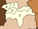
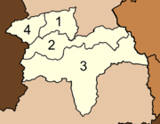
The district is subdivided into 4 subdistricts (tambonTambon
Tambon is a local government unit in Thailand. Below district and province , they form the third administrative subdivision level. As of the 2009 there are 7255 tambon, not including the 169 khwaeng of Bangkok, which are set at the same administrative level, thus every district contains 8-10 tambon...
), which are further subdivided into 33 villages (muban
Muban
Muban is the lowest administrative subdivision of Thailand. Usually translated as village, they are the subdivision of tambon. As of 2008, there are 74944 administrative villages in Thailand. As of the 1990 census, the average village consisted of 144 households or 746 persons.A muban does not...
). The township (thesaban tambon) of Khok Chang covers parts of the tambon Mae Wat.
|
 |

