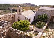
Aptera, Greece
Encyclopedia

Crete
Crete is the largest and most populous of the Greek islands, the fifth largest island in the Mediterranean Sea, and one of the thirteen administrative regions of Greece. It forms a significant part of the economy and cultural heritage of Greece while retaining its own local cultural traits...
, a kilometer inland from the southern shore of Souda Bay
Souda Bay
Souda Bay is a bay and natural harbour on the northwest coast of the Greek island of Crete. The bay is about 15 km long and only two to four km wide, and a deep natural harbour. It is formed between the Akrotiri peninsula and Cape Drapano, and runs west to east...
, about 13 kilometers east of Chania
Chania
Chaniá , , also transliterated Chania, Hania, and Xania, older form Chanea and Venetian Canea, Ottoman Turkish خانيه Hanya) is the second largest city of Crete and the capital of the Chania peripheral unit...
in the municipality of Akrotiri. It is mentioned (A-pa-ta-wa) in Linear B
Linear B
Linear B is a syllabic script that was used for writing Mycenaean Greek, an early form of Greek. It pre-dated the Greek alphabet by several centuries and seems to have died out with the fall of Mycenaean civilization...
tablets from the 14th-13th centuries BC. With its highly fortunate geographical situation, the city-state was powerful from Minoan
Minoan civilization
The Minoan civilization was a Bronze Age civilization that arose on the island of Crete and flourished from approximately the 27th century BC to the 15th century BC. It was rediscovered at the beginning of the 20th century through the work of the British archaeologist Arthur Evans...
through Hellenistic times, when it gradually declined. It was destroyed by earthquake
Earthquake
An earthquake is the result of a sudden release of energy in the Earth's crust that creates seismic waves. The seismicity, seismism or seismic activity of an area refers to the frequency, type and size of earthquakes experienced over a period of time...
during the 7th century. By the 12th century, a monastery
Monastery
Monastery denotes the building, or complex of buildings, that houses a room reserved for prayer as well as the domestic quarters and workplace of monastics, whether monks or nuns, and whether living in community or alone .Monasteries may vary greatly in size – a small dwelling accommodating only...
of St. John Theologos had been built on the site; it continued in operation until 1964. The site is now maintained by the Greek Ministry of Culture, Department of Antiquities. The hilltop, about 150 meters above the sea, commands views of Souda Bay
Souda Bay
Souda Bay is a bay and natural harbour on the northwest coast of the Greek island of Crete. The bay is about 15 km long and only two to four km wide, and a deep natural harbour. It is formed between the Akrotiri peninsula and Cape Drapano, and runs west to east...
and the Akrotiri Peninsula
Akrotiri (Crete)
Akrotiri is a peninsula and former municipality in the Chania peripheral unit, Crete, Greece. Since the 2011 local government reform it is part of the municipality Chania, of which it is a municipal unit. Its ancient name was Kiamon while the Byzantines called it Charaka...
to the north, the Lefka Ori (White Mountains)
Lefka Ori
Lefka Ori or Madares is a mountain range located in Western Crete, in the Chania prefecture. The White Mountains or Lefka Ori occupy a good part of the centre of West Crete and are the main feature of the region...
to the south, and Kalives
Kalives
Kalyves is a large village in Crete, Greece, the main village in the municipal unit of Armenoi. It is now a popular tourist resort that has maintained its Cretan character.-Description:...
and the Turkish
Ottoman Empire
The Ottoman EmpireIt was usually referred to as the "Ottoman Empire", the "Turkish Empire", the "Ottoman Caliphate" or more commonly "Turkey" by its contemporaries...
Itzendin Castle to the east; the city of Chania
Chania
Chaniá , , also transliterated Chania, Hania, and Xania, older form Chanea and Venetian Canea, Ottoman Turkish خانيه Hanya) is the second largest city of Crete and the capital of the Chania peripheral unit...
is not quite visible to the west.
There are several structures within the square monastery enclosure, including a chapel and a two-story block of monks' cells. The surrounding site is notable for a two-part temple from the 5th century BC, a large three-vaulted Roman cistern
Cistern
A cistern is a waterproof receptacle for holding liquids, usually water. Cisterns are often built to catch and store rainwater. Cisterns are distinguished from wells by their waterproof linings...
, Roman baths, and parts of several Doric
Doric Greek
Doric or Dorian was a dialect of ancient Greek. Its variants were spoken in the southern and eastern Peloponnese, Crete, Rhodes, some islands in the southern Aegean Sea, some cities on the coasts of Asia Minor, Southern Italy, Sicily, Epirus and Macedon. Together with Northwest Greek, it forms the...
temples. An ancient theater and a Roman peristyle villa have also been discovered on the site.
In the third century BC Aptera was at war with Kydonia, a prominent ancient city on northwestern Crete
Crete
Crete is the largest and most populous of the Greek islands, the fifth largest island in the Mediterranean Sea, and one of the thirteen administrative regions of Greece. It forms a significant part of the economy and cultural heritage of Greece while retaining its own local cultural traits...
. In much of the Greek Archaic Period
Archaic period in Greece
The Archaic period in Greece was a period of ancient Greek history that followed the Greek Dark Ages. This period saw the rise of the polis and the founding of colonies, as well as the first inklings of classical philosophy, theatre in the form of tragedies performed during Dionysia, and written...
, Aptera was under the control of Kydonia.

