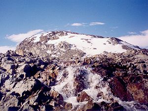
Atlantic Club Ridge
Encyclopedia

Hurd Peninsula
Hurd Peninsula is the land between South Bay and False Bay on the south coast of Livingston Island in the South Shetland Islands, Antarctica. The Spanish Antarctic base Juan Carlos I and the Bulgarian Antarctic base St. Kliment Ohridski are situated on the west coast of the peninsula.The feature...
in Eastern Livingston Island, Antarctica. To the west the ridge surmounts the South Bay
South Bay, Livingston Island
South Bay is a wide bay indenting for the south coast of Livingston Island in the South Shetland Islands, Antarctica. The bay is lying northwest of False Bay and east of Walker Bay, and is entered between Hannah Point and Miers Bluff....
coast north of Johnsons Dock
Johnsons Dock
Johnsons Dock is a sheltered 500 m wide cove indenting for 900 m the southeast coast of South Bay, Livingston Island in the South Shetland Islands, Antarctica. Entered north of Ballester Point. Surmounted by Charrúa Ridge on the northeast...
, to the south it is bounded by the lower course of the two km long Contell Glacier
Contell Glacier
Contell Glacier is the long and wide glacier on Hurd Peninsula, Livingston Island in the South Shetland Islands, Antarctica bounded by Atlantic Club Ridge to the northwest, Krum Rock to the north, Balkan Snowfield to the northeast, and Charrúa Ridge and Charrúa Gap to the south...
, to the east by the foot of the Balkan Snowfield
Balkan Snowfield
Balkan Snowfield is an ice-covered plateau ranging from 150 to 280 m in eastern Livingston Island in the South Shetland Islands, Western Antarctica...
sloping up towards Krum Rock
Krum Rock
Krum Rock is a small nunatak rising to 208 metres on the southwest edge of Balkan Snowfield just north of Contell Glacier on Hurd Peninsula in eastern Livingston Island, one of the South Shetland Islands in Western Antarctica. The rock projects slightly above the ice sheet with some 3,000 square...
and to the northwest by Sea Lion Tarn
Sea Lion Tarn
Sea Lion Tarn is a freshwater tarn with an area of located between Sea Lion Glacier and the north-western slopes of Atlantic Club Ridge on Hurd Peninsula in eastern Livingston Island in the South Shetland Islands, Antarctica...
. The ridge is snow-free in the summer months.
The ridge's steep northern slopes are linked with Hesperides Hill
Hesperides Hill
Hesperides Hill is a ridge linked by a saddle of elevation 52 m with the northern slopes of Atlantic Club Ridge on Hurd Peninsula, eastern Livingston Island in the South Shetland Islands, Antarctica...
by a saddle of 52 m elevation. The higher rocky ground on the Atlantic Club Ridge, as well as on the hills surmounting Bulgarian Beach
Bulgarian Beach
Bulgarian Beach is a coast in the north part of Hurd Peninsula, eastern Livingston Island, extending 2.3 km from Hespérides Point to the southwest to Perunika Glacier to the northeast, and forming the southeast coast of Emona Anchorage.The beach comprises four predominantly boulder beaches,...
, is noted for its abundant bushy-grown lichen
Lichen
Lichens are composite organisms consisting of a symbiotic organism composed of a fungus with a photosynthetic partner , usually either a green alga or cyanobacterium...
s, while moss
Moss
Mosses are small, soft plants that are typically 1–10 cm tall, though some species are much larger. They commonly grow close together in clumps or mats in damp or shady locations. They do not have flowers or seeds, and their simple leaves cover the thin wiry stems...
and Antarctic hair-grass (Deschampsia antarctica
Deschampsia antarctica
Deschampsia antarctica is one of two flowering plants native to Antarctica, the other being Colobanthus quitensis ....
) communities thrive on the guano
Guano
Guano is the excrement of seabirds, cave dwelling bats, and seals. Guano manure is an effective fertilizer due to its high levels of phosphorus and nitrogen and also its lack of odor. It was an important source of nitrates for gunpowder...
-enriched soil on top of larger rocks at the seaward hill feet.
In commemoration of the co-organizers of the 1993-94, 1994–95, and 1995-96 Bulgarian Antarctic campaigns the name Atlantic Club
Atlantic Club of Bulgaria
The Atlantic Club of Bulgaria is a non-governmental, non-partisan organization dedicated to fostering the common values of the Euro-Atlantic community.- Mission :...
was originally applied in 1994 to the neighbouring glacier but, due to priority of the existing Spanish
Spain
Spain , officially the Kingdom of Spain languages]] under the European Charter for Regional or Minority Languages. In each of these, Spain's official name is as follows:;;;;;;), is a country and member state of the European Union located in southwestern Europe on the Iberian Peninsula...
name (Glaciar Contell), the name was subsequently transferred to the present feature.
Location
The feature is 600 m long and 350 m wide, trending east by northeast to west by southwest, and is located at 62°38′56"S 60°21′54"W which is 730 m southeast of Hespérides Point, 950 m southwest of Sinemorets HillSinemorets Hill
Sinemorets Hill is the second most prominent in the chain of hills surmounting Bulgarian Beach in eastern Livingston Island in the South Shetland Islands, Antarctica....
and 1.29 km northwest of the highest point of Charrúa Ridge (333 m).
The ridge was mapped in detail by the Spanish Servicio Geográfico del Ejército in 1991.
Maps
- L.L. Ivanov et al. Antarctica: Livingston Island and Greenwich Island, South Shetland Islands. Scale 1:100000 topographic map. Sofia: Antarctic Place-names Commission of Bulgaria, 2005.
- L.L. Ivanov. Antarctica: Livingston Island and Greenwich, Robert, Snow and Smith Islands. Scale 1:120000 topographic map. Troyan: Manfred Wörner Foundation, 2009.

