Baldwyn, Mississippi
Encyclopedia

Lee County, Mississippi
-National protected areas:* Brices Cross Roads National Battlefield Site* Natchez Trace Parkway * Tupelo National Battlefield-History:On September 20, 1816, General Andrew Jackson, David Meriwether, and the Chickasaw Nation signed the Treaty of Chickasaw Council House in Lee County.Lee County was...
and Prentiss
Prentiss County, Mississippi
-Demographics:As of the census of 2000, there were 25,556 people, 9,821 households, and 7,169 families residing in the county. The population density was 62 people per square mile . There were 10,681 housing units at an average density of 26 per square mile...
Counties, Mississippi
Mississippi
Mississippi is a U.S. state located in the Southern United States. Jackson is the state capital and largest city. The name of the state derives from the Mississippi River, which flows along its western boundary, whose name comes from the Ojibwe word misi-ziibi...
, United States
United States
The United States of America is a federal constitutional republic comprising fifty states and a federal district...
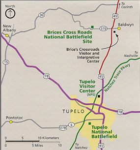
. Baldwyn is located on Highway 370, due north of Tupelo, Mississippi
Tupelo, Mississippi
Tupelo is the largest city in and the county seat of Lee County, Mississippi, United States. It is the seventh largest city in the state of Mississippi, smaller than Meridian, and larger than Greenville. As of the 2000 United States Census, the city's population was 34,211...
. It was incorporated by Act of the Legislature in Tishomingo and Itawamba Counties on April 1, 1861. The population was 3,321 at the 2000 census
United States Census, 2000
The Twenty-second United States Census, known as Census 2000 and conducted by the Census Bureau, determined the resident population of the United States on April 1, 2000, to be 281,421,906, an increase of 13.2% over the 248,709,873 persons enumerated during the 1990 Census...
.
History
Baldwyn is an outgrowth of the village of Carrollville: When the Mobile and Ohio RailroadMobile and Ohio Railroad
The Mobile and Ohio Railroad was a railroad in the Southern U.S. The M&O was chartered in January and February 1848 by the states of Alabama, Kentucky, Mississippi, and Tennessee. It was planned to span the distance between the seaport of Mobile, Alabama and the Ohio River near Cairo, Illinois...
was being built during the years of 1848 to 1861, it missed Carrollville by one and one-half miles and the citizens moved to the new town of Baldwyn which was named for the Civil Engineer who surveyed the road through the town. Tishomingo, Chief of the Chickasaws lived at old Carrollville but died at Little Rock, Arkansas
Little Rock, Arkansas
Little Rock is the capital and the largest city of the U.S. state of Arkansas. The Metropolitan Statistical Area had a population of 699,757 people in the 2010 census...
in 1839 of small pox while being moved west with his tribe. On March 16, 1942 two tornadoes, only twenty-five minutes apart, struck Baldwyn and killed 65 persons.
Geography
Baldwyn is located at 34°30′32"N 88°38′22"W (34.508943, -88.639436). The city straddles the boundary between Prentiss County on the north and Lee County on the south. In the 2000 census, 1,892 of the city's 3,321 residents (57.0%) lived in Prentiss County and 1,429 (43.0%) in Lee County.According to the United States Census Bureau
United States Census Bureau
The United States Census Bureau is the government agency that is responsible for the United States Census. It also gathers other national demographic and economic data...
, the city has a total area of 11.6 square miles (30.0 km²), of which, 11.5 square miles (29.9 km²) of it is land and 0.1 square miles (0.1 km²) of it (0.43%) is water.
Demographics
As of the censusCensus
A census is the procedure of systematically acquiring and recording information about the members of a given population. It is a regularly occurring and official count of a particular population. The term is used mostly in connection with national population and housing censuses; other common...
of 2000, there were 3,321 people, 1,331 households, and 886 families residing in the city. The population density
Population density
Population density is a measurement of population per unit area or unit volume. It is frequently applied to living organisms, and particularly to humans...
was 287.9 sq mi). There were 1,472 housing units at an average density of 127.6 per square mile. The racial makeup of the city was 54.53% White, 43.87% African American, 0.24% Native American, 0.30% from other races
Race (United States Census)
Race and ethnicity in the United States Census, as defined by the Federal Office of Management and Budget and the United States Census Bureau, are self-identification data items in which residents choose the race or races with which they most closely identify, and indicate whether or not they are...
, and 1.05% from two or more races. Hispanic or Latino of any race were 0.99% of the population.
There were 1,331 households out of which 33.1% had children under the age of 18 living with them, 42.2% were married couples
Marriage
Marriage is a social union or legal contract between people that creates kinship. It is an institution in which interpersonal relationships, usually intimate and sexual, are acknowledged in a variety of ways, depending on the culture or subculture in which it is found...
living together, 20.2% had a female householder with no husband present, and 33.4% were non-families. 31.5% of all households were made up of individuals and 15.7% had someone living alone who was 65 years of age or older. The average household size was 2.42 and the average family size was 3.02.
In the city the population was spread out with 26.8% under the age of 18, 9.7% from 18 to 24, 24.1% from 25 to 44, 21.4% from 45 to 64, and 18.0% who were 65 years of age or older. The median age was 36 years. For every 100 females there were 79.9 males. For every 100 females age 18 and over, there were 73.5 males.
The median income for a household in the city was $26,016, and the median income for a family was $37,598. Males had a median income of $27,162 versus $21,174 for females. The per capita income
Per capita income
Per capita income or income per person is a measure of mean income within an economic aggregate, such as a country or city. It is calculated by taking a measure of all sources of income in the aggregate and dividing it by the total population...
for the city was $15,430. About 19.9% of families and 24.0% of the population were below the poverty line, including 32.9% of those under age 18 and 23.3% of those age 65 or over.
Transportation
The Booneville/Baldwyn AirportBooneville/Baldwyn Airport
Booneville/Baldwyn Airport is a public use airport in Prentiss County, Mississippi, United States. It is owned by the cities of Booneville and Baldwyn, and located six nautical miles southwest of the central business district of Booneville...
is owned by the cities of Booneville
Booneville, Mississippi
Booneville is a city in Prentiss County, Mississippi, United States. The population was 8,625 at the 2000 census. It is the county seat of Prentiss County....
and Baldwyn. It is located in Prentiss County
Prentiss County, Mississippi
-Demographics:As of the census of 2000, there were 25,556 people, 9,821 households, and 7,169 families residing in the county. The population density was 62 people per square mile . There were 10,681 housing units at an average density of 26 per square mile...
, six nautical miles (7 mi, 11 km) southwest of Booneville's central business district
Central business district
A central business district is the commercial and often geographic heart of a city. In North America this part of a city is commonly referred to as "downtown" or "city center"...
.

