
Balhinch, Indiana
Encyclopedia
Balhinch is two-mile-square unincorporated area
in Union Township
, Montgomery County
, Indiana
, United States
. Balhinch includes Rattlesnake Canyon and Weir Cemetery.
in February 1821, five miles southwest of Crawfordsville
in Section 21 in an area with two streams — Sugar Creek
and Offield's Creek. A monument
to William Offield stands near Offield's Creek.
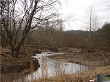
Offield Creek is more commonly known by locals as Rattlesnake Creek. This is due to its winding shape, much like a rattlesnake ready to strike. The creek has many sand and rock bottoms. Freshwater springs feed into the creek. Rattlesnake Creek's valley has some large bluffs and cliffs.
It was formally platted
in the 1920s and the boundaries legally defined.
Unincorporated area
In law, an unincorporated area is a region of land that is not a part of any municipality.To "incorporate" in this context means to form a municipal corporation, a city, town, or village with its own government. An unincorporated community is usually not subject to or taxed by a municipal government...
in Union Township
Union Township, Montgomery County, Indiana
Union Township is one of eleven townships in Montgomery County, Indiana, USA. As of the 2000 census, its population was 23,837. Wabash College is located in Crawfordsville in this township.-Geography:...
, Montgomery County
Montgomery County, Indiana
Montgomery County is a county located in the U.S. state of Indiana. As of 2010, the population was 38,124. The county seat is Crawfordsville-Early history and settlement:...
, Indiana
Indiana
Indiana is a US state, admitted to the United States as the 19th on December 11, 1816. It is located in the Midwestern United States and Great Lakes Region. With 6,483,802 residents, the state is ranked 15th in population and 16th in population density. Indiana is ranked 38th in land area and is...
, United States
United States
The United States of America is a federal constitutional republic comprising fifty states and a federal district...
. Balhinch includes Rattlesnake Canyon and Weir Cemetery.
History
The Balhinch area was originally settled by William OffieldWilliam Offield
In 1821, William Offield built a cabin on a creek, , four miles southwest of the future site of Crawfordsville, Indiana in an area now known as Balhinch...
in February 1821, five miles southwest of Crawfordsville
Crawfordsville, Indiana
Crawfordsville is a city in Union Township, Montgomery County, Indiana, United States. As of the 2010 census, the city had a population of 15,915. The city is the county seat of Montgomery County...
in Section 21 in an area with two streams — Sugar Creek
Sugar Creek (Western Indiana)
Sugar Creek is a waterway located in the U.S. state of Indiana. It originates in a farm field approximately two miles south-southwest of Kempton, Indiana, and travels west-southwest for about before merging with the Wabash River north of Montezuma...
and Offield's Creek. A monument
Monument
A monument is a type of structure either explicitly created to commemorate a person or important event or which has become important to a social group as a part of their remembrance of historic times or cultural heritage, or simply as an example of historic architecture...
to William Offield stands near Offield's Creek.
Offield Creek is more commonly known by locals as Rattlesnake Creek. This is due to its winding shape, much like a rattlesnake ready to strike. The creek has many sand and rock bottoms. Freshwater springs feed into the creek. Rattlesnake Creek's valley has some large bluffs and cliffs.
It was formally platted
Plat
A plat in the U.S. is a map, drawn to scale, showing the divisions of a piece of land. Other English-speaking countries generally call such documents a cadastral map or plan....
in the 1920s and the boundaries legally defined.