Baltic ice lake
Encyclopedia

Baltic Sea
The Baltic Sea is a brackish mediterranean sea located in Northern Europe, from 53°N to 66°N latitude and from 20°E to 26°E longitude. It is bounded by the Scandinavian Peninsula, the mainland of Europe, and the Danish islands. It drains into the Kattegat by way of the Øresund, the Great Belt and...
basin as glaciation
Glacier
A glacier is a large persistent body of ice that forms where the accumulation of snow exceeds its ablation over many years, often centuries. At least 0.1 km² in area and 50 m thick, but often much larger, a glacier slowly deforms and flows due to stresses induced by its weight...
retreated from that region at the end of the Pleistocene
Pleistocene
The Pleistocene is the epoch from 2,588,000 to 11,700 years BP that spans the world's recent period of repeated glaciations. The name pleistocene is derived from the Greek and ....
. The lake, dated to 12,600-10,300 BP, is roughly contemporaneous with the three Pleistocene
Pleistocene
The Pleistocene is the epoch from 2,588,000 to 11,700 years BP that spans the world's recent period of repeated glaciations. The name pleistocene is derived from the Greek and ....
Blytt-Sernander
Blytt-Sernander
The Blytt-Sernander classification, or sequence, is a series of north European climatic periods or phases based on the study of Danish peat bogs by Axel Blytt and Rutger Sernander...
periods. The lake followed a period of massive glaciation in the region, which followed the end of the Eemian Sea
Eemian sea
The Eemian sea was a body of water located approximately where the Baltic sea is now during the last or Eemian Stage, MIS 5e, roughly 130,000 to 115,000 BP. Sea level was 5 to 7 metres higher globally than it is today, due to the prior release of glacial water...
. The post-glacial Yoldia Sea
Yoldia Sea
Yoldia Sea is a name given by geologists to a variable brackish-water stage in the Baltic Sea basin that prevailed after the Baltic ice lake was drained to sea level during the Weichsel glaciation...
was immediately subsequent to the Baltic ice lake.
Phenomena related to ice lake and sea formation

Lake
A lake is a body of relatively still fresh or salt water of considerable size, localized in a basin, that is surrounded by land. Lakes are inland and not part of the ocean and therefore are distinct from lagoons, and are larger and deeper than ponds. Lakes can be contrasted with rivers or streams,...
is used to mean a body of primarily fresh water. A sea is filled with brackish or salt water. In the history of the Baltic Sea, the distinction is not always clear. Salinity has varied with location, depth and time.
The main factors are the advance or recession of the Scandinavian glacier and the isostatic sinking of the landforms due to the weight of ice or isostatic rebound (springing back) when relieved of it. The glacier provides a massive flow of fresh water. Salt water enters from the North Sea
North Sea
In the southwest, beyond the Straits of Dover, the North Sea becomes the English Channel connecting to the Atlantic Ocean. In the east, it connects to the Baltic Sea via the Skagerrak and Kattegat, narrow straits that separate Denmark from Norway and Sweden respectively...
through straits when the sea level is high enough to allow reverse flow over the sill. When the straits are above sea level or close to sea level, fresh water will accumulate and a lake forms. Fresh water will accumulate to levels substantially higher than sea level when the sills are substantially above sea level. The release of fresh water from the glaciers depends on climate; the presence or absence of entrances to the Ocean depends on land rise and oceanic water level; the latter of course is also affected by the amount of ice held in glaciers worldwide.
Several methods are used to determine the quality (temperature, salinity, solids content) of ancient sea water. The main one is the type of diatoms found in the sediment. Some species require salt water, while others require fresh. Other invertebrates serve as marker species as well. Also, periods of maximum supply from melt water are marked by low organic carbon in the sediment. Higher carbon content causes greater deposition of iron sulfide, which appears as a black varve.
Formation

Lake Gardno
Gardno is a lake in the Słowińskie Lakeland in Pomeranian Voivodship, Poland. It is the part of Słowiński National Park. Its area is 24.69 km². It is 6.8 km long and 4.7 km wide. Maximum depth is 2.6 m.- External links :* and - photos...
end-moraines of northern Poland
Poland
Poland , officially the Republic of Poland , is a country in Central Europe bordered by Germany to the west; the Czech Republic and Slovakia to the south; Ukraine, Belarus and Lithuania to the east; and the Baltic Sea and Kaliningrad Oblast, a Russian exclave, to the north...
at around 14,000 BP and reached the southern shore of the Baltic Sea in the time window, 13,500/13,000 BP. In the next several hundred years, closed fresh water pools formed in the southern Baltic region from melt water as the ice retreated northward. These were about 40 metres above the current sea level.
By 12,000 BP the edge of the glacier was at a line across southern Sweden
Sweden
Sweden , officially the Kingdom of Sweden , is a Nordic country on the Scandinavian Peninsula in Northern Europe. Sweden borders with Norway and Finland and is connected to Denmark by a bridge-tunnel across the Öresund....
to the northern shore of the Baltic countries. A connected body of water, the Ramsay Sea, stretched from the Danish
Denmark
Denmark is a Scandinavian country in Northern Europe. The countries of Denmark and Greenland, as well as the Faroe Islands, constitute the Kingdom of Denmark . It is the southernmost of the Nordic countries, southwest of Sweden and south of Norway, and bordered to the south by Germany. Denmark...
islands region to the shores of Estonia
Estonia
Estonia , officially the Republic of Estonia , is a state in the Baltic region of Northern Europe. It is bordered to the north by the Gulf of Finland, to the west by the Baltic Sea, to the south by Latvia , and to the east by Lake Peipsi and the Russian Federation . Across the Baltic Sea lies...
. The Gulfs of Bothnia
Gulf of Bothnia
The Gulf of Bothnia is the northernmost arm of the Baltic Sea. It is situated between Finland's west coast and Sweden's east coast. In the south of the gulf lie the Åland Islands, between the Sea of Åland and the Archipelago Sea.-Name:...
and Finland
Gulf of Finland
The Gulf of Finland is the easternmost arm of the Baltic Sea. It extends between Finland and Estonia all the way to Saint Petersburg in Russia, where the river Neva drains into it. Other major cities around the gulf include Helsinki and Tallinn...
were still glaciated. In the Allerød
Allerød Oscillation
The Allerød period was a warm and moist global interstadial that occurred at the end of the last glacial period. The Allerød oscillation raised temperatures , before they declined again in the succeeding Younger Dryas period, which was followed by the present interglacial period.In some regions,...
warm period, rising land in the Denmark region created the Baltic ice lake. It egressed through a small channel in the Strait of Øresund. The lake was higher than sea level (which itself was lower than the present-day sea level) by some tens of metres. Lake Ladoga
Lake Ladoga
Lake Ladoga is a freshwater lake located in the Republic of Karelia and Leningrad Oblast in northwestern Russia, not far from Saint Petersburg. It is the largest lake in Europe, and the 14th largest lake by area in the world.-Geography:...
was part of it.
Emergence of the land then closed the channel through the Strait of Öresund
Oresund
The Sound , is the strait that separates the Danish island Zealand from the southern Swedish province of Scania. Its width is just at the narrowest point between Helsingør, Denmark, and Helsingborg, Sweden...
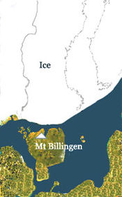
. The lake rose until at about 11,200 BP it broke through a narrow corridor in the region of Mount Billingen
Billingen
Billingen is the largest of the thirteen mesas in the Swedish county of Västra Götaland, with a maximum altitude of . The mesa extends in a north-southerly direct with a length of and a width of ....
in present-day south-west Sweden; this used to be described by quaternary geologists as a massive, single tap of Niagara
Niagara Falls
The Niagara Falls, located on the Niagara River draining Lake Erie into Lake Ontario, is the collective name for the Horseshoe Falls and the adjacent American Falls along with the comparatively small Bridal Veil Falls, which combined form the highest flow rate of any waterfalls in the world and has...
-like force but it is now considered more likely that it happened in several steps over a limited period, perhaps a century, and along different local troughs and passages. By 10,800 BP, the lake had dropped 55 metres. At that point the climate reverted into cooling and during the Younger Dryas
Younger Dryas
The Younger Dryas stadial, also referred to as the Big Freeze, was a geologically brief period of cold climatic conditions and drought between approximately 12.8 and 11.5 ka BP, or 12,800 and 11,500 years before present...
cold climate period, the glacier advanced again over the central Swedish exit. The lake was blocked again, rose about 25 metres and broke through the Strait of Oresund. By now, the Gulf of Finland
Gulf of Finland
The Gulf of Finland is the easternmost arm of the Baltic Sea. It extends between Finland and Estonia all the way to Saint Petersburg in Russia, where the river Neva drains into it. Other major cities around the gulf include Helsinki and Tallinn...
had been deglaciated.
At the peak of this high water phase, most of Finland
Finland
Finland , officially the Republic of Finland, is a Nordic country situated in the Fennoscandian region of Northern Europe. It is bordered by Sweden in the west, Norway in the north and Russia in the east, while Estonia lies to its south across the Gulf of Finland.Around 5.4 million people reside...
was under water, including Helsinki
Helsinki
Helsinki is the capital and largest city in Finland. It is in the region of Uusimaa, located in southern Finland, on the shore of the Gulf of Finland, an arm of the Baltic Sea. The population of the city of Helsinki is , making it by far the most populous municipality in Finland. Helsinki is...
, at a depth of 115 metres; only southern Sweden was free of ice. The Danish Islands were all connected west of the Strait of Oresund. Around 10,500 BP the climate became warmer, the ice retreated to the north of Mount Billingen, and the waters broke through central Sweden again, providing a second egress. Water level dropped 25 metres to the sea level of that time.
Summary
At about 14000 BC the retreating ice had reached the southern shores of the present Baltic. Melt water formed extensive lacustrine systems still visible today in north Russia, Poland and Germany. By 12,600 BC the Baltic ice lake had come into existence. Beyond it only southern Sweden was habitable, and it was an island. It is well known that Scandinavia means "the island of Scandza" or "ScandiaScandia
Scandia was a name used for various uncharted islands in Northern Europe by the first Greek and Roman geographers. The name originated in Greek sources, where it had been used for a long time for different islands in the Mediterranean region...
", which cannot be accounted for by today's map, and is generally assumed to be an inadvertent misrepresentation by ancient geographers. However, the first Scandinavia was an island, and was identical to southern Sweden.
Several carbon-dated sites in Estonia indicate that human habitation of the shores of the Baltic ice lake began in the Boreal period, in the time window 11,200-10,200 BP. Charcoal, animal bones, and artifacts from Mesolithic
Mesolithic
The Mesolithic is an archaeological concept used to refer to certain groups of archaeological cultures defined as falling between the Paleolithic and the Neolithic....
temporary settlements have been found at Pulli and in the Lake Ladoga
Lake Ladoga
Lake Ladoga is a freshwater lake located in the Republic of Karelia and Leningrad Oblast in northwestern Russia, not far from Saint Petersburg. It is the largest lake in Europe, and the 14th largest lake by area in the world.-Geography:...
region. The diet included roe deer
Roe Deer
The European Roe Deer , also known as the Western Roe Deer, chevreuil or just Roe Deer, is a Eurasian species of deer. It is relatively small, reddish and grey-brown, and well-adapted to cold environments. Roe Deer are widespread in Western Europe, from the Mediterranean to Scandinavia, and from...
, red deer
Red Deer
The red deer is one of the largest deer species. Depending on taxonomy, the red deer inhabits most of Europe, the Caucasus Mountains region, Asia Minor, parts of western Asia, and central Asia. It also inhabits the Atlas Mountains region between Morocco and Tunisia in northwestern Africa, being...
, marten
Marten
The martens constitute the genus Martes within the subfamily Mustelinae, in family Mustelidae.-Description:Martens are slender, agile animals, adapted to living in taigas, and are found in coniferous and northern deciduous forests across the northern hemisphere. They have bushy tails, and large...
, otter
Otter
The Otters are twelve species of semi-aquatic mammals which feed on fish and shellfish, and also other invertebrates, amphibians, birds and small mammals....
, wolf, bear
Bear
Bears are mammals of the family Ursidae. Bears are classified as caniforms, or doglike carnivorans, with the pinnipeds being their closest living relatives. Although there are only eight living species of bear, they are widespread, appearing in a wide variety of habitats throughout the Northern...
and ringed seal
Ringed Seal
The ringed seal , also known as the jar seal and as netsik or nattiq by the Inuit, is an earless seal inhabiting the Arctic and sub-Arctic regions...
. An open pine-birch forest covered the region. Pollen from Pinus, Betula, Alnus, Rosaceae
Rosaceae
Rosaceae are a medium-sized family of flowering plants, including about 2830 species in 95 genera. The name is derived from the type genus Rosa. Among the largest genera are Alchemilla , Sorbus , Crataegus , Cotoneaster , and Rubus...
, Cyperaceae
Cyperaceae
Cyperaceae are a family of monocotyledonous graminoid flowering plants known as sedges, which superficially resemble grasses or rushes. The family is large, with some 5,500 species described in about 109 genera. These species are widely distributed, with the centers of diversity for the group...
and Artemisia
Artemisia (plant)
Artemisia is a large, diverse genus of plants with between 200 to 400 species belonging to the daisy family Asteraceae. It comprises hardy herbs and shrubs known for their volatile oils. They grow in temperate climates of the Northern Hemisphere and Southern Hemisphere, usually in dry or semi-dry...
have been found.
Around 10,300 BP, the ice lake discharged through channels that opened in central Sweden (near Mount Billingen
Billingen
Billingen is the largest of the thirteen mesas in the Swedish county of Västra Götaland, with a maximum altitude of . The mesa extends in a north-southerly direct with a length of and a width of ....
) until it reached the ocean level. The Yoldia Sea
Yoldia Sea
Yoldia Sea is a name given by geologists to a variable brackish-water stage in the Baltic Sea basin that prevailed after the Baltic ice lake was drained to sea level during the Weichsel glaciation...
phase began (10,300-9,500 BP).

