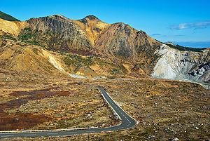
Bandai-Azuma Roadway
Encyclopedia

Toll road
A toll road is a privately or publicly built road for which a driver pays a toll for use. Structures for which tolls are charged include toll bridges and toll tunnels. Non-toll roads are financed using other sources of revenue, most typically fuel tax or general tax funds...
in Fukushima Prefecture
Fukushima Prefecture
is a prefecture of Japan located in the Tōhoku region on the island of Honshu. The capital is the city of Fukushima.-History:Until the Meiji Restoration, the area of Fukushima prefecture was known as Mutsu Province....
in the Tohoku region
Tohoku region
The is a geographical area of Japan. The region occupies the northeastern portion of Honshu, the largest island of Japan. The region consists of six prefectures : Akita, Aomori, Fukushima, Iwate, Miyagi and Yamagata....
, of Honshu
Honshu
is the largest island of Japan. The nation's main island, it is south of Hokkaido across the Tsugaru Strait, north of Shikoku across the Inland Sea, and northeast of Kyushu across the Kanmon Strait...
, Japan
Japan
Japan is an island nation in East Asia. Located in the Pacific Ocean, it lies to the east of the Sea of Japan, China, North Korea, South Korea and Russia, stretching from the Sea of Okhotsk in the north to the East China Sea and Taiwan in the south...
. It is managed by the .
Opening in November 1959, the roadway was created to allow visitors to the Tohoku area sightseeing access to the Azuma Mountain Range. The project was part of a larger plan to open up the Bandai-Asahi National Park
Bandai-Asahi National Park
is a national park in the Tohoku region, Honshū, Japan. The park site straddles over Fukushima Prefecture, Yamagata Prefecture, and Niigata Prefecture. The park was designated as a national park on September 5, 1950...
to tourism. The completed road runs from Fukushima City's Takayu Hot Springs to for a total distance of 28.7 km.
The roadway passes directly next to the crater of Mt. Azuma, so visitors who so desire can park their cars in the nearby visitor center and take the short hike up to the crater's rim.
For successfully displaying the sheer scale of the country's Azuma Mountain Range to the visitors of the toll road, the Bandai-Azuma Roadway was selected by the Japanese Ministry of Construction
Ministry of Land, Infrastructure and Transport (Japan)
The , abbreviated MLIT, is a ministry of the Japanese government. It is responsible for one-third of all the laws and orders in Japan and the largest Japanese ministry in terms of employees, as well as the second-largest organ of the Japanese government after the Ministry of Defense...
as one of the top 100 roads in Japan.
Due to heavy snowfall in the winter, every year the road is closed from mid-November until early April. As of the 2009 season, fares are ¥150 for bicycles, ¥1,150 for motorcycles and light cars, and ¥1,570 for normal-sized cars.

