

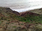
Barnes Chine
Encyclopedia
Isle of Wight
The Isle of Wight is a county and the largest island of England, located in the English Channel, on average about 2–4 miles off the south coast of the county of Hampshire, separated from the mainland by a strait called the Solent...
, England
England
England is a country that is part of the United Kingdom. It shares land borders with Scotland to the north and Wales to the west; the Irish Sea is to the north west, the Celtic Sea to the south west, with the North Sea to the east and the English Channel to the south separating it from continental...
. The chine lies just to the west of a small rise called Barnes High and south west of the hamlet of Yafford
Yafford
Yafford is a hamlet on the Isle of Wight . It is located nine kilometres from Newport in the southwest of the island an area known as the Back of the Wight between Brighstone and Niton. It has a non operational water mill, which was working until 1970. The mill has an overshot water wheel, powered...
. It is a small sandy coastal ravine, one of a number of such chine
Chine
A chine is a steep-sided river valley where the river flows through coastal cliffs to the sea. Typically these are soft eroding cliffs such as sandstone or clays. The word chine originates from the Saxon "Cinan" meaning a gap or yawn....
s on the island created by erosion of the cliff edge made of soft Cretaceous
Cretaceous
The Cretaceous , derived from the Latin "creta" , usually abbreviated K for its German translation Kreide , is a geologic period and system from circa to million years ago. In the geologic timescale, the Cretaceous follows the Jurassic period and is followed by the Paleogene period of the...
rock .
This Chine is difficult to identify as there is no obvious stream valley leading to the cliff edge, just a slight undulation of the gently sloping agricultural land. At the bottom of the undulation look over the cliff edge to see a small v-shaped gully descending rapidly to the beach below. The erosion of this chine is by underwater streams which emerge below the cliff top. The water probably comes from a small pond about 150m from the cliff edge near the Military Road and from the small catchement area to the west of Barnes High.
The Isle of Wight Coastal Path
Isle of Wight Coastal Path
.There are a couple of cafes on the cliff path which I believe are open in the summer months. The only public convenience on the cliff path now appears to be closed permanently ....
runs past the top of the chine.