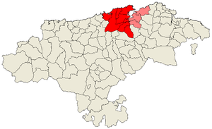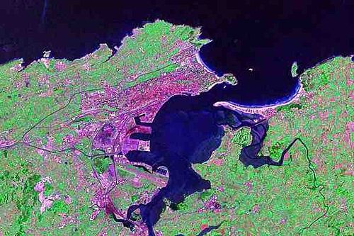
Bay of Santander
Encyclopedia

Comarca
A comarca is a traditional region or local administrative division found in parts of Spain, Portugal, Panama, Nicaragua, and Brazil. The term is derived from the term marca, meaning a "march, mark", plus the prefix co- meaning "together, jointly".The comarca is known in Aragonese as redolada and...
of Cantabria
Cantabria
Cantabria is a Spanish historical region and autonomous community with Santander as its capital city. It is bordered on the east by the Basque Autonomous Community , on the south by Castile and León , on the west by the Principality of Asturias, and on the north by the Cantabrian Sea.Cantabria...
and the largest estuary
Estuary
An estuary is a partly enclosed coastal body of water with one or more rivers or streams flowing into it, and with a free connection to the open sea....
on the North coast of Spain
Spain
Spain , officially the Kingdom of Spain languages]] under the European Charter for Regional or Minority Languages. In each of these, Spain's official name is as follows:;;;;;;), is a country and member state of the European Union located in southwestern Europe on the Iberian Peninsula...
, with an extension of 22.42 km² 9km long and 5 km wide. Due to the influence of Santander
Santander, Cantabria
The port city of Santander is the capital of the autonomous community and historical region of Cantabria situated on the north coast of Spain. Located east of Gijón and west of Bilbao, the city has a population of 183,446 .-History:...
and its metropolitan area, nearly half of the population of the region is gathered around it, which makes the anthropic pressure on this area of water quite notable.
The entrance to the Bay is lined by the Sardinero beaches, where the Isle of Mouro with its lighthouse
Lighthouse
A lighthouse is a tower, building, or other type of structure designed to emit light from a system of lamps and lenses or, in older times, from a fire, and used as an aid to navigation for maritime pilots at sea or on inland waterways....
can be found. The access to its interior is through a narrow channel of water between the Magdalena Peninsula
Magdalena Peninsula
The Magdalena Peninsula is a 69 acre peninsula located near the entrance to the Bay of Santander in the city of Santander, Cantabria along the north coast of Spain.The peninsula is a popular recreational destination for both tourists and locals...
, near to whom are the Isle of the Tower and Horadada Island; and the sandbanks of the El Puntal, a long series of beaches and dunes that protect the tranquil inner waters of the Bay.
The morphology of the bay has suffered important changes in the last centuries. It is estimated that more than 50% of the original extension has been filled up, drying up a large amount of marsh
Marsh
In geography, a marsh, or morass, is a type of wetland that is subject to frequent or continuous flood. Typically the water is shallow and features grasses, rushes, reeds, typhas, sedges, other herbaceous plants, and moss....
area for grasslands, to expand the Port of Santander, and to create new industrial and residential areas. At the moment, work is going on to recover the seaside ecosystem in some areas of high ecological value.
Rivers and rias
Several river courses flow into the Bay of Santander. The mostimportant of them is the Solía in the South;
there is also the Ria of San Salvador whose water empties
in the center of the Bay via the Ria of Astillero; in its
East margin flow the rias of Carmen and
Raos; to the West is the ria de Cubas,
which is the mouth of the Miera River.

Geology
The Santander Bay is formed by a diapirDiapir
A diapir is a type of intrusion in which a more mobile and ductily-deformable material is forced into brittle overlying rocks. Depending on the tectonic environment, diapirs can range from idealized mushroom-shaped Rayleigh-Taylor instability-type structures in regions with low tectonic stress...
generated during the alpinotype orogeny of the Tertiary
Tertiary
The Tertiary is a deprecated term for a geologic period 65 million to 2.6 million years ago. The Tertiary covered the time span between the superseded Secondary period and the Quaternary...
period. Its materials are composed of clay
Clay
Clay is a general term including many combinations of one or more clay minerals with traces of metal oxides and organic matter. Geologic clay deposits are mostly composed of phyllosilicate minerals containing variable amounts of water trapped in the mineral structure.- Formation :Clay minerals...
s and salt
Salt
In chemistry, salts are ionic compounds that result from the neutralization reaction of an acid and a base. They are composed of cations and anions so that the product is electrically neutral...
s (specially Keuper
Keuper
The Keuper is a lithostratigraphic unit in the subsurface of large parts of west and central Europe. The Keuper consists of dolostone, shales or claystones and evaporites that were deposited during the Middle and Late Triassic epochs...
's gypsum
Gypsum
Gypsum is a very soft sulfate mineral composed of calcium sulfate dihydrate, with the chemical formula CaSO4·2H2O. It is found in alabaster, a decorative stone used in Ancient Egypt. It is the second softest mineral on the Mohs Hardness Scale...
s) that ascended taking advantage of the faults
Geologic fault
In geology, a fault is a planar fracture or discontinuity in a volume of rock, across which there has been significant displacement along the fractures as a result of earth movement. Large faults within the Earth's crust result from the action of tectonic forces...
. This movement generated an increase of the fracturing and an important dragging of rocks from the outer layers. The weakness zone generated by the Keuper's clays made easier its erosion compared with other sandstone
Sandstone
Sandstone is a sedimentary rock composed mainly of sand-sized minerals or rock grains.Most sandstone is composed of quartz and/or feldspar because these are the most common minerals in the Earth's crust. Like sand, sandstone may be any colour, but the most common colours are tan, brown, yellow,...
or limestone
Limestone
Limestone is a sedimentary rock composed largely of the minerals calcite and aragonite, which are different crystal forms of calcium carbonate . Many limestones are composed from skeletal fragments of marine organisms such as coral or foraminifera....
areas, which involved the advance of the sea and the formation of the bay.


