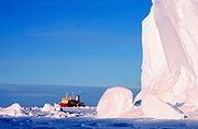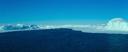
Bay of Whales
Encyclopedia

Iceport
An iceport is a a more-or-less permanent indentation in the front of an ice shelf, that can serve as a natural ice harbor. Though useful, they are not always reliable, as calving of surrounding ice shelves can render an iceport temporarily unstable and unusable.-Historical and present use of...
, indenting the front of Ross Ice Shelf
Ross Ice Shelf
The Ross Ice Shelf is the largest ice shelf of Antarctica . It is several hundred metres thick. The nearly vertical ice front to the open sea is more than 600 km long, and between 15 and 50 metres high above the water surface...
just north of Roosevelt Island
Roosevelt Island, Antarctica
Roosevelt Island is an ice-covered island, about long in a NW-SE direction, wide and about in area, lying in the eastern part of the Ross Ice Shelf of Antarctica...
. It is the southernmost point of open ocean not only of the Ross Sea
Ross Sea
The Ross Sea is a deep bay of the Southern Ocean in Antarctica between Victoria Land and Marie Byrd Land.-Description:The Ross Sea was discovered by James Ross in 1841. In the west of the Ross Sea is Ross Island with the Mt. Erebus volcano, in the east Roosevelt Island. The southern part is covered...
, but worldwide. The Ross Sea does extend much further south, but that area is covered by the Ross Ice Shelf.
Discovery and naming
The feature was named by Ernest ShackletonErnest Shackleton
Sir Ernest Henry Shackleton, CVO, OBE was a notable explorer from County Kildare, Ireland, who was one of the principal figures of the period known as the Heroic Age of Antarctic Exploration...
in the Nimrod on January 24, 1908, because of the large number of whale
Whale
Whale is the common name for various marine mammals of the order Cetacea. The term whale sometimes refers to all cetaceans, but more often it excludes dolphins and porpoises, which belong to suborder Odontoceti . This suborder also includes the sperm whale, killer whale, pilot whale, and beluga...
s seen at this location.
The Bay of Whales served as the base for several important Antarctic expeditions, including:
- 1910–1912: Amundsen's South Pole expeditionAmundsen's South Pole expeditionThe first expedition to reach the geographic South Pole was led by the Norwegian explorer Roald Amundsen. He and four others arrived at the pole on 14 December 1911, five weeks ahead of a British party led by Robert Falcon Scott...
, led by Roald AmundsenRoald AmundsenRoald Engelbregt Gravning Amundsen was a Norwegian explorer of polar regions. He led the first Antarctic expedition to reach the South Pole between 1910 and 1912 and he was the first person to reach both the North and South Poles. He is also known as the first to traverse the Northwest Passage.... - 1928–1930: Richard Evelyn ByrdRichard Evelyn ByrdRear Admiral Richard Evelyn Byrd, Jr., USN was a naval officer who specialized in feats of exploration. He was a pioneering American aviator, polar explorer, and organizer of polar logistics...
– First expedition - 1933–1935: Richard Evelyn Byrd – Second expedition
- 1939–1941: United States Antarctic Service ExpeditionUnited States Antarctic Service ExpeditionThe United States Antarctic Service Expedition , often referred to as Byrd’s third Antarctic Expedition, was an expedition jointly sponsored by the United States Navy, State Department, Department of the Interior and The Treasury...
, led by Richard Evelyn Byrd
The configuration of the Bay of Whales is continuously changing. A survey by the Byrd expedition in 1934 determined that the feature lay at the junction of two separate ice systems, the movements of which are influenced by the presence of Roosevelt Island. Commander Glen Jacobsen, USN
United States Navy
The United States Navy is the naval warfare service branch of the United States Armed Forces and one of the seven uniformed services of the United States. The U.S. Navy is the largest in the world; its battle fleet tonnage is greater than that of the next 13 largest navies combined. The U.S...
, who visited in the USS Atka
USCGC Southwind (WAGB-280)
USCGC Southwind was a Wind-class icebreaker that served in the United States Coast Guard as USCGC Southwind , the Soviet Navy as the Admiral Makarov, the United States Navy as USS Atka and again in the U.S...
in January 1955, found that calving of the ice shelf
Ice shelf
An ice shelf is a thick, floating platform of ice that forms where a glacier or ice sheet flows down to a coastline and onto the ocean surface. Ice shelves are only found in Antarctica, Greenland and Canada. The boundary between the floating ice shelf and the grounded ice that feeds it is called...
rendered the iceport temporarily unusable.

See also
- FramheimFramheimFramheim was the name of explorer Roald Amundsen's base at the Bay of Whales on the Ross Ice Shelf in Antarctica during his quest for the South Pole...
- Walvisbaai (synonymous name, but tropical: in southwest Africa)
- Ice pierIce pierAn ice pier is a man-made structure used to assist the unloading of ships in Antarctica. It is constructed by pumping seawater into a contained area and allowing the water to freeze. By repeating this procedure several times, additional layers are built up. The final structure is many metres in...
- Atka IceportAtka IceportAtka Iceport, also known as Atka Bay, is an iceport about long and wide, marking a more-or-less permanent indentation in the front of the Ekstrom Ice Shelf on the coast of Queen Maud Land.-Discovery and naming:...
- Erskine IceportErskine IceportErskine Iceport , also known as Erskine Bay or General Erskine Bay, is an iceport about 3 nautical miles wide and 6 nautical miles long, which marks a more-or-less permanent indentation extending southeast into the seaward front of the extensive ice shelf fringing Queen Maud Land.-Discovery and...
- Godel IceportGodel IceportGodel Iceport also known as Godel Bay, is an iceport about 5 nautical miles wide, which marks a more-or-less permanent indentation in the seaward front of the extensive ice shelf fringing the coast of Queen Maud Land.-Discovery and naming:...
- Norsel IceportNorsel IceportNorsel Iceport , also known as Norselbukta or Bukhta Nursel, is a small iceport in the front of the Quar Ice Shelf, along the coast of Queen Maud Land.-Discovery and naming:...

