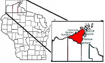
Bayfield Peninsula
Encyclopedia

Lake Superior
Lake Superior is the largest of the five traditionally-demarcated Great Lakes of North America. It is bounded to the north by the Canadian province of Ontario and the U.S. state of Minnesota, and to the south by the U.S. states of Wisconsin and Michigan. It is the largest freshwater lake in the...
. It is located in Bayfield County, Wisconsin USA. It is the northernmost region of mainland Wisconsin
Wisconsin
Wisconsin is a U.S. state located in the north-central United States and is part of the Midwest. It is bordered by Minnesota to the west, Iowa to the southwest, Illinois to the south, Lake Michigan to the east, Michigan to the northeast, and Lake Superior to the north. Wisconsin's capital is...
, with the south shore of Lake Superior to the west and the Chequamegon Bay
Chequamegon Bay
Chequamegon Bay is an inlet of Lake Superior, NE-SW and 2- wide, in Ashland and Bayfield counties in the extreme northern part of Wisconsin. It lies largely inside the barrier of Chequamegon Point and Long Island, with the Bad River Indian Reservation to the east. Ashland, Wisconsin is on its...
to the east. The peninsula is part of the Lake Superior Lowland
Lake Superior Lowland
In the U.S. state of Wisconsin, the Lake Superior Lowland, also known as the Superior Coastal Plain, is a geographical region located in the far northern part of the state bordering Lake Superior...
, though the interior southeast of Cornucopia
Cornucopia, Wisconsin
Cornucopia is an unincorporated census-designated place in the Town of Bell in northern Bayfield County, Wisconsin, United States. It is situated on Lake Superior at the northern end of the Bayfield Peninsula, on Wisconsin Highway 13. As of the 2010 census, its population was 98. The community...
and west of Bayfield
Bayfield, Wisconsin
Bayfield is a city in Bayfield County, Wisconsin, United States. The population was 611 at the 2000 census. The town is named after Henry Bayfield, a British Royal Topographic Engineer who explored the region in 1822-23....
has some higher ground including Pratt's Peak, Bayfield County's second-highest point. Highway 13
Highway 13 (Wisconsin)
State Trunk Highway 13 is a Wisconsin state highway running north–south across northwest and central Wisconsin. WIS 13 serves as a major north–south route connecting the communities of Wisconsin Dells, Wisconsin Rapids, Marshfield and Ashland...
runs around the peninsula along the Superior shoreline. The communities of Port Wing, Herbster, Cornucopia, Red Cliff
Red Cliff, Wisconsin
Red Cliff, also known as Miskwabiikong, is an unincorporated community in the town of Russell, Bayfield County, Wisconsin, United States. Red Cliff is the administrative center of the Red Cliff Band of Lake Superior Chippewa...
, Bayfield, Washburn
Washburn, Wisconsin
Washburn is a city in Bayfield County, in the U.S. state of Wisconsin. The population was 2,280 at the 2000 census. The city is just east of and adjacent to the Town of Washburn...
, and Ashland
Ashland, Wisconsin
Ashland is a city in Ashland and Bayfield counties in the U.S. state of Wisconsin. The city is a port on Lake Superior, near the head of Chequamegon Bay. The population was 8,695 at the 2010 census....
lie on this stretch of highway. The interior of the peninsula is mostly the northern end of the Chequamegon National Forest, an area of jackpine growth known as the Moquah Barrens. The Apostle Islands
Apostle Islands
The Apostle Islands are a group of 22 islands in Lake Superior, off the Bayfield Peninsula in northern Wisconsin. The majority of the islands are located in Ashland County—only Sand, York, Eagle, and Raspberry Islands are located in Bayfield County...
surround the end of the peninsula.

