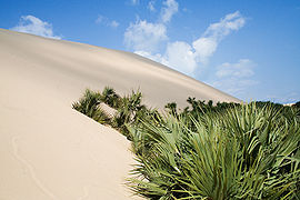
Bazaruto Island
Encyclopedia

Sand
Sand is a naturally occurring granular material composed of finely divided rock and mineral particles.The composition of sand is highly variable, depending on the local rock sources and conditions, but the most common constituent of sand in inland continental settings and non-tropical coastal...
y island
Island
An island or isle is any piece of sub-continental land that is surrounded by water. Very small islands such as emergent land features on atolls can be called islets, cays or keys. An island in a river or lake may be called an eyot , or holm...
located approximately 80 kilometres (49.7 mi) southeast of the mouth of the Save River, Mozambique
Mozambique
Mozambique, officially the Republic of Mozambique , is a country in southeastern Africa bordered by the Indian Ocean to the east, Tanzania to the north, Malawi and Zambia to the northwest, Zimbabwe to the west and Swaziland and South Africa to the southwest...
(21°38′S 35°30′E). It is the largest island in the Bazaruto Archipelago
Bazaruto Archipelago
The Bazaruto Archipelago is a group of six islands in Mozambique, near the mainland city of Vilankulo. It comprises the islands of Bazaruto, Benguerra, Magaruque, Banque, Santa Carolina and Shell....
and in the Bazaruto National Park
Bazaruto National Park
The Bazaruto National Park is a protected area in the Inhambane Province of Mozambique on the Bazaruto Archipelago.The park was proclaimed on 25 May 1971...
.
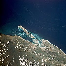
The warm, southward-flowing Mozambique Current
Mozambique Current
The Mozambique Current is an ocean current in the Indian Ocean, usually defined as warm surface waters flowing south along the African east coast in the Mozambique Channel, between Mozambique and the island of Madagascar....
seems to contribute to the increasing buildup of the sandy coastline. Because the water along this coastal area is very clear, much of the sub-surface channel pattern around the island is discernible. Several narrow lines of plankton
Plankton
Plankton are any drifting organisms that inhabit the pelagic zone of oceans, seas, or bodies of fresh water. That is, plankton are defined by their ecological niche rather than phylogenetic or taxonomic classification...
bloom parallel the shoreline on the satellite photo below.
The coastal plains show numerous lake
Lake
A lake is a body of relatively still fresh or salt water of considerable size, localized in a basin, that is surrounded by land. Lakes are inland and not part of the ocean and therefore are distinct from lagoons, and are larger and deeper than ponds. Lakes can be contrasted with rivers or streams,...
s and a swamp
Swamp
A swamp is a wetland with some flooding of large areas of land by shallow bodies of water. A swamp generally has a large number of hammocks, or dry-land protrusions, covered by aquatic vegetation, or vegetation that tolerates periodical inundation. The two main types of swamp are "true" or swamp...
y environment that appears to be karst topography
Karst topography
Karst topography is a geologic formation shaped by the dissolution of a layer or layers of soluble bedrock, usually carbonate rock such as limestone or dolomite, but has also been documented for weathering resistant rocks like quartzite given the right conditions.Due to subterranean drainage, there...
. Underlying the area is limestone rock that has eroded into a pockmarked landscape, creating water-filled sinkholes. Rainfall in this humid tropical climate amounts to around 850 mm (33 inches) annually, largely concentrated in the months December to March.
The closest mainland town to the island of Bazaruto is Inhassoro
Inhassoro
Inhassoro is a small fishing port in Inhassoro District of Inhambane Province in Mozambique. The town has about 43,000 inhabitants and is located on the Indian Ocean coast along the EN1 highway....
, although administratively it belongs to the Vilankulo District and Inhambane Province
Inhambane Province
Inhambane is a province of Mozambique located on the coast in the southern part of the country. It has an area of 68,615 km² and a population of 1.412.349 . The provincial capital is also called Inhambane....
.


