Beacon Mountain
Encyclopedia
Beacon Mountain, sometimes Mount Beacon, is the highest peak of the Hudson Highlands
, located behind the City of Beacon
, New York
, in the Town of Fishkill
. Its two summits rise above the Hudson River
behind the city and can easily be seen from Newburgh
across the river and many other places in the region. The more accessible northern peak, at 1,531 feet (467 m) above sea level, has a complex of radio antennas on its summit; the 1,610-foot (491 m) southern summit has a fire lookout tower
.
Beacon Reservoir, the city's main water source
, is located between North Beacon and neighboring Scofield Ridge, the highest peak in Putnam County
. Since much of the land on the mountains and up to the county line is owned by the city to protect the watershed
, an extensive system of roads and trails makes it a popular hiking
area. Both summits afford extensive views of the mid-Hudson region
, and on clear days New York City
is visible from the fire tower.
 In the past, North Beacon was home to Dutchess http://www.slackpacker.com/dutchess.htmlski area, and the remains of three ski trails can still be seen from the north. Additionally there was once the Mount Beacon Incline Railway
, which stopped running in 1978 but has since been added to the National Register of Historic Places
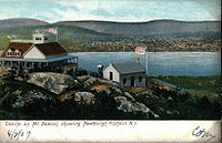
. Its track can still be seen going up the mountain and can be used to climb it, albeit steeply. At various other times in the past this summit housed a restaurant, a casino and a hotel.
 The mountains provided a key vantage point over West Point and Hudson River
, lending it historic roles in the American Revolution
. Signal fires
on the mountain gave both it and the nearby city their name. In 1901 the local chapter of the Daughters of the American Revolution
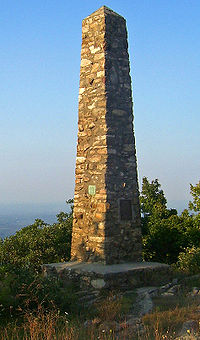
erected a monument at the site of the original signal fire near the summit of North Beacon.
The white-blazed Fishkill Ridge Trail leaves from the end of Pocket Road on the west side of Beacon. It can be followed for a mile up misnamed Dry Brook to the reservoir road. At the reservoir good roads continue up to the north summit, and at one corner the yellow-blazed Wilkinson Memorial Trail offers access to the south summit.
The Wilkinson Trail can also be followed from its southern terminus at NY 9D
south of the city, or its northern end near US 9 in Putnam County. Both routes require more time and distance, however.
One may also park and climb up the mountain from "Mount Beacon Park" in the City of Beacon. Parking area and trailhead are located at the intersection of Route 9D and Howland Avenue in the City of Beacon, across from Bob's Corner Store. The Park is part of the Scenic Hudson organization. http://www.scenichudson.org/whatyoucando/visitourparks/mountbeacon. Walk a quarter mile up the trail to see the remains of the old lower Railhead. Then a set of about 200 sturdy steps takes you a ways up the mountain to the first steep gravel and dirt trails. Even at this "lower" point you will have a great view of the river in the distance, especially when the leaves have fallen.
Hudson Highlands
The Hudson Highlands are mountains on both sides of the Hudson River in the U.S. state of New York, between Newburgh Bay and Haverstraw Bay, which form the northern region of the New York - New Jersey Highlands....
, located behind the City of Beacon
Beacon, New York
Beacon is a city located in Dutchess County, New York, United States. The 2010 census placed the city total population at 15,541. Beacon is part of the Poughkeepsie–Newburgh–Middletown, NY Metropolitan Statistical Area as well as the larger New York–Newark–Bridgeport,...
, New York
New York
New York is a state in the Northeastern region of the United States. It is the nation's third most populous state. New York is bordered by New Jersey and Pennsylvania to the south, and by Connecticut, Massachusetts and Vermont to the east...
, in the Town of Fishkill
Fishkill, New York
Fishkill is an upscale village within the much larger town, Town of Fishkill, one of the fastest growing towns in the region, in Dutchess County, New York, USA. The village population was 1,735 at the 2000 census...
. Its two summits rise above the Hudson River
Hudson River
The Hudson is a river that flows from north to south through eastern New York. The highest official source is at Lake Tear of the Clouds, on the slopes of Mount Marcy in the Adirondack Mountains. The river itself officially begins in Henderson Lake in Newcomb, New York...
behind the city and can easily be seen from Newburgh
Newburgh (city), New York
Newburgh is a city located in Orange County, New York, United States, north of New York City, and south of Albany, on the Hudson River. Newburgh is a principal city of the Poughkeepsie-Newburgh-Middletown metropolitan area, which includes all of Dutchess and Orange counties. The Newburgh area was...
across the river and many other places in the region. The more accessible northern peak, at 1,531 feet (467 m) above sea level, has a complex of radio antennas on its summit; the 1,610-foot (491 m) southern summit has a fire lookout tower
Fire lookout tower
A fire lookout tower, fire tower or lookout tower, provides housing and protection for a person known as a "fire lookout" whose duty it is to search for wildfires in the wilderness...
.
Beacon Reservoir, the city's main water source
Water supply
Water supply is the provision of water by public utilities, commercial organisations, community endeavours or by individuals, usually via a system of pumps and pipes...
, is located between North Beacon and neighboring Scofield Ridge, the highest peak in Putnam County
Putnam County, New York
Putnam County is a county located in the U.S. state of New York, in the lower Hudson River Valley. Putnam county formed in 1812, when it detached from Dutchess County. , the population was 99,710. It is part of the New York Metropolitan Area. The county seat is the hamlet of Carmel...
. Since much of the land on the mountains and up to the county line is owned by the city to protect the watershed
Drainage basin
A drainage basin is an extent or an area of land where surface water from rain and melting snow or ice converges to a single point, usually the exit of the basin, where the waters join another waterbody, such as a river, lake, reservoir, estuary, wetland, sea, or ocean...
, an extensive system of roads and trails makes it a popular hiking
Hiking
Hiking is an outdoor activity which consists of walking in natural environments, often in mountainous or other scenic terrain. People often hike on hiking trails. It is such a popular activity that there are numerous hiking organizations worldwide. The health benefits of different types of hiking...
area. Both summits afford extensive views of the mid-Hudson region
Hudson Valley
The Hudson Valley comprises the valley of the Hudson River and its adjacent communities in New York State, United States, from northern Westchester County northward to the cities of Albany and Troy.-History:...
, and on clear days New York City
New York City
New York is the most populous city in the United States and the center of the New York Metropolitan Area, one of the most populous metropolitan areas in the world. New York exerts a significant impact upon global commerce, finance, media, art, fashion, research, technology, education, and...
is visible from the fire tower.
History
Mount Beacon Incline Railway
The Mount Beacon Incline Railway was a popular tourist attraction in Beacon, New York, USA, and the neighboring Town of Fishkill. It operated for much of the 20th century, providing sweeping views of the Hudson Valley and efforts continue to restore it today....
, which stopped running in 1978 but has since been added to the National Register of Historic Places
National Register of Historic Places
The National Register of Historic Places is the United States government's official list of districts, sites, buildings, structures, and objects deemed worthy of preservation...
. Its track can still be seen going up the mountain and can be used to climb it, albeit steeply. At various other times in the past this summit housed a restaurant, a casino and a hotel.
Hudson River
The Hudson is a river that flows from north to south through eastern New York. The highest official source is at Lake Tear of the Clouds, on the slopes of Mount Marcy in the Adirondack Mountains. The river itself officially begins in Henderson Lake in Newcomb, New York...
, lending it historic roles in the American Revolution
American Revolution
The American Revolution was the political upheaval during the last half of the 18th century in which thirteen colonies in North America joined together to break free from the British Empire, combining to become the United States of America...
. Signal fires
Beacon
A beacon is an intentionally conspicuous device designed to attract attention to a specific location.Beacons can also be combined with semaphoric or other indicators to provide important information, such as the status of an airport, by the colour and rotational pattern of its airport beacon, or of...
on the mountain gave both it and the nearby city their name. In 1901 the local chapter of the Daughters of the American Revolution
Daughters of the American Revolution
The Daughters of the American Revolution is a lineage-based membership organization for women who are descended from a person involved in United States' independence....
erected a monument at the site of the original signal fire near the summit of North Beacon.
Approach
The easiest way up the mountain is a dirt road used by city employees doing maintenance work or inspections of the reservoir. It is, however, closed to public vehicular use.The white-blazed Fishkill Ridge Trail leaves from the end of Pocket Road on the west side of Beacon. It can be followed for a mile up misnamed Dry Brook to the reservoir road. At the reservoir good roads continue up to the north summit, and at one corner the yellow-blazed Wilkinson Memorial Trail offers access to the south summit.
The Wilkinson Trail can also be followed from its southern terminus at NY 9D
New York State Route 9D
New York State Route 9D , also known as the Bear Mountain – Beacon Highway, is a north–south state highway that runs along the eastern shore of the Hudson River in New York in the United States. It starts at the eastern end of the Bear Mountain Bridge at U.S...
south of the city, or its northern end near US 9 in Putnam County. Both routes require more time and distance, however.
One may also park and climb up the mountain from "Mount Beacon Park" in the City of Beacon. Parking area and trailhead are located at the intersection of Route 9D and Howland Avenue in the City of Beacon, across from Bob's Corner Store. The Park is part of the Scenic Hudson organization. http://www.scenichudson.org/whatyoucando/visitourparks/mountbeacon. Walk a quarter mile up the trail to see the remains of the old lower Railhead. Then a set of about 200 sturdy steps takes you a ways up the mountain to the first steep gravel and dirt trails. Even at this "lower" point you will have a great view of the river in the distance, especially when the leaves have fallen.

