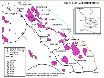
Big Island Lake Wilderness
Encyclopedia

Hiawatha National Forest
Hiawatha National Forest is a National Forest in the Upper Peninsula of the state of Michigan in the United States. Commercial logging is conducted in some areas. The United States Forest Service administers this National Forest; it is physically divided into two subunits, commonly called the...
in the Upper Peninsula in the state of Michigan
Michigan
Michigan is a U.S. state located in the Great Lakes Region of the United States of America. The name Michigan is the French form of the Ojibwa word mishigamaa, meaning "large water" or "large lake"....
in the United States. The wilderness area is located about one-half mile (0.8 km) northwest of the community of Steuben and 22 miles (35.4 km) northwest of Manistique
Manistique, Michigan
Manistique is a city in the Upper Peninsula of the U.S. state of Michigan. As of the 2000 census, the city population was 3,583. It is the county seat of Schoolcraft County and the only incorporated community in the county. The city lies on the north shore of Lake Michigan, at the southwest corner...
and about 18 miles (29 km) southeast of Munising
Munising, Michigan
Munising is a city on the southern shore of Lake Superior on the Upper Peninsula of the U.S. state of Michigan. As of the 2000 census, the city population was 2,539. It is the county seat of Alger County...
in Schoolcraft County
Schoolcraft County, Michigan
-National protected areas:* Hiawatha National Forest * Seney National Wildlife Refuge-Demographics:As of the census of 2000, there were 8,903 people, 3,606 households, and 2,498 families residing in the county. The population density was 8 people per square mile . There were 5,700 housing units...
. The area is roughly bordered by County Road 437 on the south and County Road 445 on the west. The northeast boundary is Forest Road 2303 and the southern boundary is the abandoned railroad grade—Haywire Grade - Forest Road 8109.

