
.gif)
Black River (Connecticut River)
Encyclopedia
United States
The United States of America is a federal constitutional republic comprising fifty states and a federal district...
state of Vermont
Vermont
Vermont is a state in the New England region of the northeastern United States of America. The state ranks 43rd in land area, , and 45th in total area. Its population according to the 2010 census, 630,337, is the second smallest in the country, larger only than Wyoming. It is the only New England...
, and a tributary
Tributary
A tributary or affluent is a stream or river that flows into a main stem river or a lake. A tributary does not flow directly into a sea or ocean...
of the Connecticut River
Connecticut River
The Connecticut River is the largest and longest river in New England, and also an American Heritage River. It flows roughly south, starting from the Fourth Connecticut Lake in New Hampshire. After flowing through the remaining Connecticut Lakes and Lake Francis, it defines the border between the...
. The watershed, or drainage basin, consists of some 202 square miles (523.2 km²) in southeastern Vermont, almost all of which lies in Windsor County.
Course
The Black River begins in a small body of water called Black Pond, in Plymouth, VermontPlymouth, Vermont
Plymouth is a town in Windsor County, Vermont, United States. The population was 555 at the 2000 census. Calvin Coolidge, the 30th President of the United States, was born in and is buried in Plymouth...
. Winding its way toward the town of Ludlow
Ludlow, Vermont
Ludlow, Vermont may refer to:*Ludlow , Vermont*Ludlow , Vermont...
, its narrow flow picks up a variety of small brooks and streams and is cooled by overhanging branches. Passing through Amherst Lake, Echo Lake, Lake Rescue
Lake Rescue (Vermont)
Lake Rescue is located in Windsor county of south central Vermont, in the northeastern United States. It is the tenth deepest and 23rd largest lake in Vermont. Lake Rescue is located along VT Route 100 about three miles north of Ludlow and Okemo Mountain, and it is surrounded by the town of Ludlow...
, and Lake Pauline, the Black River picks up more tributaries and winds through the town of Ludlow, the home of Okemo Mountain
Okemo Mountain
Okemo Mountain Resort is a ski resort located in Ludlow, Vermont. Before becoming a popular ski resort destination, Ludlow was originally a mill town, and was the home of a General Electric plant until 1977. The resort experienced 600,000 skier visits in 2009...
Ski Resort. Tumbling through impressive Cavendish Gorge, the river widens as it passes under the Downers Covered Bridge and enters Perkinsville
Perkinsville, Vermont
Perkinsville is a village located in the town of Weathersfield, Windsor County, Vermont. The population was 142 at the 2000 census.-Geography:...
.
The North Branch of the Black River, its headwaters in Reading
Reading, Vermont
Reading is a town in Windsor County, Vermont, United States. The population was 707 at the 2000 census.-History:On August 30, 1654, after being captured by Abenakis at Fort at Number 4, Charlestown, New Hampshire and being forced marched to Montreal, Susannah Willard Johnson gave birth to a...
, joins the main stem in Weathersfield
Weathersfield, Vermont
Weathersfield is a town in Windsor County, Vermont, United States. The population was 2,788 at the 2000 census.-Geography:According to the United States Census Bureau, the town has a total area of 44.2 square miles , of which 43.8 square miles is land and 0.4 square mile is...
at the flood control dam. Built by the Army Corps of Engineers between 1957–60, the dam holds back waters to protect the downstream towns of North Springfield
North Springfield, Vermont
North Springfield is an unincorporated community and census-designated place in Windsor County, Vermont, United States. It lies at an altitude of 495 feet . A post office has been operated in North Springfield since 1832....
and Springfield
Springfield, Vermont
Springfield is a town in Windsor County, Vermont, United States. The population was 9,373 at the 2010 census.-History:One of the New Hampshire grants, the township was chartered on August 20, 1761 by Governor Benning Wentworth and awarded to Gideon Lyman and 61 others...
from floods.
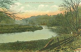
The Black River pushes on through these final two towns, past small dams and many industrial sites, until its final confluence with the Connecticut River at Hoyt's Landing, across from New Hampshire's Fort at Number 4
Fort at Number 4
The Fort at Number 4 was the northernmost British settlement along the Connecticut River in New Hampshire until after the French and Indian War. Now known as Charlestown, it was more than from the nearest other British settlement at Fort Dummer. Construction began in 1740 by brothers Stephen,...
in Charlestown
Charlestown, New Hampshire
Charlestown is a town in Sullivan County, New Hampshire, United States. The population was 5,114 at the 2010 census. The town is home to Hubbard State Forest and the headquarters of the Student Conservation Association....
.
History
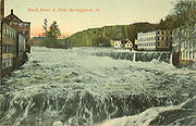
Flooding was a common occurrence on the Black River. Particularly noteworthy was the flood of 1927. A late-season tropical storm brought torrential rains to the lower towns of the watershed in early November. The small tributary streams overflowed their banks, releasing thousands of gallons of cold water into the Black River. Homes were lost, hundreds of thousands of dollars of damage was done, and businesses were destroyed.
1 Wood, John. A Leap in the Dark: How Springfield, Vermont Coped with Industrialization, Immigration and War, 1890-1920. Dissertation: California State University, 1987.
2 Lyndes, E.J. The Black River's Rampage, 1927: Springfield, VT. American Legion Press, 195_.
External references
- http://www.blackriveractionteam.org
- http://www.ctriver.org
- http://www.nae.usace.army.mil/recreati/nsl/nslhome.htm
- http://www.springfieldvt.com/toonerville.pdf
- http://www.swcrpc.org
- http://www.rootsweb.com/~vermont/WindsorSpringfield.html
- http://www.vacd.org
- http://www.trails.com/tcatalog_trail.asp?trailid=CGN027-015
- Lyndes, E.J. The Black River's Rampage, 1927: Springfield, VT. American Legion Press, 195_.
- Wood, John. A Leap in the Dark: How Springfield, Vermont Coped with Industrialization, Immigration and War, 1890-1920. Dissertation: California State University, 1987.