Blackheath, New South Wales
Encyclopedia
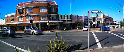
Blackheath is a small town located near the top of the Blue Mountains in New South Wales
, Australia
, 120 kilometres west north west of Sydney
and 11 kilometres northwest of Katoomba. In 2006, Blackheath had a population of 4,177 people. Many residents are weekly residents of Sydney or Lithgow
.

the region of Blackheath and surrounding areas were thought to be a summer corroberee meeting place for several Aboriginal nations, these being Darug
(East), Gundungurra (South) and Wiradjuri
(West). Due to the harsher climatic winter conditions, habitation would not have been feasible (see Geography & Climate). Some descendants of these people still reside in the modern township of 4104 persons and the surrounding areas (2001 ABS Census Data).
Blackheath was named in 1815 by Governor Lachlan Macquarie
after the colour of the native shrubbery in the area. Macquarie recorded in his journal: "This place having a black wild appearance I have this day named it Black-Heath." The name is also sometimes taken as reference to the occurrence of bleak weather and the locals have also coined the phrases, "Bleak-Heath" and "(b)Lack-Heat(h)". Whilst true to some extent, these names are somewhat of a misnomer as Blackheath enjoys a sunny, temperate climate. The area was originally named "Hounslow" by Governor Macquarie on his original trip through the area to Bathurst. He renamed it on his return journey.
The first building in Blackheath, the "Scotch Thistle Inn", was erected by Andrew Gardner in 1831. The inn was visited by Charles Darwin
in 1836. The extent of the original grant of land to Gardner can be seen today as the area bound by the Great Western Highway, Govetts Leap Road and (the misspelt) Gardiners Crescent.
Blackheath developed into a town after the railway line was built in 1869, the current station location being built in 1883. A large dam built to supply water for railway steam engines became the public baths when steam operations ceased upon electrification. Blackheath's original post office opened in 1910 and has now been converted into a gift shop and cafe.
Blackheath's sporting claim to fame is that Don Bradman hit a century off three overs for the Blackheath team in November 1931 at Blackheath Oval in a social match against Lithgow. He went on to make 256.
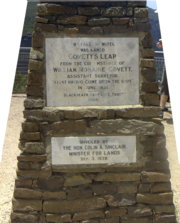
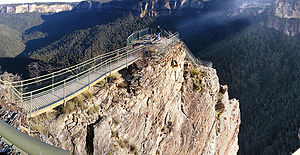
 A short drive from Blackheath takes visitors to Govetts Leap, a lookout with spectacular views of the Grose Valley and nearby waterfalls. According to folklore, a bushranger
named Govett rode off the cliff rather than be captured. This story is not verified by historical sources - the name draws on the definition of leap: "The sudden fall of a river to a lower level" (OED) and is named after William Romaine Govett, an assistant to the Surveyor General of NSW at the time, who first came upon that spot in June 1831. Evans Lookout provides an alternate vantage point for views into the same canyon system. Pulpit Rock, Perrys Lookdown and Anvil Rock are other lookouts close to the town, off Hat Hill Rd. There are several walking tracks starting from the lookouts, including short walks to enjoy different views, longer half and whole day walks, and walks involving camping overnight or several days walk. Canyoners and rockclimbers also base themselves at Blackheath for activities in the surrounding National Park.
 The area is known today for its colourful blooms in Spring and golden Autumn foliage as the weather begins to cool. In September, daffodils bloom and on the first weekend of November, Blackheath hosts an annual Rhododendron
Festival.
The Campbell Rhododendron Gardens http://www.rhodogarden.org.au at the northern end of the town in Bachante St have 45 acres (18.5 hectares) of Rhododendrons and Azaleas planted underneath a native Australian Bush canopy. They are tended by the volunteers of The Blue Mountains Rhododendron Society of NSW, many of whom live in the town. The Gardens are a spectacular sight in the spring months of September through to November.
The ornamental cherry trees that line the streets are out in full bloom in the first week of October - they are one of the spectacles of the Blue Mountains.
Mount Boyce
lookout is located just out of town towards Lithgow. The Megalong Valley
, about 18 km away, can be accessed from Blackheath.
Blackheath has many cafes and restaurants, a large antique centre and other shops of interest to tourists. It is a popular destination for people from Sydney for a weekend excursion or a Sunday drive.
from Hargraves Lookout in the west, past the tiny hamlet of Shipley. http://www.smh.com.au/news/New-South-Wales/Blackheath/2005/02/17/1108500192770.html
As the highest town in the Mountains, Blackheath receives snow in winter (two settled falls per season is the average with another five to ten days of light snow showers) and even in summer the temperatures are generally mild in comparison to other locations at the same latitude. Average maximum temperature in winter is around 8°C to 9°C although some days struggle to get above 5°C or 6°C. Frosts are common but topography tends to keep minimum temperatures in the -3°C to 2°C range. In summer, average maximum temperatures are around 23°C but it is quite common to see temperatures nudging 30°C on some days during mid-summer. Minimum temperatures in the summer are around 10°C-15°C.
Blackheath's location on a plateau makes it very vulnerable to high and sometimes destructive wind speeds, especially in the winter months when cold fronts surge up from the Southern Ocean. On July 5, 2011 a strong cold front passed over the area that produced winds that gusted up to 106km/h causing many trees to be uprooted and extensive damage to property.
Blackheath is also very fog and thunderstorm prone. Many days in summer are quite humid, allowing for moisture to build during the day, sometimes creating severe storms that can last for hours. http://www.blackheathweather.com/
Blackheath is surrounded by National Park which is prone to bushfires. In November 2006 severe bushfires threatened Blackheath from the north. http://www.nationalparks.nsw.gov.au/parks.nsf/ParkContent/N0004?OpenDocument&ParkKey=N0004&Type=FIRESUMMARY
Blackheath experiences a cool subtropical highland climate with monthly average temperatures not falling below -3°C and not exceeding 25°C. Blackheath's average annual precipitation is just over 1000 mm. http://www.bom.gov.au/jsp/ncc/cdio/weatherData/av?p_nccObsCode=139&p_display_type=dataFile&p_startYear=&p_stn_num=063295
New South Wales
New South Wales is a state of :Australia, located in the east of the country. It is bordered by Queensland, Victoria and South Australia to the north, south and west respectively. To the east, the state is bordered by the Tasman Sea, which forms part of the Pacific Ocean. New South Wales...
, Australia
Australia
Australia , officially the Commonwealth of Australia, is a country in the Southern Hemisphere comprising the mainland of the Australian continent, the island of Tasmania, and numerous smaller islands in the Indian and Pacific Oceans. It is the world's sixth-largest country by total area...
, 120 kilometres west north west of Sydney
Sydney
Sydney is the most populous city in Australia and the state capital of New South Wales. Sydney is located on Australia's south-east coast of the Tasman Sea. As of June 2010, the greater metropolitan area had an approximate population of 4.6 million people...
and 11 kilometres northwest of Katoomba. In 2006, Blackheath had a population of 4,177 people. Many residents are weekly residents of Sydney or Lithgow
Lithgow, New South Wales
Lithgow is a city in the Central Tablelands of New South Wales, Australia and is the centre of the local political division City of Lithgow. It is located in a mountain valley named Lithgow's Valley by John Oxley in honour of William Lithgow, the first Auditor-General of New South Wales.Lithgow is...
.

History
Prior to European settlement of AustraliaAustralia
Australia , officially the Commonwealth of Australia, is a country in the Southern Hemisphere comprising the mainland of the Australian continent, the island of Tasmania, and numerous smaller islands in the Indian and Pacific Oceans. It is the world's sixth-largest country by total area...
the region of Blackheath and surrounding areas were thought to be a summer corroberee meeting place for several Aboriginal nations, these being Darug
Darug people
The Darug people are a language group of Indigenous Australians, who are traditional custodians of much of what is modern day Sydney. There is some dispute about the extent of the Darug nation. Some historians believe the coastal Eora people were a separate tribe to the Darug...
(East), Gundungurra (South) and Wiradjuri
Wiradjuri
The Wiradjuri are an Indigenous Australian group of central New South Wales.In the 21st century, major Wiradjuri groups live in Condobolin, Peak Hill, Narrandera and Griffith...
(West). Due to the harsher climatic winter conditions, habitation would not have been feasible (see Geography & Climate). Some descendants of these people still reside in the modern township of 4104 persons and the surrounding areas (2001 ABS Census Data).
Blackheath was named in 1815 by Governor Lachlan Macquarie
Lachlan Macquarie
Major-General Lachlan Macquarie CB , was a British military officer and colonial administrator. He served as the last autocratic Governor of New South Wales, Australia from 1810 to 1821 and had a leading role in the social, economic and architectural development of the colony...
after the colour of the native shrubbery in the area. Macquarie recorded in his journal: "This place having a black wild appearance I have this day named it Black-Heath." The name is also sometimes taken as reference to the occurrence of bleak weather and the locals have also coined the phrases, "Bleak-Heath" and "(b)Lack-Heat(h)". Whilst true to some extent, these names are somewhat of a misnomer as Blackheath enjoys a sunny, temperate climate. The area was originally named "Hounslow" by Governor Macquarie on his original trip through the area to Bathurst. He renamed it on his return journey.
The first building in Blackheath, the "Scotch Thistle Inn", was erected by Andrew Gardner in 1831. The inn was visited by Charles Darwin
Charles Darwin
Charles Robert Darwin FRS was an English naturalist. He established that all species of life have descended over time from common ancestry, and proposed the scientific theory that this branching pattern of evolution resulted from a process that he called natural selection.He published his theory...
in 1836. The extent of the original grant of land to Gardner can be seen today as the area bound by the Great Western Highway, Govetts Leap Road and (the misspelt) Gardiners Crescent.
Blackheath developed into a town after the railway line was built in 1869, the current station location being built in 1883. A large dam built to supply water for railway steam engines became the public baths when steam operations ceased upon electrification. Blackheath's original post office opened in 1910 and has now been converted into a gift shop and cafe.
Blackheath's sporting claim to fame is that Don Bradman hit a century off three overs for the Blackheath team in November 1931 at Blackheath Oval in a social match against Lithgow. He went on to make 256.
Local attractions

Bushranger
Bushrangers, or bush rangers, originally referred to runaway convicts in the early years of the British settlement of Australia who had the survival skills necessary to use the Australian bush as a refuge to hide from the authorities...
named Govett rode off the cliff rather than be captured. This story is not verified by historical sources - the name draws on the definition of leap: "The sudden fall of a river to a lower level" (OED) and is named after William Romaine Govett, an assistant to the Surveyor General of NSW at the time, who first came upon that spot in June 1831. Evans Lookout provides an alternate vantage point for views into the same canyon system. Pulpit Rock, Perrys Lookdown and Anvil Rock are other lookouts close to the town, off Hat Hill Rd. There are several walking tracks starting from the lookouts, including short walks to enjoy different views, longer half and whole day walks, and walks involving camping overnight or several days walk. Canyoners and rockclimbers also base themselves at Blackheath for activities in the surrounding National Park.

Rhododendron
Rhododendron is a genus of over 1 000 species of woody plants in the heath family, most with showy flowers...
Festival.
The Campbell Rhododendron Gardens http://www.rhodogarden.org.au at the northern end of the town in Bachante St have 45 acres (18.5 hectares) of Rhododendrons and Azaleas planted underneath a native Australian Bush canopy. They are tended by the volunteers of The Blue Mountains Rhododendron Society of NSW, many of whom live in the town. The Gardens are a spectacular sight in the spring months of September through to November.
The ornamental cherry trees that line the streets are out in full bloom in the first week of October - they are one of the spectacles of the Blue Mountains.
Mount Boyce
Mount Boyce
Mount Boyce is a mountain, located 2 kilometres north of Blackheath, New South Wales is one of the highest points in the Blue Mountains, standing approximately 1093 metres above sea level, the point where the Great Western Highway passes by is the location of a heavy vehicle checking...
lookout is located just out of town towards Lithgow. The Megalong Valley
Megalong Valley
The Megalong Valley is part of the Blue Mountains of New South Wales, Australia. It is located west of Katoomba. On its eastern side, the valley is separated from the Jamison Valley by Narrow Neck Plateau. The Shipley Plateau overlooks part of the valley....
, about 18 km away, can be accessed from Blackheath.
Blackheath has many cafes and restaurants, a large antique centre and other shops of interest to tourists. It is a popular destination for people from Sydney for a weekend excursion or a Sunday drive.
Geography & Climate
The area around Blackheath contains some of the most spectacular views in the Blue Mountains, including those over the Grose Valley from Evans Lookout and Govetts Leap in the east, and the lesser-known vista of the Megalong ValleyMegalong Valley
The Megalong Valley is part of the Blue Mountains of New South Wales, Australia. It is located west of Katoomba. On its eastern side, the valley is separated from the Jamison Valley by Narrow Neck Plateau. The Shipley Plateau overlooks part of the valley....
from Hargraves Lookout in the west, past the tiny hamlet of Shipley. http://www.smh.com.au/news/New-South-Wales/Blackheath/2005/02/17/1108500192770.html
As the highest town in the Mountains, Blackheath receives snow in winter (two settled falls per season is the average with another five to ten days of light snow showers) and even in summer the temperatures are generally mild in comparison to other locations at the same latitude. Average maximum temperature in winter is around 8°C to 9°C although some days struggle to get above 5°C or 6°C. Frosts are common but topography tends to keep minimum temperatures in the -3°C to 2°C range. In summer, average maximum temperatures are around 23°C but it is quite common to see temperatures nudging 30°C on some days during mid-summer. Minimum temperatures in the summer are around 10°C-15°C.
Blackheath's location on a plateau makes it very vulnerable to high and sometimes destructive wind speeds, especially in the winter months when cold fronts surge up from the Southern Ocean. On July 5, 2011 a strong cold front passed over the area that produced winds that gusted up to 106km/h causing many trees to be uprooted and extensive damage to property.
Blackheath is also very fog and thunderstorm prone. Many days in summer are quite humid, allowing for moisture to build during the day, sometimes creating severe storms that can last for hours. http://www.blackheathweather.com/
Blackheath is surrounded by National Park which is prone to bushfires. In November 2006 severe bushfires threatened Blackheath from the north. http://www.nationalparks.nsw.gov.au/parks.nsf/ParkContent/N0004?OpenDocument&ParkKey=N0004&Type=FIRESUMMARY
Blackheath experiences a cool subtropical highland climate with monthly average temperatures not falling below -3°C and not exceeding 25°C. Blackheath's average annual precipitation is just over 1000 mm. http://www.bom.gov.au/jsp/ncc/cdio/weatherData/av?p_nccObsCode=139&p_display_type=dataFile&p_startYear=&p_stn_num=063295
See also
- List of Blue Mountains articles
- Blackheath : today from yesterday : the history of a town in the Blue Mountains of New South Wales, Peter C. Rickwood, Blackheath, N.S.W.: WriteLight for the Rotary Club of Blacheath, 2005. xii, 640 p. : ill., maps, ports. ; 26 cm. ISBN 0958193452 / 9780958193450
External links
- Blue Mountains city council
- Blue Mountains Tourism
- Blackheath Information Site
- Blue Mountains Online
- Blackheath Weather - Local site regarding snow and general weather in the area.
- Blackheath and District Horticultural Society
- Blackheath (Campbell) Rhododendron Gardens
- Blackheath Markets etc
- Blackheath Area Neighbourhood Centre
- (New) Ivanhoe Hotel, Blackheath
- Musical events in Ivanhoe Hotel
- Gardners Inn, Blackheath
- Blackheath Rhododendron Festival
- Blackheath Art Society
- Google Satellite Map of Blackheath
- Wikitravel page for Blackheath
- Accommodation

